ISS037-E-5089
| NASA Photo ID | ISS037-E-5089 |
| Focal Length | 650mm |
| Date taken | 2013.09.30 |
| Time taken | 22:18:45 GMT |
Resolutions offered for this image:
1000 x 593 pixels 540 x 320 pixels 1440 x 960 pixels 720 x 480 pixels 4256 x 2832 pixels 640 x 426 pixels
1000 x 593 pixels 540 x 320 pixels 1440 x 960 pixels 720 x 480 pixels 4256 x 2832 pixels 640 x 426 pixels


Spacecraft nadir point: 38.8° S, 179.0° E
Photo center point: 39.2° S, 175.6° E
Photo center point by machine learning:
Photo center point: 39.2° S, 175.6° E
Photo center point by machine learning:
Nadir to Photo Center: West
Spacecraft Altitude: 227 nautical miles (420km)
Country or Geographic Name: | NEW ZEALAND-NI |
Features: | MOUNT RUAPEHU, TONGARIRO VOLCANIC COMPLEX, SNOW, AGRICULTURAL FIELDS |
| Features Found Using Machine Learning: | |
Cloud Cover Percentage: | 10 (1-10)% |
Sun Elevation Angle: | 48° |
Sun Azimuth: | 37° |
Camera: | Nikon D3 Electronic Still Camera |
Focal Length: | 650mm |
Camera Tilt: | 42 degrees |
Format: | 4256E: 4256 x 2832 pixel CMOS sensor, 36.0mm x 23.9mm, total pixels: 12.87 million, Nikon FX format |
Film Exposure: | |
| Additional Information | |
| Width | Height | Annotated | Cropped | Purpose | Links |
|---|---|---|---|---|---|
| 1000 pixels | 593 pixels | No | Yes | Earth From Space collection | Download Image |
| 540 pixels | 320 pixels | Yes | Yes | Earth From Space collection | Download Image |
| 1440 pixels | 960 pixels | No | No | NASA's Earth Observatory web site | Download Image |
| 720 pixels | 480 pixels | Yes | No | NASA's Earth Observatory web site | Download Image |
| 4256 pixels | 2832 pixels | No | No | Download Image | |
| 640 pixels | 426 pixels | No | No | Download Image |
Download Packaged File
Download a Google Earth KML for this Image
View photo footprint information
Download a GeoTIFF for this photo
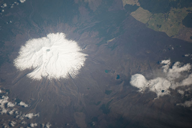
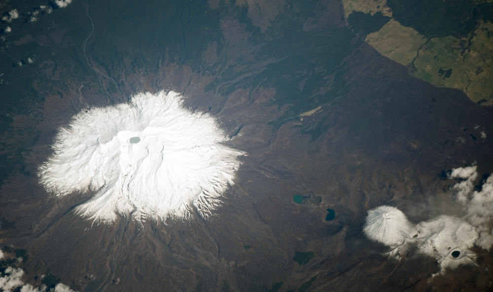
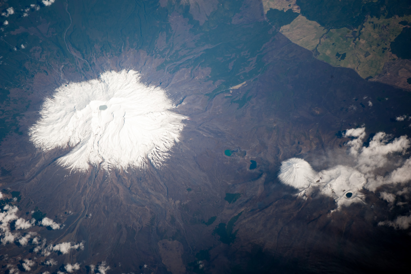
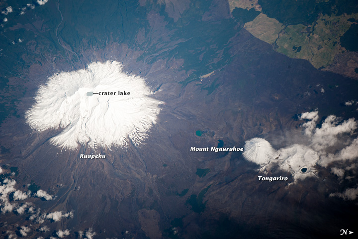
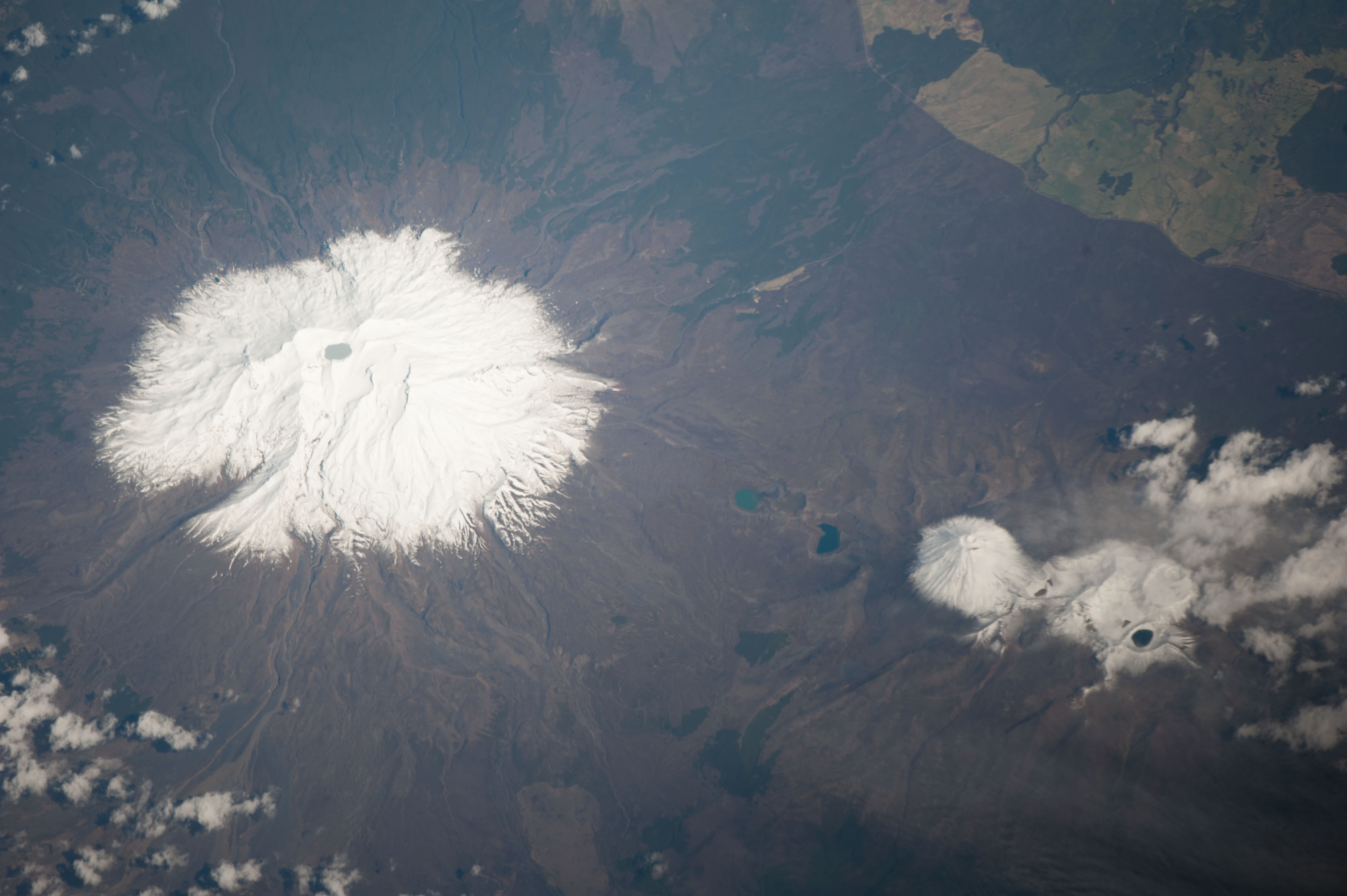
Image Caption: Ruapehu Volcano and Tongariro Volcanic Complex, New Zealand
Mount Ruapehu is one of several volcanic centers on the North Island of New Zealand, but is the largest and historically most active. The 2797 meter elevation volcano is also the highest mountain on North Island, and in this astronaut photograph from the International Space Station is covered with snow on its upper slopes. While there are three summit craters that have been active during the last 10,000 years, South Crater is the only historically active one.
This vent is currently filled with a lake (Crater Lake), visible at image left; eruptions from the vent, mixed with water from the lake can lead to the formation of lahars - destructive gravity flows of mixed fluid and volcanic debris that form a hazard to ski areas on the upper slopes and lower river valleys. The most recent significant eruption of Ruapehu took place in 2007 and formed both an eruption plume and lahars. The volcano is surrounded by a 100 cubic kilometer ring plain of volcaniclastic debris that appears dark grey in the image, whereas vegetated areas appear light to dark green.
Located to the northeast of the Ruapehu volcanic structure, the Tongariro volcanic complex (image lower right) is currently in an active eruptive phase - the previous eruptive phase ended in 1897. Explosive eruptions occurred in 2012, which have been followed by steam and gas plumes observed almost daily. The volcanic complex contains multiple cones constructed over the past 275,000 years. The most prominent of these, Mount Ngauruhoe, last erupted in 1975. Like Ruapehu, the upper slopes of both Ngauruhoe and the upper peaks of Tongariro are snow-covered. Scattered cloud cover is also visible near Tongariro at image lower right.
