ISS037-E-21618
| NASA Photo ID | ISS037-E-21618 |
| Focal Length | 1000mm |
| Date taken | 2013.10.26 |
| Time taken | 13:35:49 GMT |
Resolutions offered for this image:
1000 x 661 pixels 540 x 357 pixels 1440 x 960 pixels 720 x 480 pixels 6048 x 4032 pixels 640 x 427 pixels
1000 x 661 pixels 540 x 357 pixels 1440 x 960 pixels 720 x 480 pixels 6048 x 4032 pixels 640 x 427 pixels

Spacecraft nadir point: 48.1° N, 0.3° W
Photo center point: 49.5° N, 0.1° E
Photo center point by machine learning:
Photo center point: 49.5° N, 0.1° E
Photo center point by machine learning:
Nadir to Photo Center: North
Spacecraft Altitude: 222 nautical miles (411km)
Country or Geographic Name: | FRANCE |
Features: | LE HAVRE, PORT COMPLEX, SEINE RIVER, ENGLISH CHANNEL |
| Features Found Using Machine Learning: | |
Cloud Cover Percentage: | 10 (1-10)% |
Sun Elevation Angle: | 25° |
Sun Azimuth: | 210° |
Camera: | Nikon D3X Electronic Still Camera |
Focal Length: | 1000mm |
Camera Tilt: | 21 degrees |
Format: | 6048E: 6048 x 4032 pixel CMOS sensor, 35.9mm x 24.0mm, total pixels: 25.72 million, Nikon FX format |
Film Exposure: | |
| Additional Information | |
| Width | Height | Annotated | Cropped | Purpose | Links |
|---|---|---|---|---|---|
| 1000 pixels | 661 pixels | No | Yes | Earth From Space collection | Download Image |
| 540 pixels | 357 pixels | Yes | Yes | Earth From Space collection | Download Image |
| 1440 pixels | 960 pixels | No | No | NASA's Earth Observatory web site | Download Image |
| 720 pixels | 480 pixels | Yes | No | NASA's Earth Observatory web site | Download Image |
| 6048 pixels | 4032 pixels | No | No | Download Image | |
| 640 pixels | 427 pixels | No | No | Download Image |
Download Packaged File
Download a Google Earth KML for this Image
View photo footprint information
Download a GeoTIFF for this photo
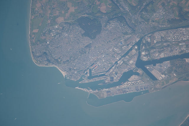
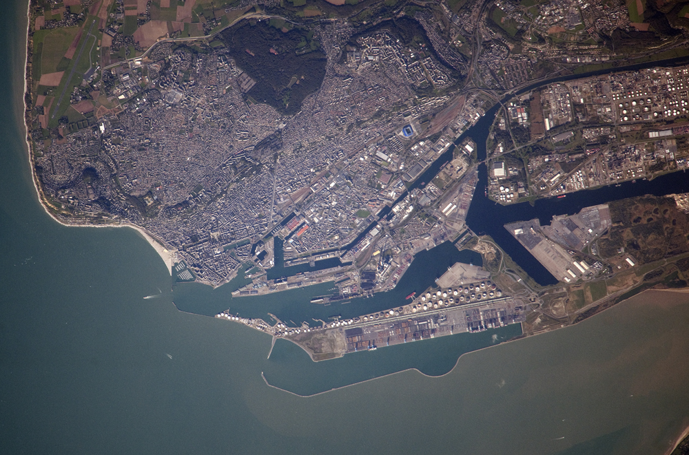
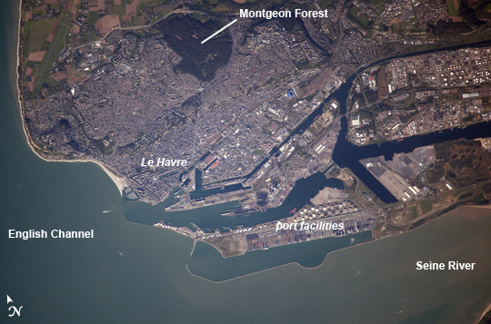
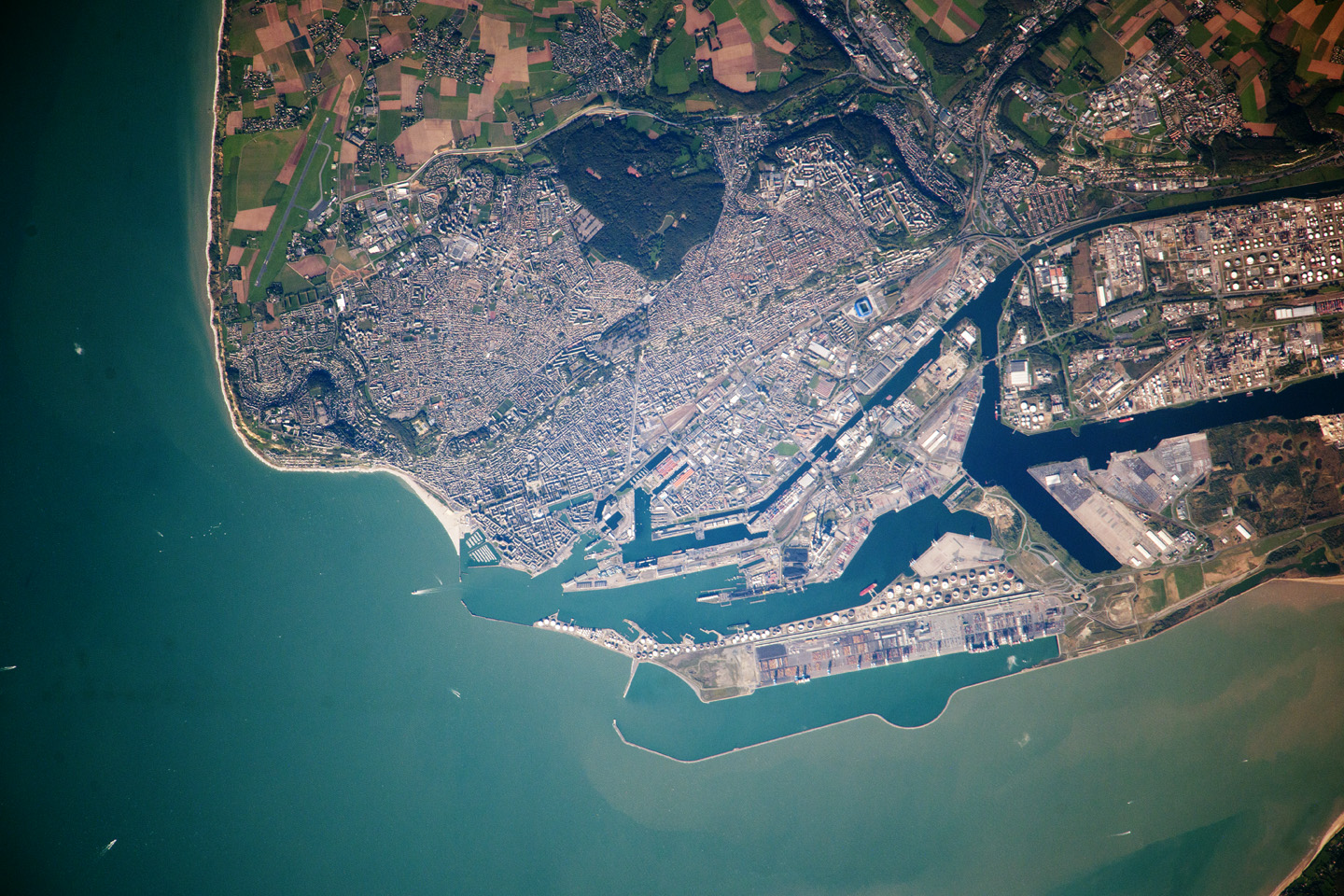
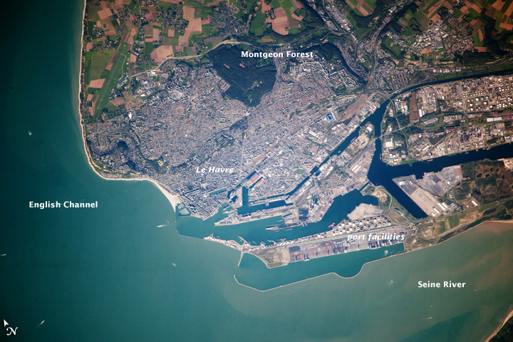
Image Caption: Le Havre, France
Note: This caption refers to the image versions labeled "NASA's Earth Observatory web site".
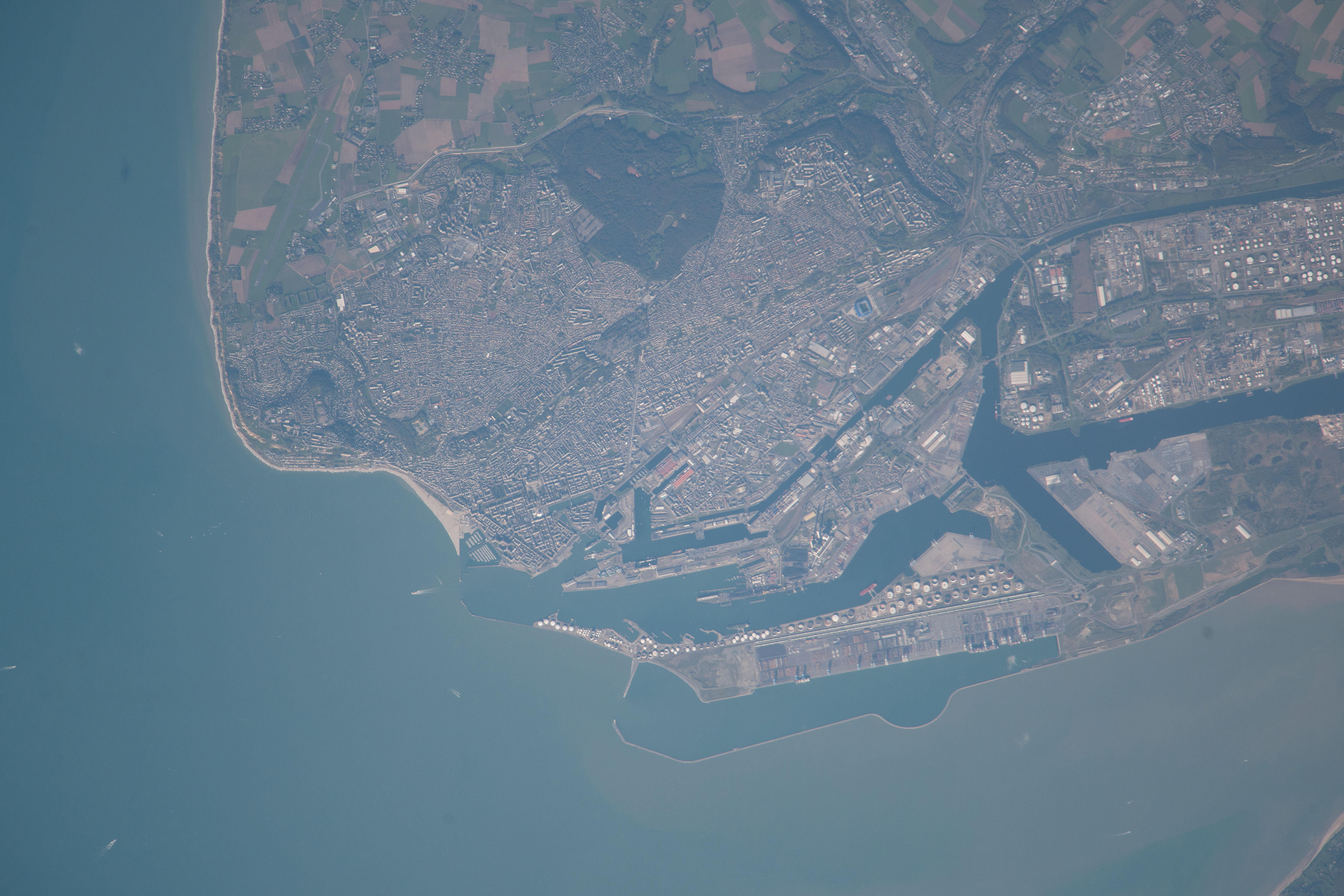
The port city of Le Havre, France is located at the confluence of the Seine River and the English Channel along the northern coastline of the country (Upper Normandy region). Le Havre is the largest container port in France, and the second largest in terms of total traffic after Marseille. The extensive port facilities, visible at image center, include numerous docks (large cargo ships are clearly visible in this detailed astronaut photograph), storage tanks for petro- and other chemicals, and large industrial and warehouse facilities with white rooftops. The port also serves seagoing pleasure cruise vessels. The southern edge of the port facility along the Seine includes a seawall-enclosed ship turning area (image lower center).
The Montgeon Forest, visible as a large green region at image upper center, includes 200 hectares of woodland and 30 hectares of meadows and lawns. The urban area of Le Havre, to the north of the port facilities, was largely destroyed during World War II. After the war, the city was rebuilt following the vision of architect Auguste Perret. Perret favored the use of reinforced and precast concrete in building structures, and much of the city built between 1945 and 1964 follows his plan in both form and materials - leading to the designation of Le Havre as a UNESCO World Heritage Site in 2005.
Note: This caption refers to the image versions labeled "NASA's Earth Observatory web site".
The port city of Le Havre, France is located at the confluence of the Seine River and the English Channel along the northern coastline of the country (Upper Normandy region). Le Havre is the largest container port in France, and the second largest in terms of total traffic after Marseille. The extensive port facilities, visible at image center, include numerous docks (large cargo ships are clearly visible in this detailed astronaut photograph), storage tanks for petro- and other chemicals, and large industrial and warehouse facilities with white rooftops. The port also serves seagoing pleasure cruise vessels. The southern edge of the port facility along the Seine includes a seawall-enclosed ship turning area (image lower center).
The Montgeon Forest, visible as a large green region at image upper center, includes 200 hectares of woodland and 30 hectares of meadows and lawns. The urban area of Le Havre, to the north of the port facilities, was largely destroyed during World War II. After the war, the city was rebuilt following the vision of architect Auguste Perret. Perret favored the use of reinforced and precast concrete in building structures, and much of the city built between 1945 and 1964 follows his plan in both form and materials - leading to the designation of Le Havre as a UNESCO World Heritage Site in 2005.
