ISS035-E-18807
| NASA Photo ID | ISS035-E-18807 |
| Focal Length | 400mm |
| Date taken | 2013.04.13 |
| Time taken | 11:29:27 GMT |
Resolutions offered for this image:
1000 x 665 pixels 540 x 359 pixels 1440 x 960 pixels 720 x 480 pixels 4256 x 2832 pixels 640 x 426 pixels
1000 x 665 pixels 540 x 359 pixels 1440 x 960 pixels 720 x 480 pixels 4256 x 2832 pixels 640 x 426 pixels


Cloud masks available for this image:
Spacecraft nadir point: 51.7° S, 30.2° W
Photo center point: 54.6° S, 36.2° W
Photo center point by machine learning:
Photo center point: 54.6° S, 36.2° W
Photo center point by machine learning:
Nadir to Photo Center: West
Spacecraft Altitude: 227 nautical miles (420km)
Camera: | Nikon D3S Electronic Still Camera |
Focal Length: | 400mm |
Camera Tilt: | High Oblique |
Format: | 4256E: 4256 x 2832 pixel CMOS sensor, 36.0mm x 23.9mm, total pixels: 12.87 million, Nikon FX format |
Film Exposure: | |
| Additional Information | |
| Width | Height | Annotated | Cropped | Purpose | Links |
|---|---|---|---|---|---|
| 1000 pixels | 665 pixels | No | Yes | Earth From Space collection | Download Image |
| 540 pixels | 359 pixels | Yes | Yes | Earth From Space collection | Download Image |
| 1440 pixels | 960 pixels | No | Yes | NASA's Earth Observatory web site | Download Image |
| 720 pixels | 480 pixels | Yes | No | NASA's Earth Observatory web site | Download Image |
| 4256 pixels | 2832 pixels | No | No | Download Image | |
| 640 pixels | 426 pixels | No | No | Download Image |
Download Packaged File
Download a Google Earth KML for this Image
View photo footprint information
Download a GeoTIFF for this photo
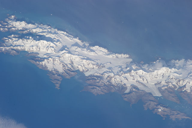
Image Caption: South Georgia and South Sandwich Islands, South Atlantic Ocean
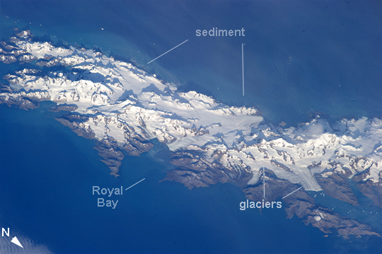
This astronaut photograph from the International Space Station (ISS) shows the eastern half of the island of South Georgia in the southern Atlantic Ocean. At 54 degrees S latitude, snow and ice are permanent everywhere except at altitudes near sea level, where temperatures are higher. Glaciers sourced in mountain snow and ice (eleven peaks raise higher than 2000 meters above sea level) can be seen reaching the sea (such as at image lower right). Calving icebergs are visible floating away from the ice front at image lower right. Other glaciers can be seen along the coastline at image center and image left. The island's glaciers are one of the major sources of erosion, producing fine sediment from grinding of rock and soil during ice movement over the land surface - this sediment is termed glacial flour, and it imparts a milky color to the surrounding water. The sediment is apparent as a lighter-toned zone offshore entirely surrounding the island.
South Georgia and the South Sandwich Islands, a British overseas territory, are a remote string of islands consisting of South Georgia and smaller islands known as the South Sandwich Islands. In 1882-1883, a German scientific expedition stationed at Royal Bay (center left) observed the transit of Venus and, amazingly, recorded waves produced by the eruption of Krakatoa, fully 12,330 km (7660 miles) distant. South Georgia is 170 kilometers long and is by far the largest island in the territory. The current population of South Georgia is less than 50. The main revenue of the island comes from fishing licenses which allow access to the rich fishing grounds--South Georgia has six separate whaling factories in various bays. Other revenue comes from tourism, customs and harbor dues, and the sale of postage stamps - most of which is spent on fishery protection and research.
While the ISS only orbits above locations between approximately 52 degrees North and South latitude, astronauts using handheld cameras can take images--such as this one--of regions at higher latitudes using long focal length lenses and high viewing angles. Such images tend to highlight topographic relief due to shadowing effects (image left), looking similar to the view one gets out of a commercial airliner window.
