ISS034-E-5496

| NASA Photo ID | ISS034-E-5496 |
| Focal Length | 180mm |
| Date taken | 2012.11.30 |
| Time taken | 22:27:38 GMT |
Resolutions offered for this image:
1000 x 664 pixels 540 x 359 pixels 4288 x 2848 pixels 720 x 480 pixels 4288 x 2848 pixels 640 x 425 pixels
1000 x 664 pixels 540 x 359 pixels 4288 x 2848 pixels 720 x 480 pixels 4288 x 2848 pixels 640 x 425 pixels

Cloud masks available for this image:
Spacecraft nadir point: 4.3° S, 149.5° E
Photo center point: 5.1° S, 151.3° E
Photo center point by machine learning:
Photo center point: 5.1° S, 151.3° E
Photo center point by machine learning:
Nadir to Photo Center: East
Spacecraft Altitude: 228 nautical miles (422km)
Country or Geographic Name: | PAPUA NEW GUINEA |
Features: | ULAWUN VOLCANO, ERUPTION PLUME, BAMUS VOLCANO, LOLOBAU ISLAND |
| Features Found Using Machine Learning: | |
Cloud Cover Percentage: | 10 (1-10)% |
Sun Elevation Angle: | 38° |
Sun Azimuth: | 114° |
Camera: | Nikon D2Xs Electronic Still Camera |
Focal Length: | 180mm |
Camera Tilt: | 27 degrees |
Format: | 4288E: 4288 x 2848 pixel CMOS sensor, RGBG imager color filter |
Film Exposure: | |
| Additional Information | |
| Width | Height | Annotated | Cropped | Purpose | Links |
|---|---|---|---|---|---|
| 1000 pixels | 664 pixels | No | Yes | Earth From Space collection | Download Image |
| 540 pixels | 359 pixels | Yes | Yes | Earth From Space collection | Download Image |
| 4288 pixels | 2848 pixels | No | Yes | NASA's Earth Observatory web site | Download Image |
| 720 pixels | 480 pixels | Yes | No | NASA's Earth Observatory web site | Download Image |
| 4288 pixels | 2848 pixels | No | No | Download Image | |
| 640 pixels | 425 pixels | No | No | Download Image |
Download Packaged File
Download a Google Earth KML for this Image
View photo footprint information
Download a GeoTIFF for this photo
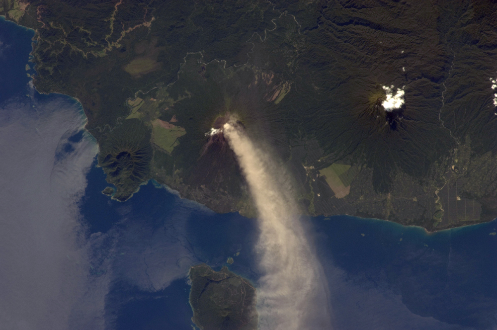
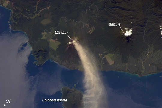
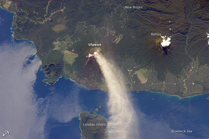
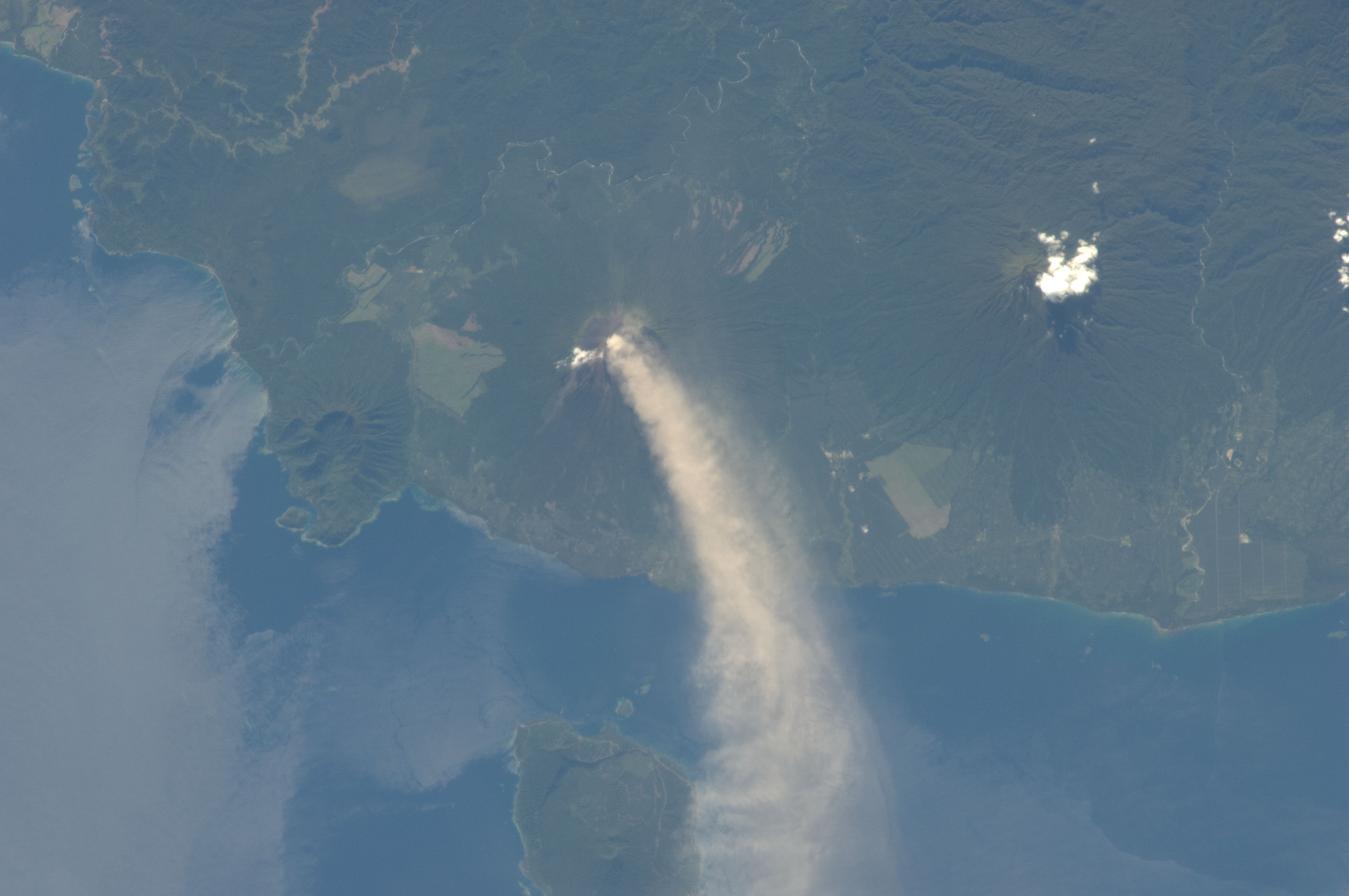
Image Caption: Eruption at Ulawun Volcano, New Britain Island, Papua New Guinea
Numerous volcanoes contribute to the landmass of the island of New Britain, the largest in the Bismarck Archipelago of Papua New Guinea. One of the most active of these volcanoes, Ulawun, is also the highest with a summit elevation of 2,334 meters. This astronaut photograph was taken during the most recent phase of volcanic activity at Ulawun. A white steam and ash plume extends from the summit crater of the stratovolcano towards the northwest (image center; note the image is oriented such that north is towards the lower left). The plume begins to broaden as it passes the southwestern coast of Lolobau Island approximately 23 kilometers downwind from its source.
Ulawun volcano is also known as "the Father", with the Bamus volcano to the southwest also known as "the South Son". The summit of Bamus is obscured by white cumulus clouds (not of volcanic origin) in this image. While Ulawun has been active since at least 1700, the most recent eruptive activity at Bamus occurred in the late 19th century. A large region of ocean surface highlighted by sunglint - sunlight reflecting off the water surface, lending it a mirror-like appearance- is visible to the north-northeast of Ulawun (image lower left).
