ISS034-E-35548
| NASA Photo ID | ISS034-E-35548 |
| Focal Length | 180mm |
| Date taken | 2013.01.28 |
| Time taken | 07:35:31 GMT |
Resolutions offered for this image:
1000 x 654 pixels 540 x 353 pixels 1440 x 960 pixels 720 x 480 pixels 4256 x 2832 pixels 640 x 426 pixels
1000 x 654 pixels 540 x 353 pixels 1440 x 960 pixels 720 x 480 pixels 4256 x 2832 pixels 640 x 426 pixels

Cloud masks available for this image:
Spacecraft nadir point: 40.2° N, 116.8° W
Photo center point: 39.5° N, 119.7° W
Photo center point by machine learning: 39.55° N, 119.71° W
Photo center point: 39.5° N, 119.7° W
Photo center point by machine learning: 39.55° N, 119.71° W
Nadir to Photo Center: West
Spacecraft Altitude: 223 nautical miles (413km)

Country or Geographic Name: | USA-NEVADA |
Features: | RENO AT NIGHT, PYRAMID LAKE, FERNLEY AT NIGHT |
| Features Found Using Machine Learning: | |
Cloud Cover Percentage: | 10 (1-10)% |
Sun Elevation Angle: | -67° |
Sun Azimuth: | 345° |
Camera: | Nikon D3S Electronic Still Camera |
Focal Length: | 180mm |
Camera Tilt: | 39 degrees |
Format: | 4256E: 4256 x 2832 pixel CMOS sensor, 36.0mm x 23.9mm, total pixels: 12.87 million, Nikon FX format |
Film Exposure: | |
| Additional Information | |
| Width | Height | Annotated | Cropped | Purpose | Links |
|---|---|---|---|---|---|
| 1000 pixels | 654 pixels | No | Yes | Earth From Space collection | Download Image |
| 540 pixels | 353 pixels | Yes | Yes | Earth From Space collection | Download Image |
| 1440 pixels | 960 pixels | No | Yes | NASA's Earth Observatory web site | Download Image |
| 720 pixels | 480 pixels | Yes | Yes | NASA's Earth Observatory web site | Download Image |
| 4256 pixels | 2832 pixels | No | No | Download Image | |
| 640 pixels | 426 pixels | No | No | Download Image |
Download Packaged File
Download a Google Earth KML for this Image
View photo footprint information
Download a GeoTIFF for this photo
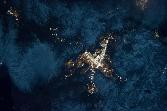
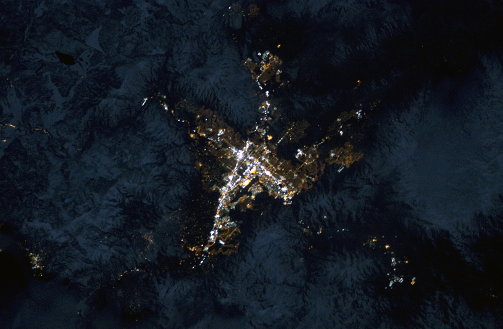
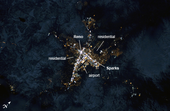
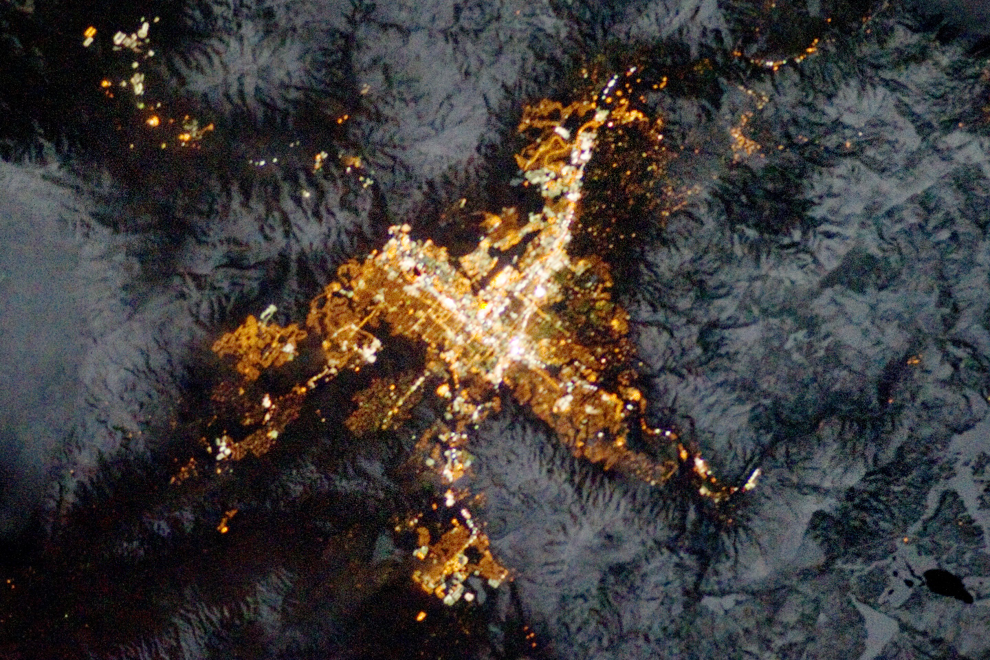
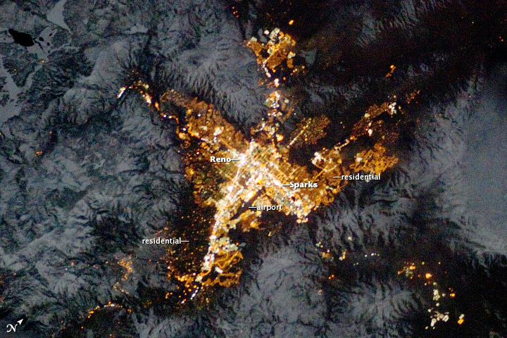
Image Caption: Reno, Nevada Metropolitan Area at Night
Note: This caption refers to the image versions labeled "NASA's Earth Observatory web site".
Known as "the biggest little city in the world", the city of Reno is located in Truckee Meadows along the eastern foothills of the Sierra Nevada near the California border. It forms part of the Reno-Sparks metropolitan area--the largest such area in northern Nevada, and the second largest in the state after Las Vegas. Lake Tahoe, a major destination for skiing and other outdoor recreational activities, is located less than 50 kilometers to the southwest of the Reno-Sparks metro area.
The relatively isolated nature of the metropolitan area within the surrounding terrain is highlighted in this night time image taken from the International Space Station. The major industrial and commercial areas of both Reno and Sparks are brightly lit at image center. The major street grid is visible as orange linear features adjacent to the industrial/commercial areas. Residential areas appear dark in contrast. The Reno-Tahoe International Airport (image center) is visible as a dark, dagger-shaped region in the southeast quarter of the metropolitan area.
At the time this astronaut photograph was taken, the Moon was in a waning gibbous phase (98% of a full moon). Moonlight provided enough illumination of the ground surface such that the topography, accentuated by snow cover, surrounding the Reno-Sparks area is clearly visible (image upper left, lower left) following color enhancement.
