ISS033-E-21663
| NASA Photo ID | ISS033-E-21663 |
| Focal Length | 400mm |
| Date taken | 2012.11.15 |
| Time taken | 10:53:36 GMT |
Resolutions offered for this image:
1000 x 665 pixels 540 x 359 pixels 1440 x 960 pixels 720 x 480 pixels 4256 x 2832 pixels 640 x 426 pixels
1000 x 665 pixels 540 x 359 pixels 1440 x 960 pixels 720 x 480 pixels 4256 x 2832 pixels 640 x 426 pixels
Cloud masks available for this image:
Spacecraft nadir point: 34.8° N, 95.1° W
Photo center point: 32.9° N, 96.8° W
Photo center point by machine learning: 32.92° N, 96.84° W
Photo center point: 32.9° N, 96.8° W
Photo center point by machine learning: 32.92° N, 96.84° W
Nadir to Photo Center: Southwest
Spacecraft Altitude: 223 nautical miles (413km)

Country or Geographic Name: | USA-TEXAS |
Features: | DALLAS AT NIGHT, CARROLLTON AT NIGHT, RICHARDSON AT NIGHT |
| Features Found Using Machine Learning: | |
Cloud Cover Percentage: | 0 (no clouds present) |
Sun Elevation Angle: | -25° |
Sun Azimuth: | 96° |
Camera: | Nikon D3S Electronic Still Camera |
Focal Length: | 400mm |
Camera Tilt: | 34 degrees |
Format: | 4256E: 4256 x 2832 pixel CMOS sensor, 36.0mm x 23.9mm, total pixels: 12.87 million, Nikon FX format |
Film Exposure: | |
| Additional Information | |
| Width | Height | Annotated | Cropped | Purpose | Links |
|---|---|---|---|---|---|
| 1000 pixels | 665 pixels | No | Yes | Earth From Space collection | Download Image |
| 540 pixels | 359 pixels | Yes | Yes | Earth From Space collection | Download Image |
| 1440 pixels | 960 pixels | No | Yes | NASA's Earth Observatory web site | Download Image |
| 720 pixels | 480 pixels | Yes | No | NASA's Earth Observatory web site | Download Image |
| 4256 pixels | 2832 pixels | No | No | Download Image | |
| 640 pixels | 426 pixels | No | No | Download Image |
Download Packaged File
Download a Google Earth KML for this Image
View photo footprint information
Download a GeoTIFF for this photo
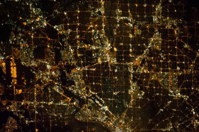
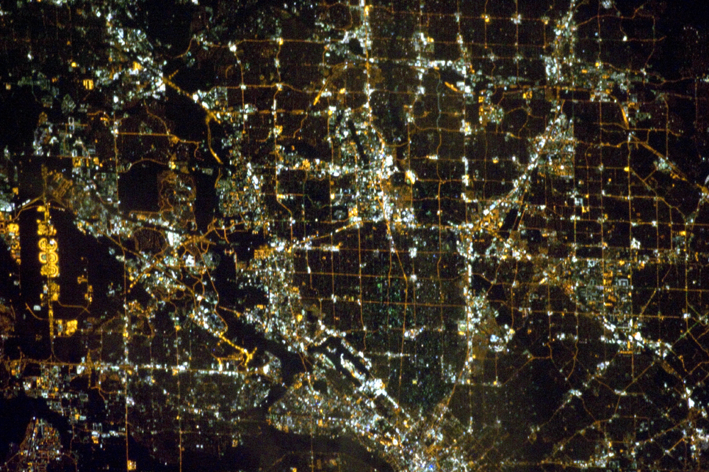
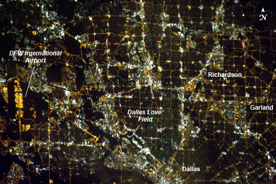
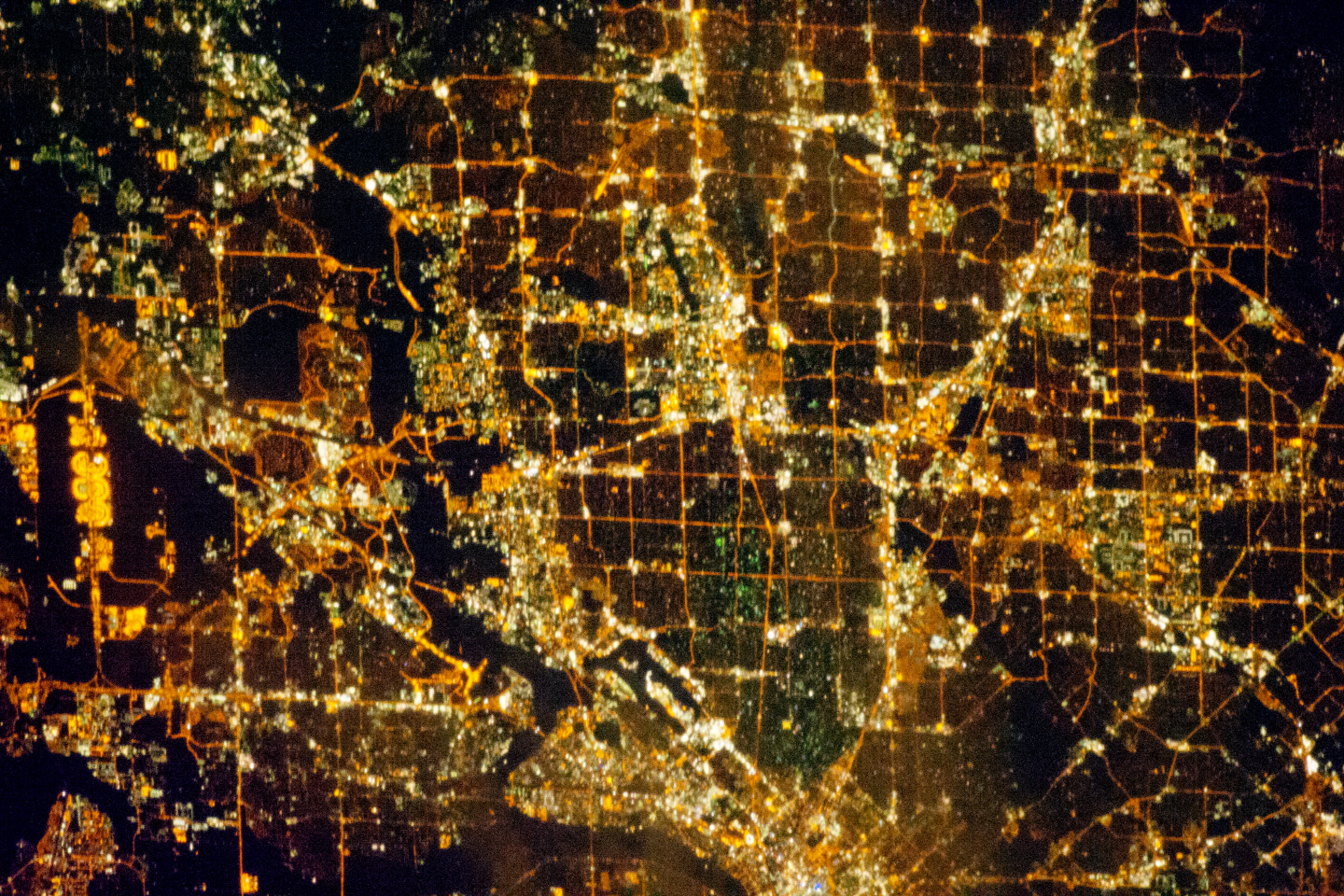
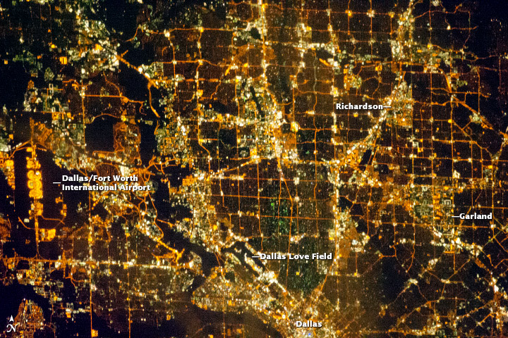
Image Caption: Dallas, Texas Metropolitan Area at Night
Most metropolitan areas of the western United States are configured over large areas with a regular street grid pattern that is highly recognizable from space, particularly at night. The northern Dallas, TX metropolitan area exhibits this pattern, visible in this astronaut photograph taken from the International Space Station. The north-south and east-west grid pattern of major surface streets is highlighted by orange street lighting, lending a fishnet-like appearance to the urban area. Within this framework, smaller residential and commercial buildings and streets give green-gray stipple patterns to some blocks.
The airplane terminals of Dallas-Fort Worth International Airport are lit with golden-yellow lights, and surrounded by relatively dark runways and fields at image left. Likewise, the runways of Dallas Love Field at image lower center are recognizable by their darkness. Other dark areas within the metro region are open space, parks, and water bodies. Larger commercial areas, public and industrial facilities appear as brilliantly like regions and points throughout the image.
Dallas is part of the larger Dallas-Fort Worth-Arlington Metropolitan Statistical Area (population 6,526,548 in 2011) as recognized by the U.S. Census Bureau; to most Texans, it is simply "DFW" or "the Metroplex". Several of the larger urban areas within DFW are visible in this image; Dallas, Garland and Richardson all have populations above 100,000 according to the North Central Texas Council of Governments. While historically the economy of Dallas was based in the oil and cotton industries, today commerce, technology, healthcare, and transportation are the major economic drivers.
