ISS033-E-20288
| NASA Photo ID | ISS033-E-20288 |
| Focal Length | 400mm |
| Date taken | 2012.11.13 |
| Time taken | 01:37:48 GMT |
Resolutions offered for this image:
1000 x 1503 pixels 540 x 812 pixels 1440 x 960 pixels 720 x 480 pixels 4256 x 2832 pixels 640 x 426 pixels
1000 x 1503 pixels 540 x 812 pixels 1440 x 960 pixels 720 x 480 pixels 4256 x 2832 pixels 640 x 426 pixels
Cloud masks available for this image:
Spacecraft nadir point: 24.9° N, 46.3° E
Photo center point: 24.8° N, 46.7° E
Photo center point by machine learning: 24.72° N, 46.71° E
Photo center point: 24.8° N, 46.7° E
Photo center point by machine learning: 24.72° N, 46.71° E
Nadir to Photo Center: East
Spacecraft Altitude: 224 nautical miles (415km)

Country or Geographic Name: | SAUDI ARABIA |
Features: | RIYADH AT NIGHT |
| Features Found Using Machine Learning: | |
Cloud Cover Percentage: | 10 (1-10)% |
Sun Elevation Angle: | -21° |
Sun Azimuth: | 101° |
Camera: | Nikon D3S Electronic Still Camera |
Focal Length: | 400mm |
Camera Tilt: | 06 degrees |
Format: | 4256E: 4256 x 2832 pixel CMOS sensor, 36.0mm x 23.9mm, total pixels: 12.87 million, Nikon FX format |
Film Exposure: | |
| Additional Information | |
| Width | Height | Annotated | Cropped | Purpose | Links |
|---|---|---|---|---|---|
| 1000 pixels | 1503 pixels | No | Yes | Earth From Space collection | Download Image |
| 540 pixels | 812 pixels | Yes | Yes | Earth From Space collection | Download Image |
| 1440 pixels | 960 pixels | No | Yes | NASA's Earth Observatory web site | Download Image |
| 720 pixels | 480 pixels | Yes | No | NASA's Earth Observatory web site | Download Image |
| 4256 pixels | 2832 pixels | No | No | Download Image | |
| 640 pixels | 426 pixels | No | No | Download Image |
Download Packaged File
Download a Google Earth KML for this Image
View photo footprint information
Download a GeoTIFF for this photo
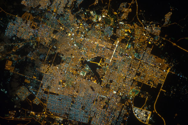
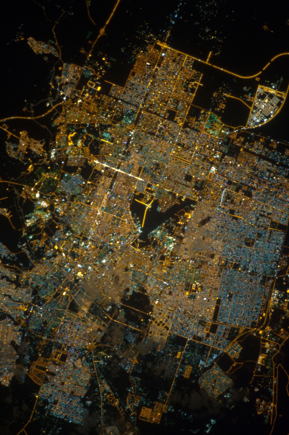
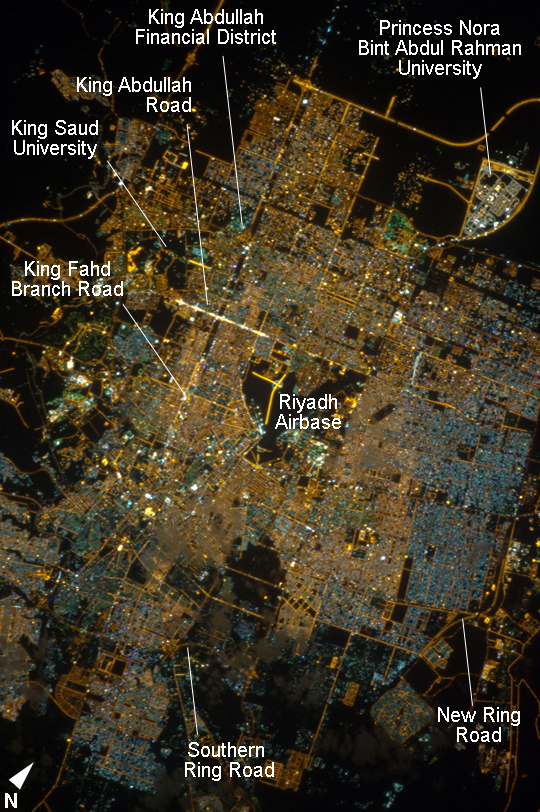
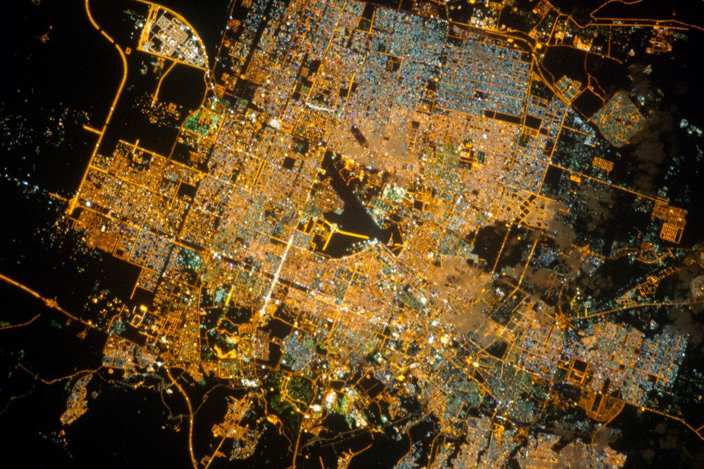
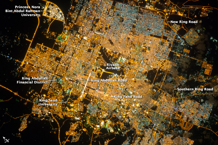
Image Caption: Riyadh, Saudi Arabia, at Night
Note: This caption refers to the image versions labeled "NASA's Earth Observatory web site".
The population of Riyadh, the capital city of Saudi Arabia, has risen dramatically in the last half century, from 150,000 in 1960 to an estimated 5.4 million in 2012. The city appears as a brightly colored patchwork in this night time astronaut photograph. The brightest lights, apart from those on the old Riyadh Airbase at image center (the new international airport is far outside the city and not shown here), follow the commercial districts along King Abdullah Road and King Fahd Branch Road. Many of the darker patches within the built area are city parks.
University sectors stand out with different street and light patterns, as seen in the King Saud University campus which houses the Arabic Language Institute, and the Princess Nora Bint Abdul Rahman University which is the largest all-female university in the world. Highways and various ring roads also stand out in night imagery due to bright regular lighting. Lighted developments beyond the ring roads mark the growth of the city (image lower left and lower right). Newer neighborhoods, set further from the city center, are recognizable by blue-gray lightning (ex. image right).
