ISS031-E-6398
| NASA Photo ID | ISS031-E-6398 |
| Focal Length | 400mm |
| Date taken | 2012.04.30 |
| Time taken | 19:26:19 GMT |
Resolutions offered for this image:
1000 x 652 pixels 540 x 352 pixels 720 x 480 pixels 4288 x 2848 pixels 640 x 425 pixels
1000 x 652 pixels 540 x 352 pixels 720 x 480 pixels 4288 x 2848 pixels 640 x 425 pixels

Cloud masks available for this image:
Spacecraft nadir point: 40.4° N, 109.4° W
Photo center point: 37.3° N, 110.8° W
Photo center point by machine learning:
Photo center point: 37.3° N, 110.8° W
Photo center point by machine learning:
Nadir to Photo Center: South
Spacecraft Altitude: 212 nautical miles (393km)
Country or Geographic Name: | USA-UTAH |
Features: | LAKE POWELL, THE RINCON, GLEN CANYON, SUNGLINT |
| Features Found Using Machine Learning: | |
Cloud Cover Percentage: | 0 (no clouds present) |
Sun Elevation Angle: | 65° |
Sun Azimuth: | 187° |
Camera: | Nikon D2Xs Electronic Still Camera |
Focal Length: | 400mm |
Camera Tilt: | 44 degrees |
Format: | 4288E: 4288 x 2848 pixel CMOS sensor, RGBG imager color filter |
Film Exposure: | |
| Additional Information | |
| Width | Height | Annotated | Cropped | Purpose | Links |
|---|---|---|---|---|---|
| 1000 pixels | 652 pixels | No | Yes | Earth From Space collection | Download Image |
| 540 pixels | 352 pixels | Yes | Yes | Earth From Space collection | Download Image |
| 720 pixels | 480 pixels | Yes | Yes | NASA's Earth Observatory web site | Download Image |
| 4288 pixels | 2848 pixels | No | No | Download Image | |
| 640 pixels | 425 pixels | No | No | Download Image |
Download Packaged File
Download a Google Earth KML for this Image
View photo footprint information
Download a GeoTIFF for this photo
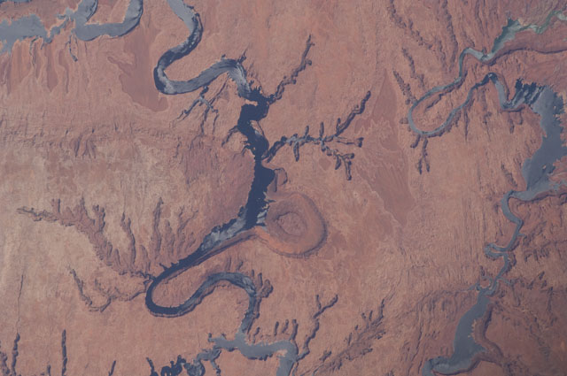
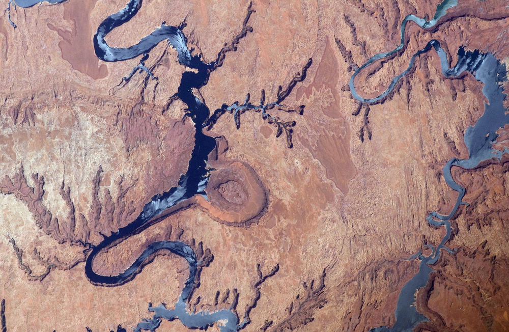
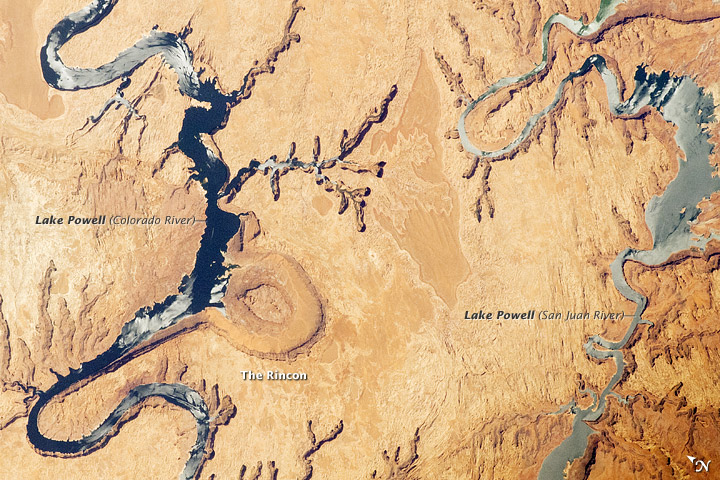
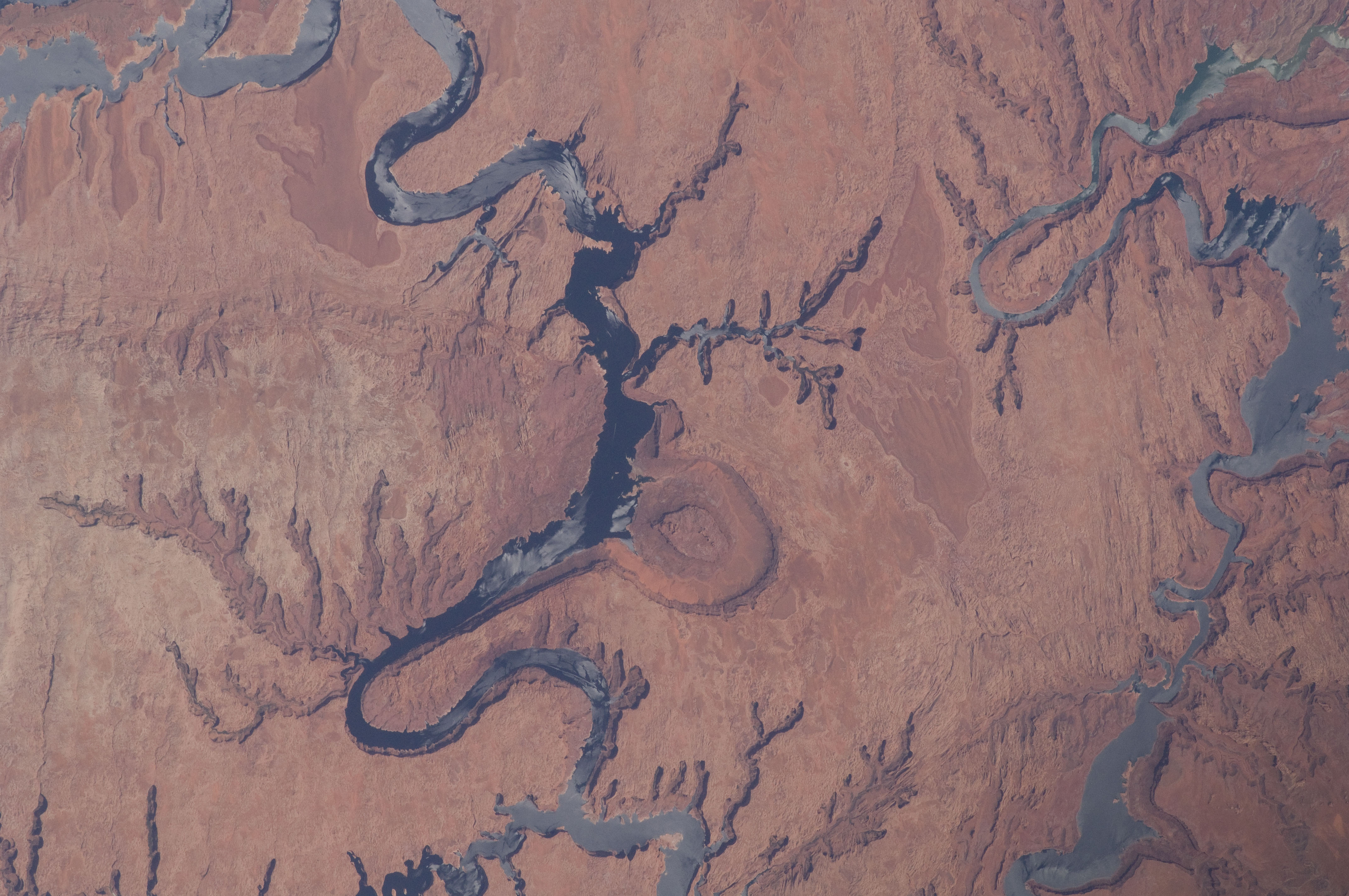
Image Caption: Lake Powell and The Rincon, Utah
This astronaut photograph highlights part of Lake Powell; the lake extends across southeastern Utah and northeastern Arizona. Lake Powell started filling in 1963 when the Glen Canyon Dam on the Colorado River in Arizona was completed, and Glen Canyon flooded. The serpentine water surface of the reservoir-highlighted by gray regions of sunglint-follows the incised course of the canyon. Today Lake Powell is part of the Glen Canyon National Recreation Area which extends for more than 186 miles along the shoreline and side canyons. The primary intended use of Lake Powell's water is support of agricultural production, with a small portion allocated to urban use in Arizona, Nevada, and California.
The reservoir did not reach its maximum capacity of 27 million acre-feet until 1980. More recently, extended drought conditions in the southwestern United States over the past decade have resulted in a significant lowering of the Lake water level and emergence of parts of Glen Canyon. Should average precipitation in the Colorado River watershed lessen (as predicted by regional climate change models), that could result in further lowering of the Lake Powell water level and changes to the current water management plans.
Fluctuations in water levels and change of river courses are a common occurrence seen in the geologic record of rivers. Looking somewhat like a donut or automobile tire from the vantage point of the International Space Station, The Rincon (image center) is an entrenched and abandoned meander, or loop, of the Colorado River, though to have formed several thousand years ago when the river cut straight across the ends of the loop and shortened its course by six miles. The resulting canyon and 600 - 750 feet-high central mesa indicate where the river used to flow. The term "rincon" also is used by geomorphologists to describe similar ancient river features observed elsewhere. The Goosenecks of the San Juan River are an example of an active entrenched meander.
