ISS030-E-90012
| NASA Photo ID | ISS030-E-90012 |
| Focal Length | 400mm |
| Date taken | 2012.02.05 |
| Time taken | 12:15:57 GMT |
Resolutions offered for this image:
1000 x 664 pixels 540 x 359 pixels 720 x 480 pixels 4288 x 2848 pixels 640 x 425 pixels
1000 x 664 pixels 540 x 359 pixels 720 x 480 pixels 4288 x 2848 pixels 640 x 425 pixels
Cloud masks available for this image:
Spacecraft nadir point: 23.6° S, 51.4° W
Photo center point: 21.2° S, 51.9° W
Photo center point by machine learning:
Photo center point: 21.2° S, 51.9° W
Photo center point by machine learning:
Nadir to Photo Center: North
Spacecraft Altitude: 220 nautical miles (407km)
Country or Geographic Name: | BRAZIL |
Features: | PARANA R. FLOODPLAIN, VERDE R., AGR. |
| Features Found Using Machine Learning: | |
Cloud Cover Percentage: | 10 (1-10)% |
Sun Elevation Angle: | 42° |
Sun Azimuth: | 91° |
Camera: | Nikon D2Xs Electronic Still Camera |
Focal Length: | 400mm |
Camera Tilt: | 34 degrees |
Format: | 4288E: 4288 x 2848 pixel CMOS sensor, RGBG imager color filter |
Film Exposure: | |
| Additional Information | |
| Width | Height | Annotated | Cropped | Purpose | Links |
|---|---|---|---|---|---|
| 1000 pixels | 664 pixels | No | Yes | Earth From Space collection | Download Image |
| 540 pixels | 359 pixels | Yes | Yes | Earth From Space collection | Download Image |
| 720 pixels | 480 pixels | Yes | Yes | NASA's Earth Observatory web site | Download Image |
| 4288 pixels | 2848 pixels | No | No | Download Image | |
| 640 pixels | 425 pixels | No | No | Download Image |
Download Packaged File
Download a Google Earth KML for this Image
View photo footprint information
Download a GeoTIFF for this photo
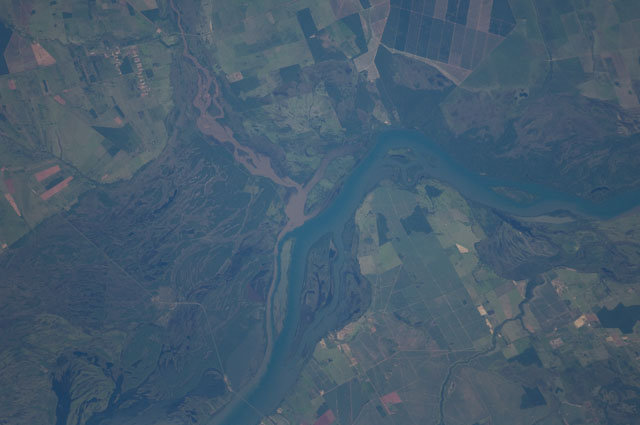
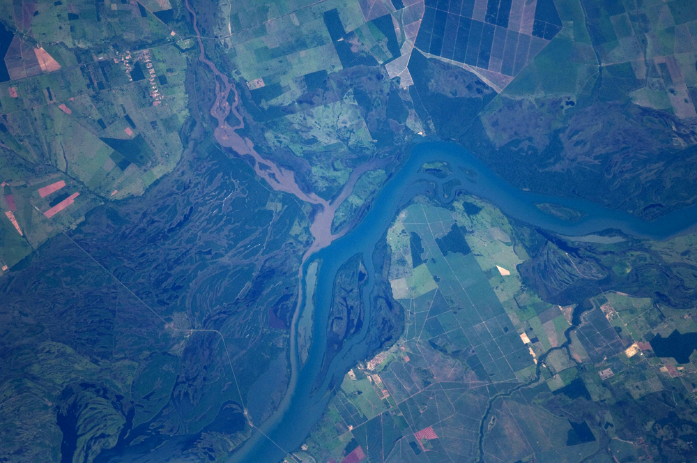
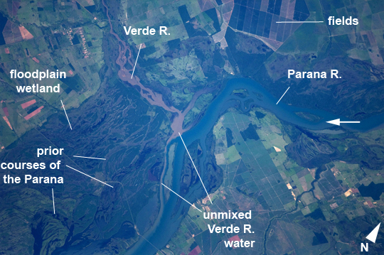
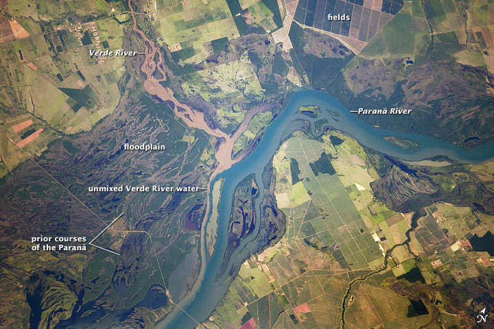
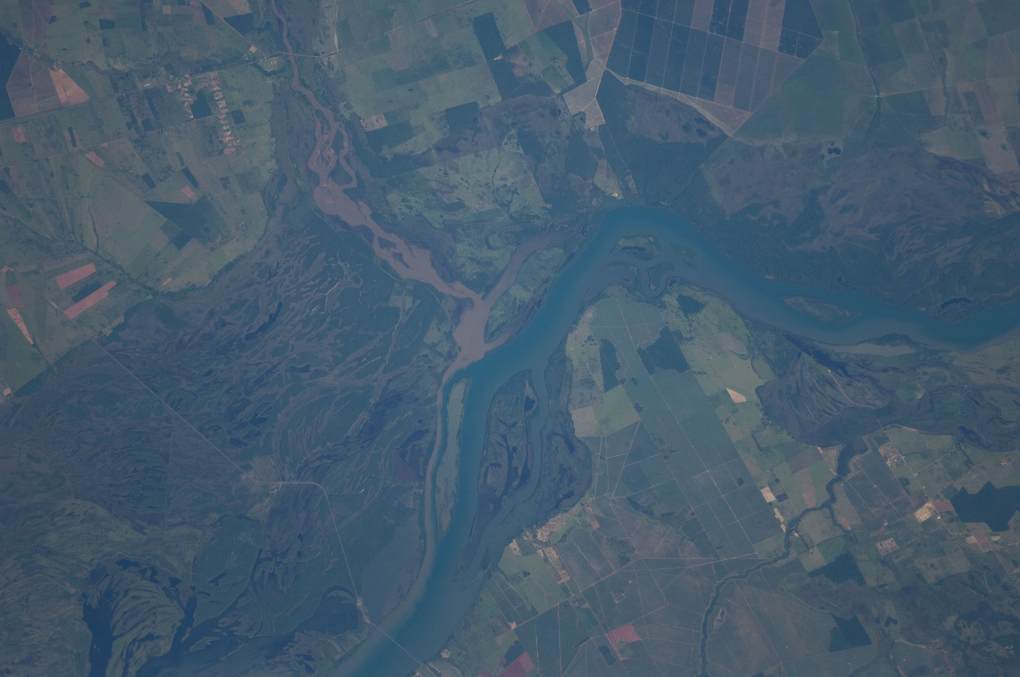
Image Caption: Parana River Floodplain, Mato Grosso-Sao Paulo border, Brazil
The Parana River appears as a wide, blue strip across this astronaut photograph, with muddy brown water of the smaller Verde River entering from the northwest (top left). An extensive wetland (dark green) occupies most of the left half of the image, where the floodplain of the river reaches a width of 11 kilometers. The thin line of a road crossing the floodplain also gives a sense of scale. Above the Parana-Verde confluence (image center) the floodplain is much narrower.
The floodplain is generated by sediments delivered by both rivers. Evidence for this is that the entire surface of the floodplain is crisscrossed by the wider traces of former Parana R. channels as well as numerous narrower traces of the Verde R. The floodplains along both rivers are bordered by numerous rectangular agricultural fields. Dominant crops along this part of the Parana River are coffee, corn and cotton.
Turbid water, such as that in the Verde River, is common in most rivers that drain plowed agricultural land as some topsoil is washed into local rivers after rains. A long tendril of brown water extends from the Verde R. into the main channel of the Parana River where it hugs the west bank, remaining unmixed for many kilometers. This effectively shows the direction of river flow from orbit (right to left for the Parana, upper left to image center for the Verde).
