ISS030-E-35487
| NASA Photo ID | ISS030-E-35487 |
| Focal Length | 180mm |
| Date taken | 2012.01.14 |
| Time taken | 13:56:26 GMT |
Resolutions offered for this image:
1000 x 664 pixels 540 x 359 pixels 720 x 480 pixels 4288 x 2848 pixels 640 x 425 pixels
1000 x 664 pixels 540 x 359 pixels 720 x 480 pixels 4288 x 2848 pixels 640 x 425 pixels


Cloud masks available for this image:
Spacecraft nadir point: 3.6° S, 37.9° E
Photo center point: 1.9° S, 36.3° E
Photo center point by machine learning:
Photo center point: 1.9° S, 36.3° E
Photo center point by machine learning:
Nadir to Photo Center: Northwest
Spacecraft Altitude: 212 nautical miles (393km)
Country or Geographic Name: | KENYA |
Features: | LAKE MAGADI, SOUTHERN LAKE NATRON |
| Features Found Using Machine Learning: | |
Cloud Cover Percentage: | 10 (1-10)% |
Sun Elevation Angle: | 25° |
Sun Azimuth: | 248° |
Camera: | Nikon D2Xs Electronic Still Camera |
Focal Length: | 180mm |
Camera Tilt: | 33 degrees |
Format: | 4288E: 4288 x 2848 pixel CMOS sensor, RGBG imager color filter |
Film Exposure: | |
| Additional Information | |
| Width | Height | Annotated | Cropped | Purpose | Links |
|---|---|---|---|---|---|
| 1000 pixels | 664 pixels | No | Yes | Earth From Space collection | Download Image |
| 540 pixels | 359 pixels | Yes | Yes | Earth From Space collection | Download Image |
| 720 pixels | 480 pixels | Yes | No | NASA's Earth Observatory web site | Download Image |
| 4288 pixels | 2848 pixels | No | No | Download Image | |
| 640 pixels | 425 pixels | No | No | Download Image |
Download Packaged File
Download a Google Earth KML for this Image
View photo footprint information
Download a GeoTIFF for this photo
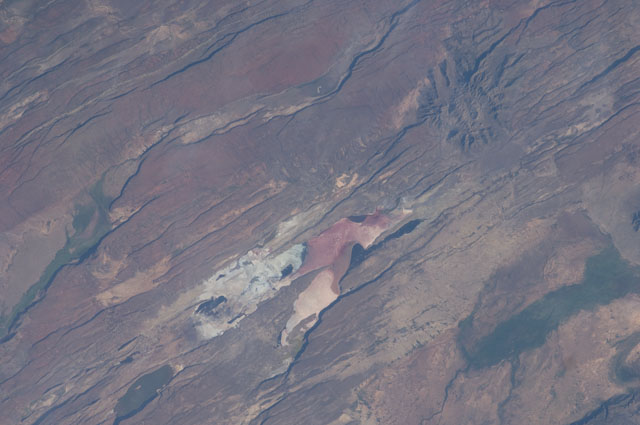
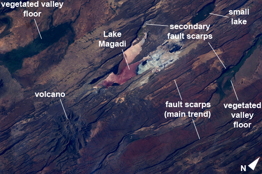
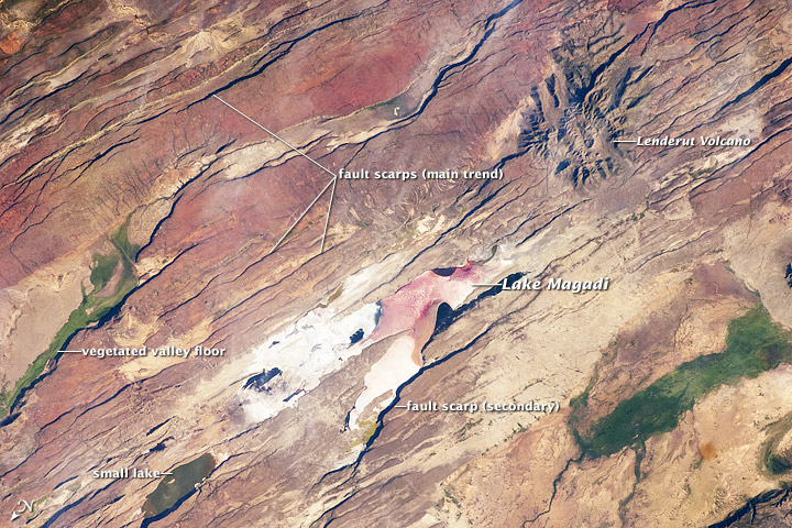
Image Caption: East African Rift Valley Features, Kenya
Note: This caption refers to the image versions labeled "NASA's Earth Observatory web site".
This astronaut photograph highlights classical geological structures associated with a tectonic rift valley, in this case the Eastern Branch of the East African Rift near Kenya's southern border with Tanzania and just south of the Equator. The East African Rift is one of the great tectonic features of Africa, caused by fracturing of the Earth's crust. The Nubian (or African) plate includes the older continental crust of Africa to the west, while the Somalian plate that is moving away includes the Horn of Africa. Together with the associated Ethiopian Rift to the northeast, the tectonic boundary stretches from the southern Red Sea to central Mozambique.
Landscapes in the rift valley can appear confusing. The most striking features in this view are the numerous, nearly parallel, linear fault lines that occupy the floor of the valley (most of the image). Shadows cast by the late afternoon sun make the fault scarps (steps in the landscape caused by slip motion along individual faults) more prominent. The faults are aligned with the north-south axis of the valley (image lower left to top right). A secondary trend of less linear faults cuts the main fault trend at an acute angle, the fault steps throwing large shadows.
The Eastern Branch of the East African Rift is arid (compared with the Western Branch which lies on the border of the Congolese rainforest). Evidence of this can be seen in the red, salt-loving algae of the shallow and salty Lake Magadi (image center). A neighboring small lake to the north has deeper water and appears dark in the image. The white salt deposits of the dry part of the Lake Magadi floor (image center) host a few small commercial salt pans. The lakes appear to be located where the main and secondary fault trends intersect.
The East African rift system is marked by substantial volcanic activity, including lavas erupted from fissures along the rift in the region. Much of the faulting observed in this image cuts through such lavas. Elsewhere along the rift system individual volcanoes form. Some of those volcanoes are very large, including Mt. Kilimanjaro and Mt. Kenya. In this image, rising 400 m above the valley floor, a volcano appears to be superimposed on the faults--indicating that the volcano is younger than the faults it covers. Deeply eroded slopes also suggest that the volcano has not been active for a long time. The largest vegetated area (image top right)--in an desert zone with no vegetation visible to the naked eye from space--is the green floor of a valley which drains an area large enough for water to exist near the surface so that plants can thrive. For a sense of scale, the vegetated valley floor is 17 km long (10.5 miles).
