ISS028-E-14970
| NASA Photo ID | ISS028-E-14970 |
| Focal Length | 28mm |
| Date taken | 2011.07.08 |
| Time taken | 08:11:07 GMT |


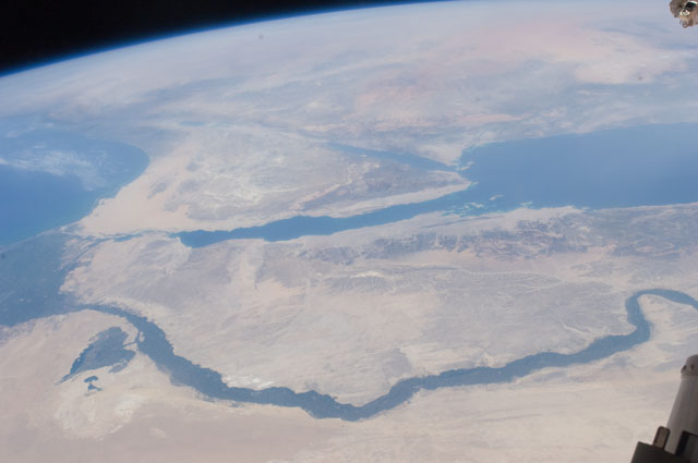
Spacecraft nadir point: 25.2° N, 27.2° E
Photo center point: 29.0° N, 33.5° E
Photo center point by machine learning:
Photo center point: 29.0° N, 33.5° E
Photo center point by machine learning:
Nadir to Photo Center: Northeast
Spacecraft Altitude: 208 nautical miles (385km)
Country or Geographic Name: | EGYPT |
Features: | PAN-SINAI PEN., N. RED S., NILE R. V., G. OF SUEZ, G. OF AQABA, HAZE, ISS |
| Features Found Using Machine Learning: | PAN- |
Cloud Cover Percentage: | 10 (1-10)% |
Sun Elevation Angle: | 61° |
Sun Azimuth: | 88° |
Camera: | Nikon D2Xs Electronic Still Camera |
Focal Length: | 28mm |
Camera Tilt: | High Oblique |
Format: | 4288E: 4288 x 2848 pixel CMOS sensor, RGBG imager color filter |
Film Exposure: | |
| Additional Information | |
| Width | Height | Annotated | Cropped | Purpose | Links |
|---|---|---|---|---|---|
| 4288 pixels | 2848 pixels | No | No | Download Image | |
| 640 pixels | 425 pixels | No | No | Download Image |
Download Packaged File
Download a Google Earth KML for this Image
View photo footprint information
Download a GeoTIFF for this photo
Image Caption: ISS028-E-014970 (10 July 2011) --- One of the crewmembers aboard the International Space Station recorded this oblique view showing the Nile River Delta and the Sinai Peninsula, with a 28 millimeter lens. The Mediterranean Coast is at far left.
