ISS027-E-11058

| NASA Photo ID | ISS027-E-11058 |
| Focal Length | 400mm |
| Date taken | 2011.04.09 |
| Time taken | 14:53:40 GMT |
Resolutions offered for this image:
1000 x 1507 pixels 540 x 814 pixels 720 x 480 pixels 4288 x 2929 pixels 640 x 437 pixels
1000 x 1507 pixels 540 x 814 pixels 720 x 480 pixels 4288 x 2929 pixels 640 x 437 pixels
Cloud masks available for this image:
Spacecraft nadir point: 31.7° S, 59.0° W
Photo center point: 29.2° S, 59.4° W
Photo center point by machine learning:
Photo center point: 29.2° S, 59.4° W
Photo center point by machine learning:
Nadir to Photo Center: North
Spacecraft Altitude: 192 nautical miles (356km)
Country or Geographic Name: | ARGENTINA |
Features: | PARANA R., FLOODPLAIN MEANDERS, LAKES |
| Features Found Using Machine Learning: | |
Cloud Cover Percentage: | 10 (1-10)% |
Sun Elevation Angle: | 48° |
Sun Azimuth: | 24° |
Camera: | Nikon D2Xs Electronic Still Camera |
Focal Length: | 400mm |
Camera Tilt: | 38 degrees |
Format: | 4288E: 4288 x 2848 pixel CMOS sensor, RGBG imager color filter |
Film Exposure: | |
| Additional Information | |
| Width | Height | Annotated | Cropped | Purpose | Links |
|---|---|---|---|---|---|
| 1000 pixels | 1507 pixels | No | Yes | Earth From Space collection | Download Image |
| 540 pixels | 814 pixels | Yes | Yes | Earth From Space collection | Download Image |
| 720 pixels | 480 pixels | Yes | Yes | NASA's Earth Observatory web site | Download Image |
| 4288 pixels | 2929 pixels | No | No | Download Image | |
| 640 pixels | 437 pixels | No | No | Download Image |
Download Packaged File
Download a Google Earth KML for this Image
View photo footprint information
Download a GeoTIFF for this photo
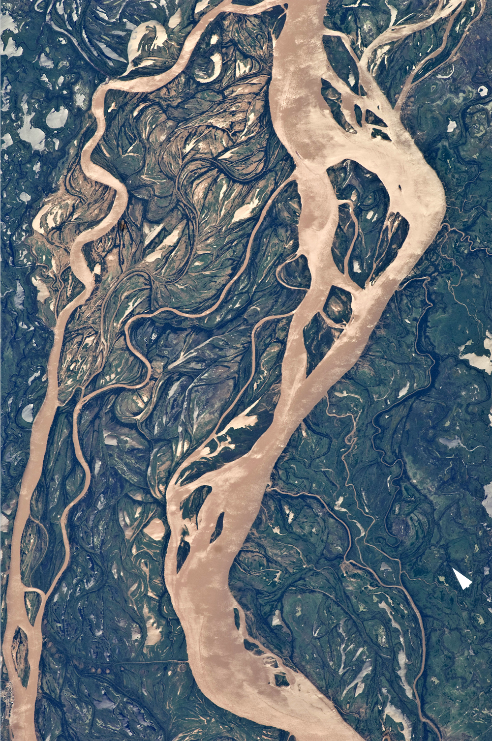
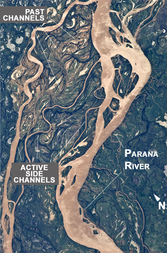
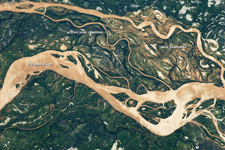
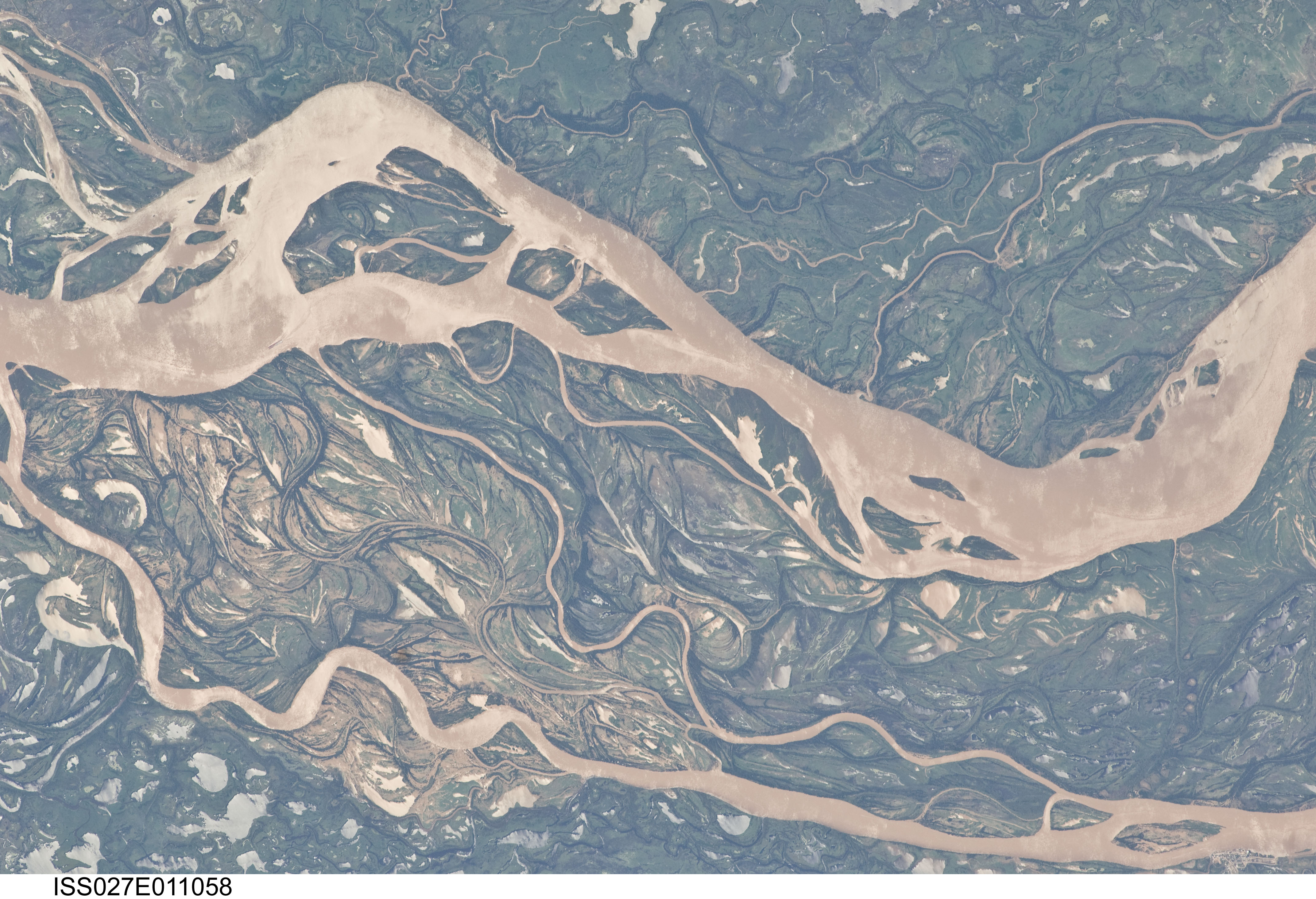
Image Caption: Parana River Floodplain, Northern Argentina
Note: This caption refers to the image versions labeled "NASA's Earth Observatory web site".
This astronaut photograph shows a 29-km stretch of the Parana River, South America's second largest river, downstream of the small city of Goya (barely distinguishable as grayer surfaces in the extreme top right corner of the image). The Parana River ranges up to 3 km wide along the reach illustrated in the image. Its strong brown color indicates that it is carrying a heavy load of muddy sediment. Smaller active side channels also carry this muddy water. Numerous lakes are typical on active floodplains, and appear here as irregular bodies of water. Some appear brown, indicating that they have been refilled during recent higher flood levels of the active channels.
The main channel Parana River (image right) is deep enough to allow smaller ocean-going ships to pass north of the illustrated region to the capital city of Asuncion in landlocked Paraguay, fully 1200 km inland (well out of the image). The Parana River is thus an important transportation route for landlocked cities such as Asuncion and inland cities of eastern landlocked Bolivia and inland Brazil.
The Parana floodplain occupies the entire image; it is so wide--18 km in this view--that its banks are not visible. Numerous curved, or meandering past channels are the most prominent characteristic of the floodplain. These indicate prior positions of rivers. As river beds move laterally by natural processes, they leave remnants of their channels, which appear as lakes, and finally fill with mud. This is an excellent image for illustrating these meander forms. Other astronaut photographs are available showing more examples of strong meandering--on the Rio Negro of southern Argentina, the Marmore River of Bolivia, and the Amazon River of western Brazil.
From a geological standpoint it is interesting that almost all the past channels are similar in curvature to the smaller active side rivers; almost no forms show, in any obvious way, prior positions of the main, very wide Parana channel. The reverse might be expected since the main channel is so dominant in the modern landscape.
