ISS026-E-6255

| NASA Photo ID | ISS026-E-6255 |
| Focal Length | 180mm |
| Date taken | 2010.11.30 |
| Time taken | 12:06:00 GMT |
Resolutions offered for this image:
1000 x 679 pixels 540 x 367 pixels 720 x 540 pixels 4256 x 2913 pixels 640 x 438 pixels
1000 x 679 pixels 540 x 367 pixels 720 x 540 pixels 4256 x 2913 pixels 640 x 438 pixels


Cloud masks available for this image:
Spacecraft nadir point: 40.0° N, 110.1° W
Photo center point: 36.1° N, 115.2° W
Photo center point by machine learning:
Photo center point: 36.1° N, 115.2° W
Photo center point by machine learning:
Nadir to Photo Center: Southwest
Spacecraft Altitude: 189 nautical miles (350km)
Country or Geographic Name: | USA-NEVADA |
Features: | LAS VEGAS AT NIGHT, CITY LIGHTS, MCCARRAN AIRPORT |
| Features Found Using Machine Learning: | |
Cloud Cover Percentage: | 0 (no clouds present) |
Sun Elevation Angle: | -25° |
Sun Azimuth: | 98° |
Camera: | Nikon D3S Electronic Still Camera |
Focal Length: | 180mm |
Camera Tilt: | High Oblique |
Format: | 4256E: 4256 x 2832 pixel CMOS sensor, 36.0mm x 23.9mm, total pixels: 12.87 million, Nikon FX format |
Film Exposure: | |
| Additional Information | |
| Width | Height | Annotated | Cropped | Purpose | Links |
|---|---|---|---|---|---|
| 1000 pixels | 679 pixels | No | Yes | Earth From Space collection | Download Image |
| 540 pixels | 367 pixels | Yes | Yes | Earth From Space collection | Download Image |
| 720 pixels | 540 pixels | Yes | Yes | NASA's Earth Observatory web site | Download Image |
| 4256 pixels | 2913 pixels | No | No | Download Image | |
| 640 pixels | 438 pixels | No | No | Download Image |
Download Packaged File
Download a Google Earth KML for this Image
View photo footprint information
Download a GeoTIFF for this photo
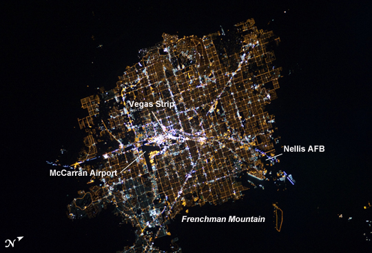
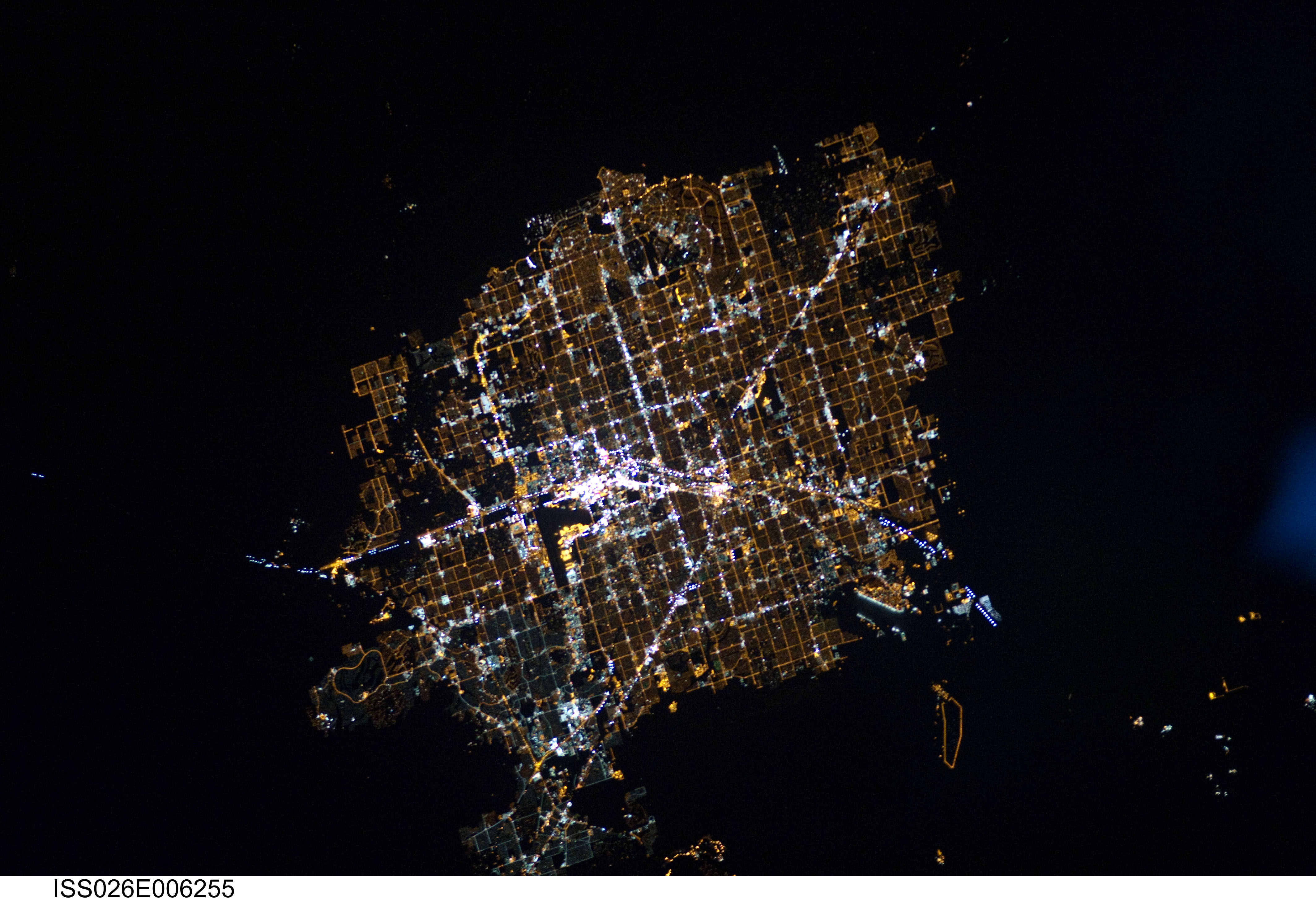
Image Caption: Las Vegas at Night
The Las Vegas metropolitan area is located near the southern tip of Nevada, within the Mohave Desert. While the city is famous for its casinos and resort hotels--Las Vegas bills itself as "the entertainment capital of the world"--the wider metropolitan area includes several other incorporated cities and unincorporated areas (not part of a state-recognized municipality).
Astronauts on the International Space Station (ISS) observe and photograph numerous metropolitan areas when they are illuminated by sunlight, but the extent and pattern of these areas is perhaps best revealed at night by city lights. The surrounding darkness of the desert presents a stark contrast to the brightly lit street grid of the developed area. The Vegas Strip is reputed to be the brightest spot on Earth due to the concentration of lights on its hotels and casinos. The tarmac of McCarran International Airport is dark by comparison, while the airstrips of Nellis Air Force Base on the northeastern fringe are likewise dark. The dark mass of Frenchman Mountain borders the city to the east.
The acquisition of focused nighttime images requires astronauts to track the target with the handheld camera while the ISS is moving at a speed of more than 7 kilometers per second (over 15,000 miles per hour) relative to the Earth's surface. This was achieved during ISS Expedition 6 using a homemade tracking device, but subsequent crews have needed to develop manual tracking skills. These skills, together with advances in digital camera technology, have enabled recent ISS crews to acquire striking nighttime images of the Earth (such as this recent image of the Nile River Delta).
