ISS026-E-26761
| NASA Photo ID | ISS026-E-26761 |
| Focal Length | 800mm |
| Date taken | 2011.02.13 |
| Time taken | 20:29:33 GMT |
Resolutions offered for this image:
1000 x 661 pixels 540 x 357 pixels 720 x 480 pixels 4288 x 2929 pixels 640 x 437 pixels
1000 x 661 pixels 540 x 357 pixels 720 x 480 pixels 4288 x 2929 pixels 640 x 437 pixels
Cloud masks available for this image:
Spacecraft nadir point: 39.4° S, 57.7° W
Photo center point: 38.7° S, 59.1° W
Photo center point by machine learning:
Photo center point: 38.7° S, 59.1° W
Photo center point by machine learning:
Nadir to Photo Center: West
Spacecraft Altitude: 190 nautical miles (352km)
Country or Geographic Name: | ARGENTINA |
Features: | SAND DUNES, AGRICULTURAL FIELDS, MEDANO BLANCO, ATLANTIC OCEAN |
| Features Found Using Machine Learning: | |
Cloud Cover Percentage: | 10 (1-10)% |
Sun Elevation Angle: | 27° |
Sun Azimuth: | 275° |
Camera: | Nikon D2Xs Electronic Still Camera |
Focal Length: | 800mm |
Camera Tilt: | 26 degrees |
Format: | 4288E: 4288 x 2848 pixel CMOS sensor, RGBG imager color filter |
Film Exposure: | |
| Additional Information | |
| Width | Height | Annotated | Cropped | Purpose | Links |
|---|---|---|---|---|---|
| 1000 pixels | 661 pixels | No | Yes | Earth From Space collection | Download Image |
| 540 pixels | 357 pixels | Yes | Yes | Earth From Space collection | Download Image |
| 720 pixels | 480 pixels | Yes | Yes | NASA's Earth Observatory web site | Download Image |
| 4288 pixels | 2929 pixels | No | No | Download Image | |
| 640 pixels | 437 pixels | No | No | Download Image |
Download Packaged File
Download a Google Earth KML for this Image
View photo footprint information
Download a GeoTIFF for this photo
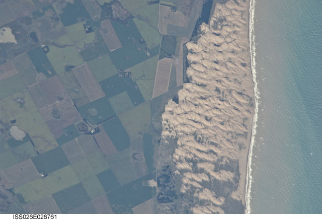
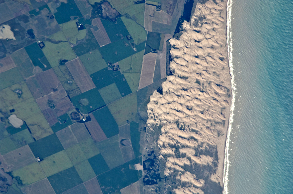
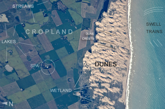
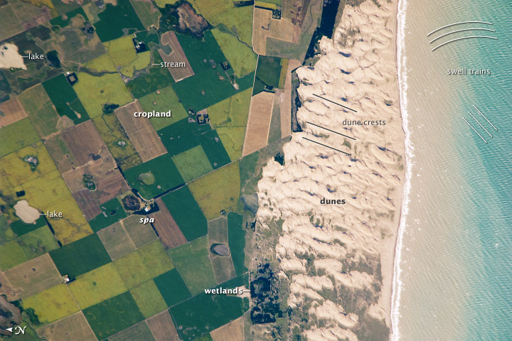
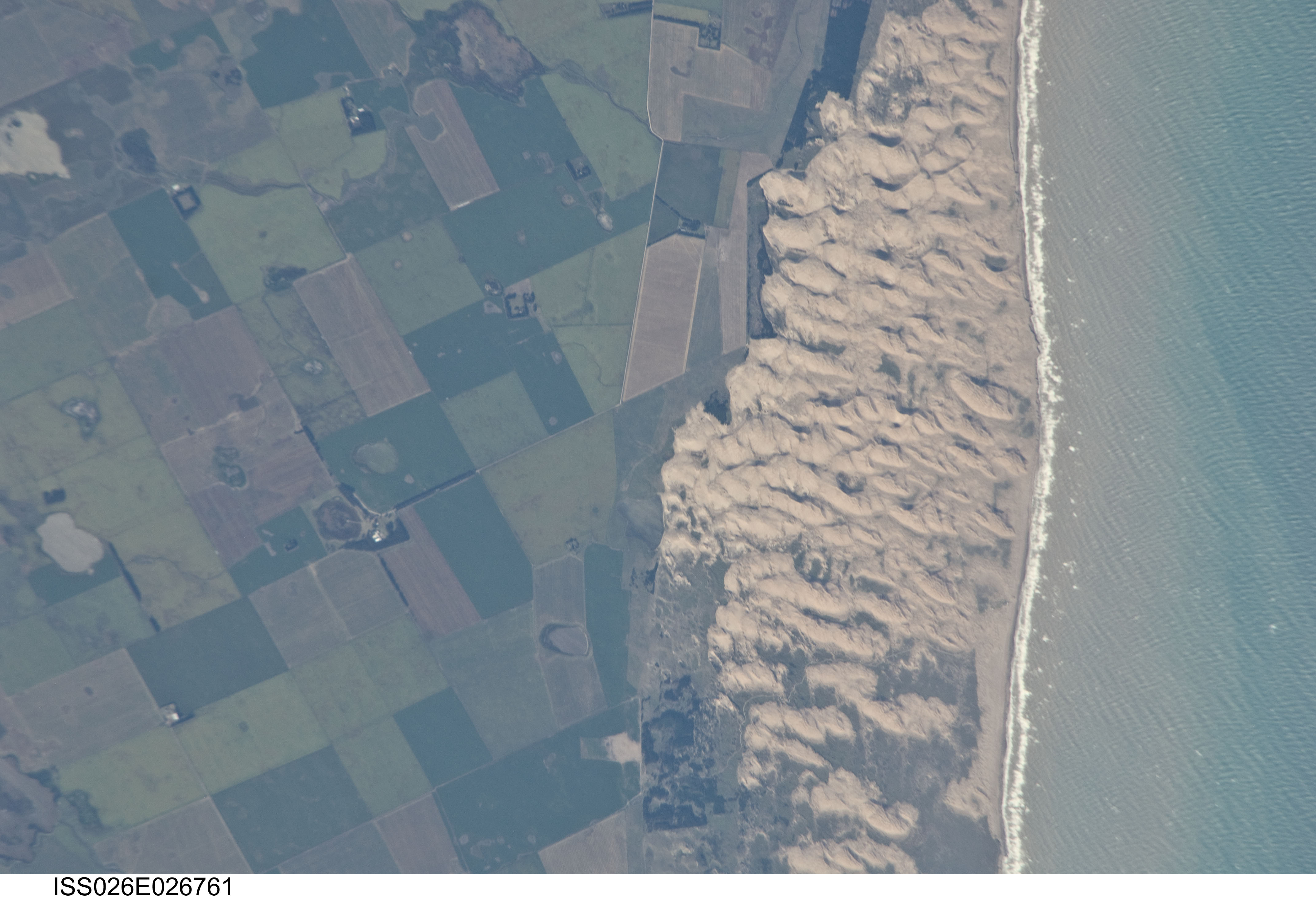
Image Caption: Medano Blanco coastal dunes, Buenos Aires Province, Argentina
The Medano Blanco (White Dunes) are a well known recreational area 35 km west of the twin cities of Nicochea-Quequen, one of the biggest ports in the province of Buenos Aires, central Argentina. The Medano Blanco dunes separate the Atlantic Ocean from intensive sunflower agricultural cropland, visible as the angular pattern of green and brown fields at image left. The dune field extends 3.5 km at its widest part. Narrow cordons of coastal dunes stretch along this part of Argentina's coastline for hundreds of km. Small streams, oriented towards the coast, cross the farmland at image upper left. Water from these is dammed behind the dunes, and even within the dunes, where wetlands flourish.
This is the drier southern part of Buenos Aires province near the more arid and windier border with Patagonia--one of the windiest places on Earth. The effect of strong westerly winds (blowing bottom to top in this slightly oblique image) can be seen everywhere in this detailed astronaut photograph. The dune sand is blown from local beaches onshore where it forms the dunes. The prominent dune ridge crests are oriented at right angles to the prevailing wind. Geologists suspect that erosion by wind has excavated numerous hollows which now dot the farmland as small shallow lakes, seen here with more and less water. A stand of dark green trees has been planted on the upwind side of a health spa--located at the white dot (image center left) which is the roof of a stately building--as a protective barrier against the wind.
The white fringe along the seashore is formed from lines of breaking waves. Crossing swell trains can be seen offshore in the Atlantic Ocean. The curvature of the swell pattern offshore also shows the effect of the westerly wind, and indeed drives the local sea current in this area--slightly more prominent onshore swells approach the coast from the southeast. The light brown tint of seawater nearer the shore is the fine muddy fraction of the coastal sediment being washed seaward (after being stirred up by wave action) and then east by the current.
