ISS026-E-12474
| NASA Photo ID | ISS026-E-12474 |
| Focal Length | 180mm |
| Date taken | 2010.12.24 |
| Time taken | 06:36:14 GMT |
Resolutions offered for this image:
1000 x 692 pixels 540 x 374 pixels 720 x 480 pixels 4256 x 2913 pixels 640 x 438 pixels
1000 x 692 pixels 540 x 374 pixels 720 x 480 pixels 4256 x 2913 pixels 640 x 438 pixels

Cloud masks available for this image:
Spacecraft nadir point: 41.9° N, 79.1° W
Photo center point: 45.5° N, 73.8° W
Photo center point by machine learning: 45.54° N, 73.76° W
Photo center point: 45.5° N, 73.8° W
Photo center point by machine learning: 45.54° N, 73.76° W
Nadir to Photo Center: Northeast
Spacecraft Altitude: 187 nautical miles (346km)

Country or Geographic Name: | CANADA-Q |
Features: | MONTREAL AT NIGHT |
| Features Found Using Machine Learning: | |
Cloud Cover Percentage: | 10 (1-10)% |
Sun Elevation Angle: | -65° |
Sun Azimuth: | 49° |
Camera: | Nikon D3S Electronic Still Camera |
Focal Length: | 180mm |
Camera Tilt: | High Oblique |
Format: | 4256E: 4256 x 2832 pixel CMOS sensor, 36.0mm x 23.9mm, total pixels: 12.87 million, Nikon FX format |
Film Exposure: | |
| Additional Information | |
| Width | Height | Annotated | Cropped | Purpose | Links |
|---|---|---|---|---|---|
| 1000 pixels | 692 pixels | No | Yes | Earth From Space collection | Download Image |
| 540 pixels | 374 pixels | Yes | Yes | Earth From Space collection | Download Image |
| 720 pixels | 480 pixels | Yes | Yes | NASA's Earth Observatory web site | Download Image |
| 4256 pixels | 2913 pixels | No | No | Download Image | |
| 640 pixels | 438 pixels | No | No | Download Image |
Download Packaged File
Download a Google Earth KML for this Image
View photo footprint information
Download a GeoTIFF for this photo
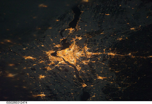
Image Caption: Montreal at Night
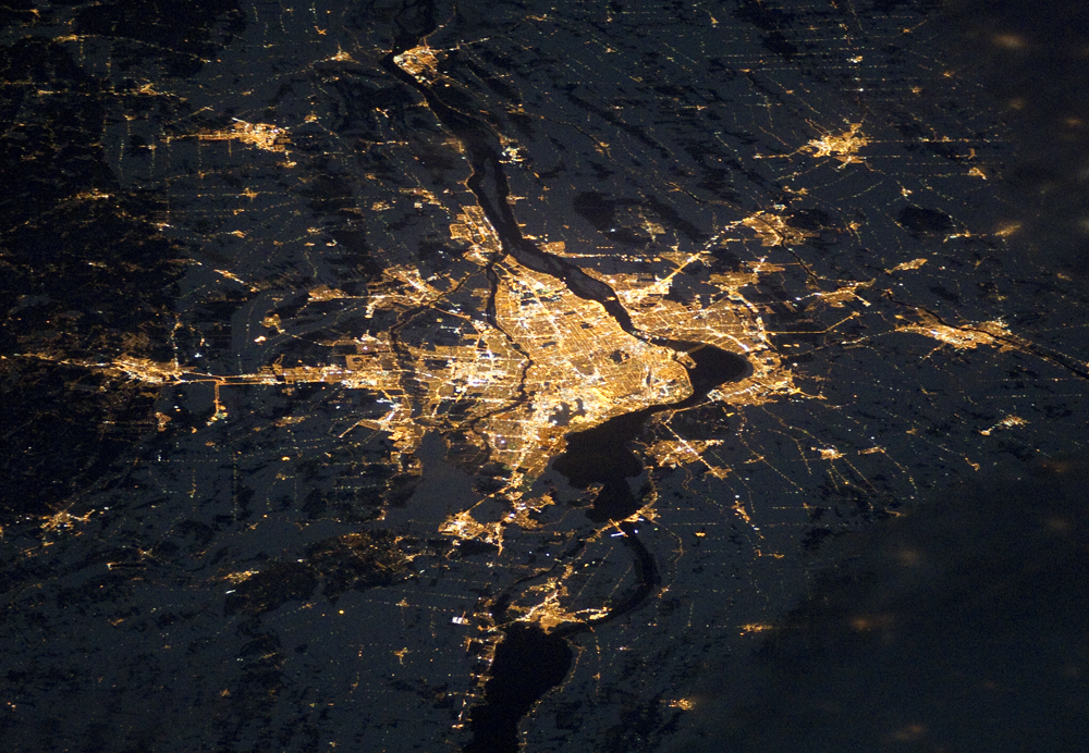
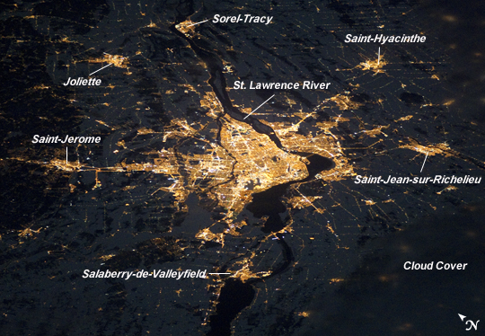
Note: This caption refers to the image versions labeled "NASA's Earth Observatory web site". As this image was taken by an astronaut in an upside-down orientation relative to the look direction of the camera, the Earth Observatory images have been rotated 180 degrees in order to visually agree with the known ISS ground track location at the time of image acquisition.
Montreal, the largest city in the mostly French-speaking Province of Quebec, is considered by some to be the cultural capital of Canada. The metropolitan area (image center) is the country's second-largest, having been surpassed by Toronto in 1976. While the city of Montreal is located on the Island of Montreal, at the confluence of the St. Lawrence (image center) and Ottawa rivers (not visible), the city takes its name from Mont Royal, located at the city's center. Several smaller urban areas form a loose ring around the metropolitan area: Sorel-Tracy, Saint-Hyacinthe, Saint-Jean-sur-Richelieu, Salaberry-de-Valleyfield, Saint-Jerome, and Joliette are among those that can be readily identified.
This astronaut photograph of the city lights of Montreal illustrates the extent of urbanization. Major roadways and industrial areas are traced by bright white lighting, while the adjacent residential and commercial lands are characterized by more diffuse yellow-gold lighting. Rivers and other water bodies appear black, while the surrounding countryside is faintly illuminated by moonlight. Blurry areas at image top and bottom right are caused by cloud cover.
The International Space Station was located over the Pennsylvania-New York border (near Warren, Pa.) at the time this image was taken--a ground distance of approximately 600 kilometers (370 miles) southwest of Montreal. This distance from the camera target, coupled with the oblique (inclined) viewing angle from the ISS, results in the foreshortened appearance of urban areas in the image.
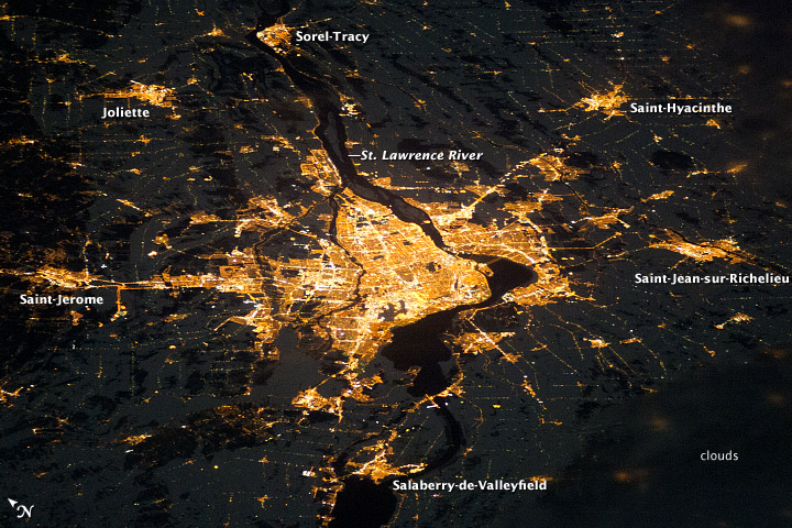
