ISS025-E-17440
| NASA Photo ID | ISS025-E-17440 |
| Focal Length | 800mm |
| Date taken | 2010.11.19 |
| Time taken | 23:02:14 GMT |
Resolutions offered for this image:
1000 x 664 pixels 540 x 359 pixels 720 x 480 pixels 4256 x 2913 pixels 640 x 438 pixels
1000 x 664 pixels 540 x 359 pixels 720 x 480 pixels 4256 x 2913 pixels 640 x 438 pixels
Cloud masks available for this image:
Spacecraft nadir point: 48.7° N, 172.8° E
Photo center point: 54.8° N, 160.5° E
Photo center point by machine learning:
Photo center point: 54.8° N, 160.5° E
Photo center point by machine learning:
Nadir to Photo Center: West
Spacecraft Altitude: 188 nautical miles (348km)
Country or Geographic Name: | RUSSIAN FEDERATION |
Features: | LAKE KRONOTSKOE, KRONOTSKY VOLCANO, KRASHENINNIKOV VOLCANO, SCHMIDT VOLCANO |
| Features Found Using Machine Learning: | |
Cloud Cover Percentage: | 10 (1-10)% |
Sun Elevation Angle: | 20° |
Sun Azimuth: | 162° |
Camera: | Nikon D3S Electronic Still Camera |
Focal Length: | 800mm |
Camera Tilt: | High Oblique |
Format: | 4256E: 4256 x 2832 pixel CMOS sensor, 36.0mm x 23.9mm, total pixels: 12.87 million, Nikon FX format |
Film Exposure: | |
| Additional Information | |
| Width | Height | Annotated | Cropped | Purpose | Links |
|---|---|---|---|---|---|
| 1000 pixels | 664 pixels | No | Yes | Earth From Space collection | Download Image |
| 540 pixels | 359 pixels | Yes | Yes | Earth From Space collection | Download Image |
| 720 pixels | 480 pixels | Yes | Yes | NASA's Earth Observatory web site | Download Image |
| 4256 pixels | 2913 pixels | No | No | Download Image | |
| 640 pixels | 438 pixels | No | No | Download Image |
Download Packaged File
Download a Google Earth KML for this Image
View photo footprint information
Download a GeoTIFF for this photo
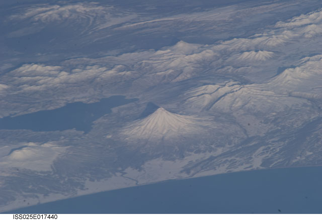
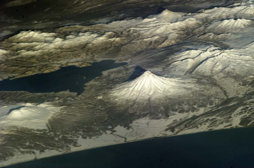
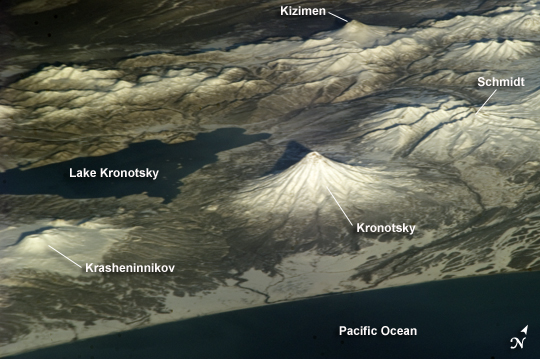
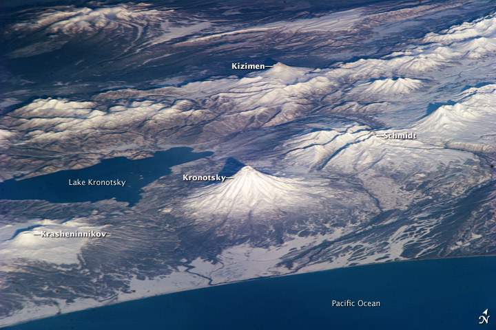
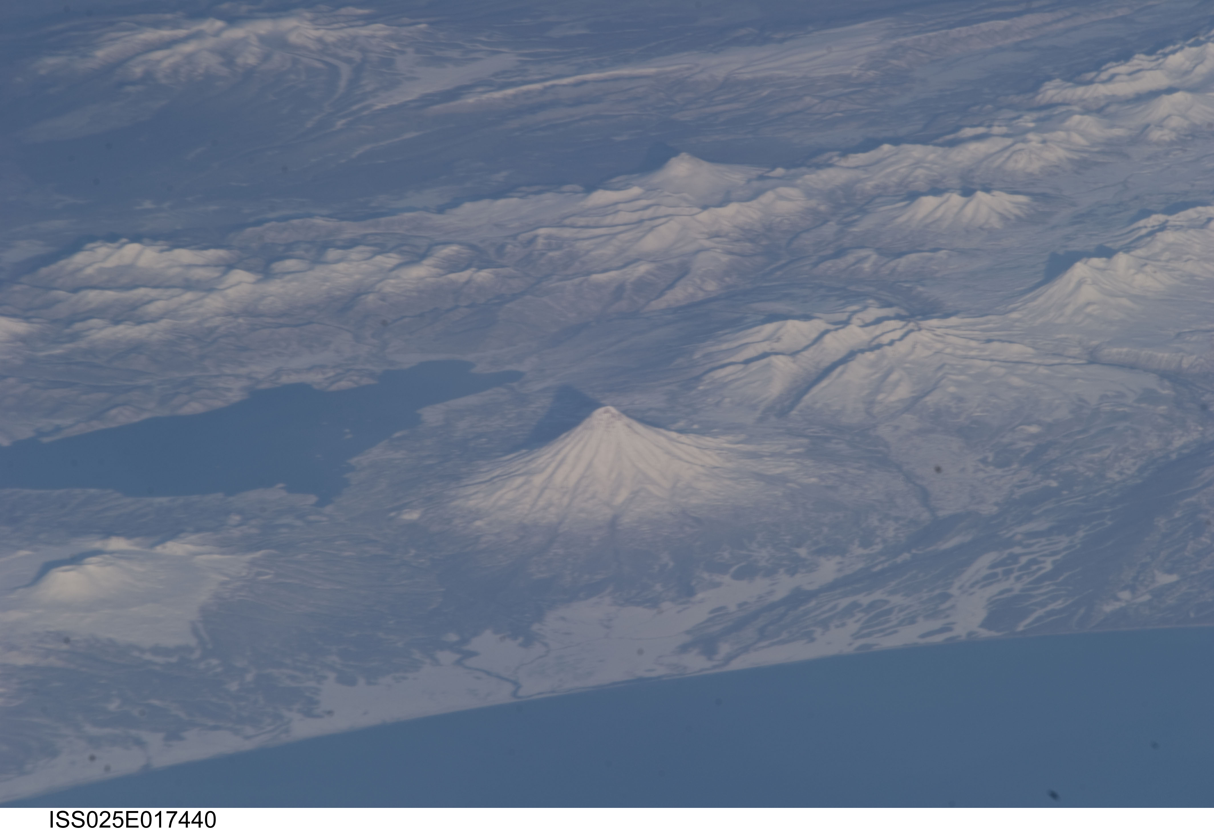
Image Caption: Kamchatka Volcanoes
This astronaut photograph of snow-covered volcanoes on Russia's Kamchatka Peninsula illustrates one of the unique attributes of the International Space Station-- the ability to view landscapes at an angle, rather than the straight-down view typical of many satellite-based sensors. This oblique view, together with shadows cast by the volcanoes and mountains, provides perspective about the topography of the region.
Kronotsky and Kizimen stratovolcanoes are distinguished by their symmetrical cones. Kizimen last erupted in 1928, while Kronotsky--one of the largest on the peninsula--last erupted in 1923.
Schmidt Volcano, to the north of Kronotsky, has the morphology of a shield volcano and is not known to have erupted since humans have been keeping records.
To the south (left) is Krasheninnikov, comprised of overlapping stratovolcanoes that formed within an earlier caldera. Krasheninnikov may have last erupted in 1550. Two summit craters are clearly visible.
Lake Kronotsky is Kamchatka's largest lake. It formed when lava flows from Kronotsky Volcano dammed the Listvenichnaya River.
The Kamchatka Peninsula lies along the so-called Pacific "Ring of Fire." The ring is characterized by active volcanoes and frequent earthquakes associated with the many active subduction and transform boundary zones around the Pacific tectonic plate. There are 114 volcanoes on the Kamchatka Peninsula that have erupted during the Holocene Epoch (approximately 12,000 years ago to the present).
