ISS025-E-13475

| NASA Photo ID | ISS025-E-13475 |
| Focal Length | 16mm |
| Date taken | 2010.11.09 |
| Time taken | 17:20:47 GMT |


Spacecraft nadir point: 24.2° N, 82.3° W
Photo center point: 24.5° N, 80.0° W
Photo center point by machine learning:
Photo center point: 24.5° N, 80.0° W
Photo center point by machine learning:
Nadir to Photo Center: East
Spacecraft Altitude: 191 nautical miles (354km)
Country or Geographic Name: | USA-FLORIDA |
Features: | FLORIDA EVERGLADES, ANDROS IS., GRAND BAHAMA IS., CUPOLA WINDOW |
| Features Found Using Machine Learning: | |
Cloud Cover Percentage: | 25 (11-25)% |
Sun Elevation Angle: | 49° |
Sun Azimuth: | 183° |
Camera: | Nikon D2Xs Electronic Still Camera |
Focal Length: | 16mm |
Camera Tilt: | 36 degrees |
Format: | 4288E: 4288 x 2848 pixel CMOS sensor, RGBG imager color filter |
Film Exposure: | |
| Additional Information | |
| Width | Height | Annotated | Cropped | Purpose | Links |
|---|---|---|---|---|---|
| 2929 pixels | 4288 pixels | No | No | Download Image | |
| 437 pixels | 640 pixels | No | No | Download Image |
Download Packaged File
Download a Google Earth KML for this Image
View photo footprint information
Download a GeoTIFF for this photo
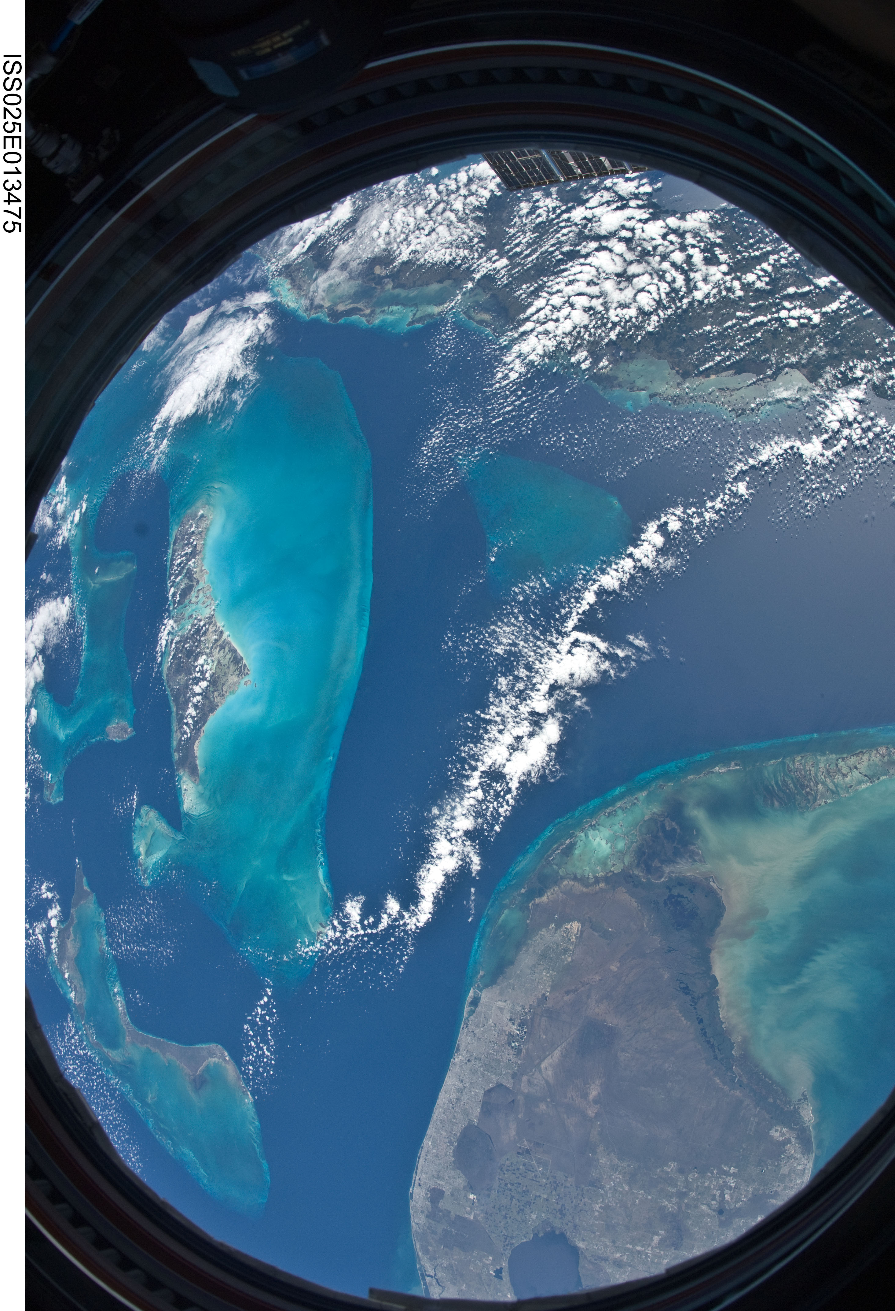
Image Caption: ISS025-E-013475 (9 Nov. 2010) --- Parts of the Atlantic, Gulf of Mexico and Caribbean Sea are easily noted in this unusual circular shaped image exposed by one of the Expedition 25 crew members aboard the International Space Station 220 miles above Earth. A 16mm f/2.8D lens gives this image a fish-eye effect, and the frame of the Cupola window adds to the circular shape. The southern portion of the Florida peninsula, including the elongated metropolitan Miami area, Lake Okeechobee and the Florda Keys, lies just a few kilometers away from islands in the Bahamas chain and the "Tongue of the Ocean." Andros is the largest visible island to the left of center.
