ISS023-E-22411
| NASA Photo ID | ISS023-E-22411 |
| Focal Length | 340mm |
| Date taken | 2010.03.31 |
| Time taken | 22:29:27 GMT |
Resolutions offered for this image:
1000 x 678 pixels 540 x 366 pixels 720 x 480 pixels 6048 x 4147 pixels 640 x 439 pixels
1000 x 678 pixels 540 x 366 pixels 720 x 480 pixels 6048 x 4147 pixels 640 x 439 pixels

Cloud masks available for this image:
Spacecraft nadir point: 11.4° N, 88.5° W
Photo center point: 13.4° N, 88.3° W
Photo center point by machine learning:
Photo center point: 13.4° N, 88.3° W
Photo center point by machine learning:
Nadir to Photo Center: North
Spacecraft Altitude: 185 nautical miles (343km)
Country or Geographic Name: | EL SALVADOR |
Features: | SAN MIGUEL VOLCANO, CHINAMECA VOLCANO, EL TIGRE VOLCANO, USULUTAN VOLCANO |
| Features Found Using Machine Learning: | |
Cloud Cover Percentage: | 10 (1-10)% |
Sun Elevation Angle: | 23° |
Sun Azimuth: | 270° |
Camera: | Nikon D3X Electronic Still Camera |
Focal Length: | 340mm |
Camera Tilt: | 33 degrees |
Format: | 6048E: 6048 x 4032 pixel CMOS sensor, 35.9mm x 24.0mm, total pixels: 25.72 million, Nikon FX format |
Film Exposure: | |
| Additional Information | |
| Width | Height | Annotated | Cropped | Purpose | Links |
|---|---|---|---|---|---|
| 1000 pixels | 678 pixels | No | Yes | Earth From Space collection | Download Image |
| 540 pixels | 366 pixels | Yes | Yes | Earth From Space collection | Download Image |
| 720 pixels | 480 pixels | Yes | Yes | NASA's Earth Observatory web site | Download Image |
| 6048 pixels | 4147 pixels | No | No | Download Image | |
| 640 pixels | 439 pixels | No | No | Download Image |
Download Packaged File
Download a Google Earth KML for this Image
View photo footprint information
Download a GeoTIFF for this photo
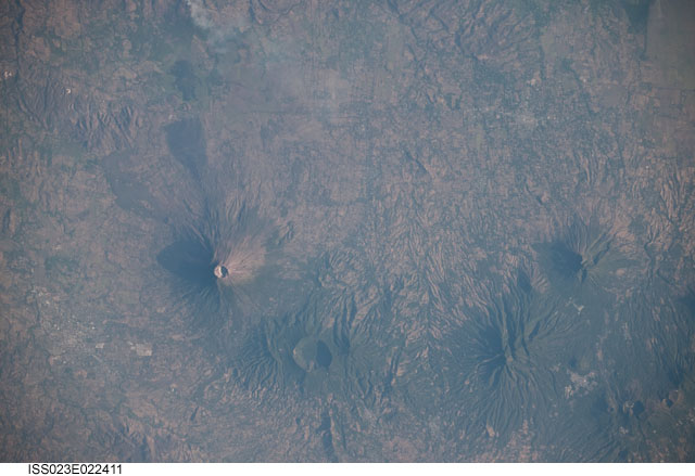
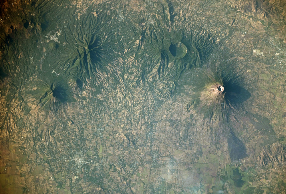
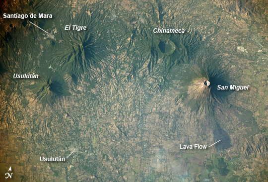
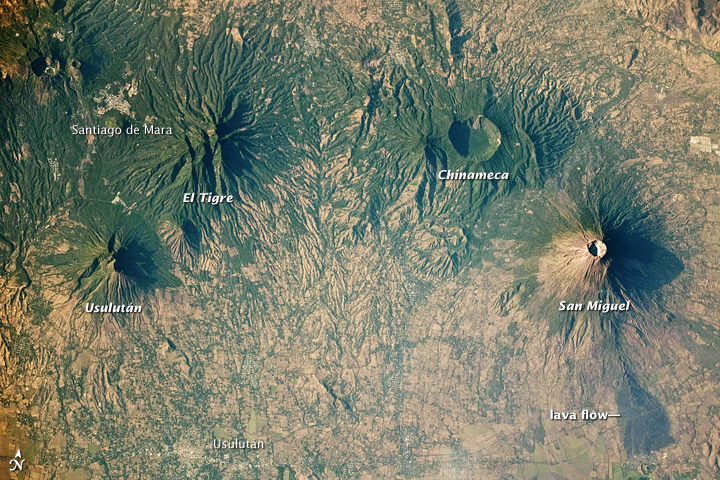
Image Caption: Volcanoes near Usulutan, El Salvador
The Pacific coastline of much of Central America is marked by a line of active and quiescent volcanoes known to geologists as the Central American Volcanic Arc. The volcanoes result from the upward movement of magma generated along the subduction zone between the Cocos and Caribbean tectonic plates. Frequent earthquakes also occur along the plate boundary. This astronaut photograph includes four stratovolcanoes--a type of volcano common in active subduction zones--in El Salvador, near the midpoint of the Central American Volcanic Arc.
While all of the volcanoes shown here have been active during the Holocene Epoch (from about 10,000 years ago to the present), only the 2,130-meter- (6,990-foot-) high San Miguel (also known as Chaparrastique) has been active during historical times. The most recent activity of San Miguel was a minor gas and ash emission in 2002. The stratovolcano's steep cone shape and well-developed summit crater are evident, along with dark lava flows. Immediately to the northwest, the truncated summit of Chinameca Volcano (also known as El Pacayal) is marked by a two-kilometer- (one-mile-) wide caldera. The caldera formed when a powerful eruption emptied the volcano's magma chamber, causing the chamber's roof to collapse. Like its neighbor San Miguel, Chinameca's slopes host coffee plantations.
Moving to the west, the eroded cone of El Tigre Volcano is visible. El Tigre formed during the Pleistocene Epoch (1.8 million to about 10,000 years ago), and it is likely the oldest of the stratovolcanoes in the image. Usulutan Volcano is directly southwest of El Tigre. While the flanks of Usulutan have been dissected by streams, the mountain still retains a summit crater that is breached on the eastern side. Several urban areas--recognizable as light gray to white regions contrasting with green vegetation and tan fallow agricultural fields--are located in the vicinity of these volcanoes, including the town of Usulutan (lower left) and Santiago de Mara (upper left).
