ISS021-E-15243
| NASA Photo ID | ISS021-E-15243 |
| Focal Length | 400mm |
| Date taken | 2009.10.25 |
| Time taken | 20:50:07 GMT |
Resolutions offered for this image:
1000 x 664 pixels 540 x 359 pixels 720 x 480 pixels 3072 x 2098 pixels 640 x 437 pixels
1000 x 664 pixels 540 x 359 pixels 720 x 480 pixels 3072 x 2098 pixels 640 x 437 pixels


Cloud masks available for this image:
Spacecraft nadir point: 50.5° S, 63.5° W
Photo center point: 49.9° S, 73.3° W
Photo center point by machine learning:
Photo center point: 49.9° S, 73.3° W
Photo center point by machine learning:
Nadir to Photo Center: West
Spacecraft Altitude: 186 nautical miles (344km)
Country or Geographic Name: | ARGENTINA |
Features: | UPSALA GLACIER, ICEBERGS, LAKE ARGENTINO, MORAINES |
| Features Found Using Machine Learning: | |
Cloud Cover Percentage: | 10 (1-10)% |
Sun Elevation Angle: | 20° |
Sun Azimuth: | 275° |
Camera: | Nikon D2Xs Electronic Still Camera |
Focal Length: | 400mm |
Camera Tilt: | High Oblique |
Format: | 4288E: 4288 x 2848 pixel CMOS sensor, RGBG imager color filter |
Film Exposure: | |
| Additional Information | |
| Width | Height | Annotated | Cropped | Purpose | Links |
|---|---|---|---|---|---|
| 1000 pixels | 664 pixels | No | Yes | Earth From Space collection | Download Image |
| 540 pixels | 359 pixels | Yes | Yes | Earth From Space collection | Download Image |
| 720 pixels | 480 pixels | Yes | Yes | NASA's Earth Observatory web site | Download Image |
| 3072 pixels | 2098 pixels | No | No | Download Image | |
| 640 pixels | 437 pixels | No | No | Download Image |
Download Packaged File
Download a Google Earth KML for this Image
View photo footprint information
Download a GeoTIFF for this photo
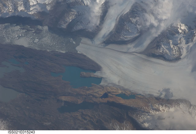
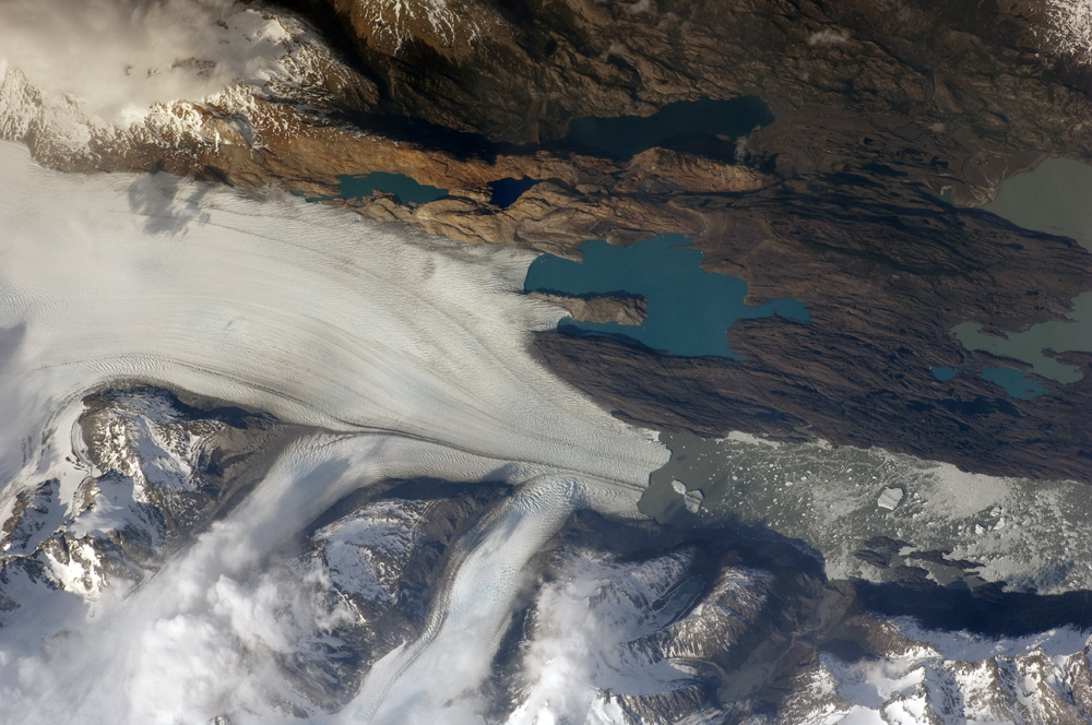
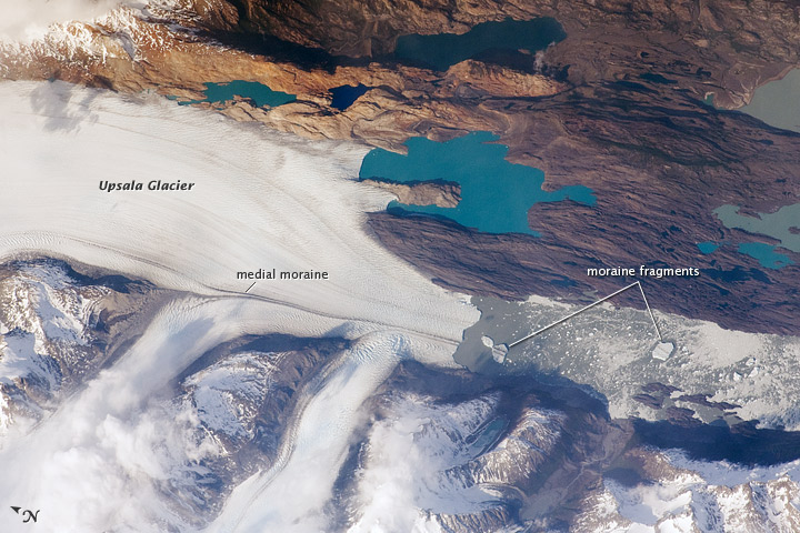
Image Caption: Upsala Glacier, Argentina
The Southern Patagonian Icefield of Argentina and Chile is the southern remnant of the Patagonia Ice Sheet that covered the southern Andes Mountains during the last ice age. This detailed astronaut photograph illustrates the terminus of one of the icefield's many spectacular glaciers--Upsala Glacier, located on the eastern side of the icefield. Upsala is the third largest glacier in the icefield, and like most other glaciers in the region, it has experienced significant retreat over the past century.
This image was taken during spring in the Southern Hemisphere, and icebergs were calving from the glacier terminus into the waters of Lago Argentino (Lake Argentina, image right). Two icebergs are especially interesting because they retain fragments of the moraine (rock debris) that forms a dark line along the upper surface of the glacier. The inclusion of the moraine illustrates how land-based rocks and sediment may wind up in ocean sediments far from shore.
Moraines are formed from rock and soil debris that accumulate along the front and sides of a flowing glacier. The glacier is like a bulldozer that pushes soil and rock in front of it, leaving debris on either side. When two glaciers merge (image center), moraines along their edges can join to form a medial moraine that is drawn out along the upper surface of the new glacier.
The moraine can be carried intact to the terminus and included in icebergs that then float away, dropping the coarse debris as the iceberg melts. While the icebergs produced by Upsala Glacier do not reach an ocean, many current glaciers do. The existence of ancient glaciers and ice sheets is recorded by layers or pockets of coarse, land-derived sediments within finer-grained sea floor sediments that are located far from any current (or former) coastline.
