ISS019-E-6499
| NASA Photo ID | ISS019-E-6499 |
| Focal Length | 400mm |
| Date taken | 2009.04.11 |
| Time taken | 13:01:18 GMT |
Resolutions offered for this image:
1000 x 608 pixels 540 x 328 pixels 720 x 480 pixels 4256 x 2913 pixels 640 x 438 pixels
1000 x 608 pixels 540 x 328 pixels 720 x 480 pixels 4256 x 2913 pixels 640 x 438 pixels


Cloud masks available for this image:
Spacecraft nadir point: 39.3° N, 33.3° E
Photo center point: 39.9° N, 32.9° E
Photo center point by machine learning:
Photo center point: 39.9° N, 32.9° E
Photo center point by machine learning:
Nadir to Photo Center: Northwest
Spacecraft Altitude: 188 nautical miles (348km)
Camera: | Nikon D2Xs Electronic Still Camera |
Focal Length: | 400mm |
Camera Tilt: | 13 degrees |
Format: | 4288E: 4288 x 2848 pixel CMOS sensor, RGBG imager color filter |
Film Exposure: | |
| Additional Information | |
| Width | Height | Annotated | Cropped | Purpose | Links |
|---|---|---|---|---|---|
| 1000 pixels | 608 pixels | No | Yes | Earth From Space collection | Download Image |
| 540 pixels | 328 pixels | Yes | Yes | Earth From Space collection | Download Image |
| 720 pixels | 480 pixels | Yes | Yes | NASA's Earth Observatory web site | Download Image |
| 4256 pixels | 2913 pixels | No | No | Download Image | |
| 640 pixels | 438 pixels | No | No | Download Image |
Download Packaged File
Download a Google Earth KML for this Image
View photo footprint information
Download a GeoTIFF for this photo
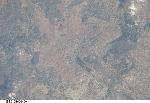
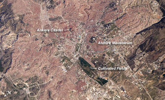
Image Caption: Ankara, Turkey
The central portion of the capital city of Turkey, Ankara, is featured in this astronaut photograph. Ankara is located in central Turkey. The climate there is continental and relatively dry, leading to cold winters and hot summers. The region is prone to major earthquakes, as Turkey experiences tectonic forces from both the African plate to the west and the Arabian plate to the east. Despite the earthquake hazard, the city traces its roots back into antiquity, with a Hittite settlement here prior to 1200 BC. A citadel built and occupied in turn by the Galatians, Romans, Byzantines, and Seljuks overlooks the central portion of the city, and today serves as both a historical and recreational site. Perhaps an even more imposing structure--the mausoleum of the founder of the modern-day Republic of Turkey, Mustafa Kemal Ataturk--is visible on an adjacent hill to the southwest.
Hill slopes around the city (image left and right) are fairly green due to spring rainfall. One of the most striking aspects of the urban area is the almost uniform use of red brick roofing tiles, which contrast with lighter-colored roads; the contrast is particularly evident in the northern (image lower left) and southern (image upper right) portions of the city. Numerous parks are visible as green patches interspersed within the red-roofed urban region. A region of cultivated fields in the western portion of the city (image center) is a recreational farming area known as the Ataturk Forest Farm and Zoo--an interesting example of intentional preservation of a former land use within an urban area.
