ISS019-E-5501

| NASA Photo ID | ISS019-E-5501 |
| Focal Length | 180mm |
| Date taken | 2009.04.09 |
| Time taken | 08:52:37 GMT |
Resolutions offered for this image:
1000 x 687 pixels 540 x 371 pixels 720 x 480 pixels 4288 x 2929 pixels 640 x 437 pixels
1000 x 687 pixels 540 x 371 pixels 720 x 480 pixels 4288 x 2929 pixels 640 x 437 pixels


Cloud masks available for this image:
Spacecraft nadir point: 44.0° N, 18.2° E
Photo center point: 43.5° N, 16.5° E
Photo center point by machine learning:
Photo center point: 43.5° N, 16.5° E
Photo center point by machine learning:
Nadir to Photo Center: West
Spacecraft Altitude: 190 nautical miles (352km)
Country or Geographic Name: | CROATIA |
Features: | SPLIT, BRACKI CHAN., MTS., ROADS |
| Features Found Using Machine Learning: | |
Cloud Cover Percentage: | 10 (1-10)% |
Sun Elevation Angle: | 46° |
Sun Azimuth: | 136° |
Camera: | Nikon D2Xs Electronic Still Camera |
Focal Length: | 180mm |
Camera Tilt: | 29 degrees |
Format: | 4288E: 4288 x 2848 pixel CMOS sensor, RGBG imager color filter |
Film Exposure: | |
| Additional Information | |
| Width | Height | Annotated | Cropped | Purpose | Links |
|---|---|---|---|---|---|
| 1000 pixels | 687 pixels | No | Yes | Earth From Space collection | Download Image |
| 540 pixels | 371 pixels | Yes | Yes | Earth From Space collection | Download Image |
| 720 pixels | 480 pixels | Yes | Yes | NASA's Earth Observatory web site | Download Image |
| 4288 pixels | 2929 pixels | No | No | Download Image | |
| 640 pixels | 437 pixels | No | No | Download Image |
Download Packaged File
Download a Google Earth KML for this Image
View photo footprint information
Download a GeoTIFF for this photo
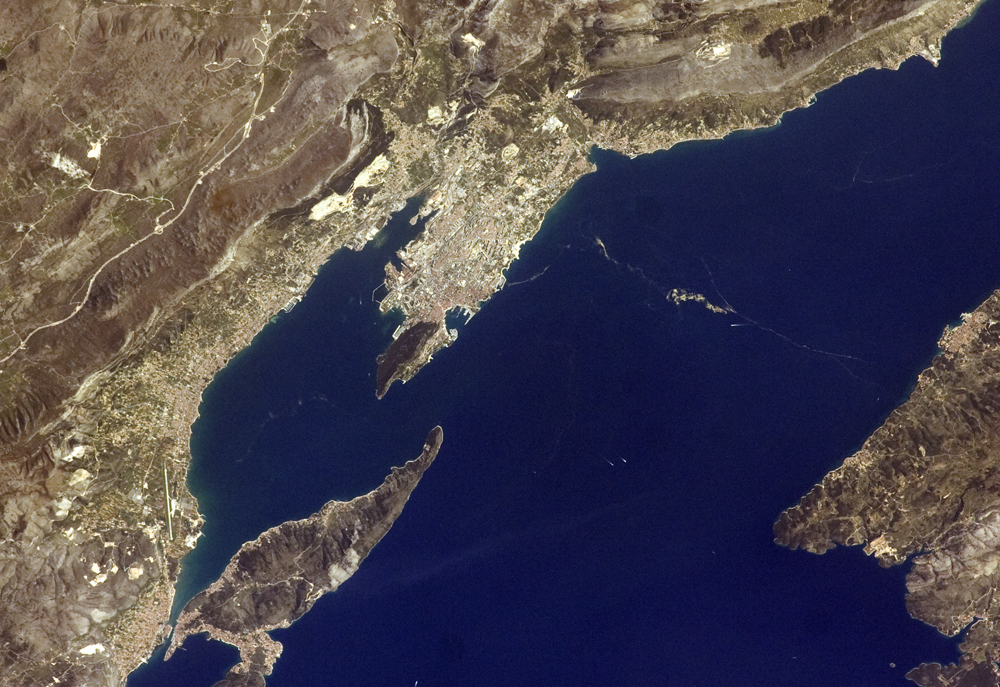
Image Caption: Dalmatian Coastline near Split, Croatia
One the world's most rugged coastlines is located in Croatia along the Adriatic Sea. This astronaut photograph features the Dalmatian coastline of Croatia around the city of Split. Much of the region's topography is characterized by northwest-southeast-oriented islands and embayments of the Adriatic Sea. These distinctive coastal land forms result from faulting (caused by tectonic activity in the region) and sea level rise since the end of the last ice age.
Split has a long history of human settlement. The Roman Emperor Diocletian retired to Spalatum (present-day Split) in 305, and his palace constitutes the core of the city today. The city is a popular resort destination for its historic sites, Mediterranean climate, and ready access to Adriatic Sea islands (such as Brae, to the south). Other large cities in the region include Kastela and Trogir; together with Split, these form an almost continuous urban corridor along the coast (visible as pink regions in the image).
A thin zone of disturbed water (tan patches) marking a water boundary appears in the Adriatic Sea between Split and the island of Brae. It may be a plankton bloom or a line of convergence between water masses, which creates rougher water. A unique combination of features--including dramatic topography that channels local winds, the complicated coastline, input of fresh water from rivers, and ample nutrients and natural surface oils--produce interesting mesoscale surface dynamics throughout the Adriatic Sea. Over the years, astronauts have taken images of the Split region using sunglint (the mirror-like reflection of the Sun off water) and changes in water color to highlight features like eddies, water boundaries and mixing zones between fresh waters flowing into the saltier (denser) waters of the Adriatic, and wind-driven surface currents.
Split is an important transit center connecting islands in the Adriatic Sea to the Italian peninsula, and it is an important regional manufacturing center of goods such as solar cells, plastics, and paper products. The city was heavily industrialized during the post-World War II period as a member state of Yugoslavia. By the 1980s, the marine environment bordered by Split, Kastela, and Trogir (known as Kastela Bay) had become one of the most polluted areas of the Adriatic, both from sewage and industrial pollution. Concerted efforts by the Croatian government and international partners to improve waste handling and treatment infrastructure over the past 10 years seem to have been successful in improving water quality.
