ISS018-E-6540

| NASA Photo ID | ISS018-E-6540 |
| Focal Length | 800mm |
| Date taken | 2008.10.31 |
| Time taken | 07:56:30 GMT |
Resolutions offered for this image:
1000 x 620 pixels 540 x 335 pixels 720 x 480 pixels 3072 x 2098 pixels 640 x 437 pixels
1000 x 620 pixels 540 x 335 pixels 720 x 480 pixels 3072 x 2098 pixels 640 x 437 pixels

Cloud masks available for this image:
Spacecraft nadir point: 30.5° N, 31.6° E
Photo center point: 29.9° N, 31.2° E
Photo center point by machine learning:
Photo center point: 29.9° N, 31.2° E
Photo center point by machine learning:
Nadir to Photo Center: Southwest
Spacecraft Altitude: 189 nautical miles (350km)
Camera: | Nikon D2Xs Electronic Still Camera |
Focal Length: | 800mm |
Camera Tilt: | 13 degrees |
Format: | 4288E: 4288 x 2848 pixel CMOS sensor, RGBG imager color filter |
Film Exposure: | |
| Additional Information | |
| Width | Height | Annotated | Cropped | Purpose | Links |
|---|---|---|---|---|---|
| 1000 pixels | 620 pixels | No | Yes | Earth From Space collection | Download Image |
| 540 pixels | 335 pixels | Yes | Yes | Earth From Space collection | Download Image |
| 720 pixels | 480 pixels | Yes | Yes | NASA's Earth Observatory web site | Download Image |
| 3072 pixels | 2098 pixels | No | No | Download Image | |
| 640 pixels | 437 pixels | No | No | Download Image |
Download Packaged File
Download a Google Earth KML for this Image
View photo footprint information
Download a GeoTIFF for this photo
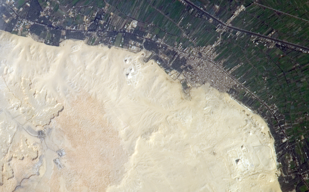
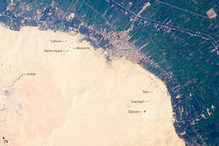
Image Caption: Cities of the Dead, Nile River Delta, Egypt
The ancient pharaohs (kings) and queens of Egypt established several royal cemeteries, along the Nile River valley. On the western riverbank, these necropoli (cities of the dead) were built on a gravelly desert plateau formed of limestone and clay overlooking the river. Several scarps (cliffs) are visible at image lower left. The most widely recognized features of royal Egyptian necropoli are pyramids, which frequently served as both tombs and monuments for their occupants. This detailed astronaut photograph illustrates a portion of the Nile Delta that includes two royal cemetery complexes, Abusir and Saqqara-North.
The present day village of Abusir is clearly visible as a grey-white irregular patch of urban surfaces that contrasts with green agricultural fields of the Nile Delta and tan desert sands and gravels to the west. The historic necropolis of Abusir is located to the northwest of the village at image top center. Three pyramids are readily visible in the image, all built by kings of the Fifth Dynasty (2,465-2,323 BC): Sahure, Niuserre, and Neferirkare. The site of Abusir was likely chosen due to the existence of a lake-now dry-that facilitated transport of building materials for the pyramids and other structures.
The northern portion of the large necropolis of Saqqara is also visible to the south-southwest (image right) of the village of Abusir. The largest pyramid in this complex is that of Djoser, a king of the Third Dynasty (2,650-2,575 BC). Other readily visible pyramids include that of Userkaf (Fifth Dynasty) and Teti (Sixth Dynasty: 2,323-2,150 BC), attesting to the long history of use of the Saqqara necropolis. Astronauts have also taken detailed imagery of other necropolis sites along the Nile River delta such as Giza and Dashur.
