ISS018-E-5660
| NASA Photo ID | ISS018-E-5660 |
| Focal Length | 180mm |
| Date taken | 2008.10.28 |
| Time taken | 17:20:40 GMT |
Resolutions offered for this image:
1000 x 660 pixels 540 x 356 pixels 720 x 480 pixels 3072 x 2098 pixels 640 x 437 pixels
1000 x 660 pixels 540 x 356 pixels 720 x 480 pixels 3072 x 2098 pixels 640 x 437 pixels
Cloud masks available for this image:
Spacecraft nadir point: 39.0° N, 105.4° W
Photo center point: 40.0° N, 105.7° W
Photo center point by machine learning:
Photo center point: 40.0° N, 105.7° W
Photo center point by machine learning:
Nadir to Photo Center: North
Spacecraft Altitude: 188 nautical miles (348km)
Country or Geographic Name: | USA-COLORADO |
Features: | LAKE GRANBY, TABERNASH, NIWOT RIDGE, ROCKY MOUNTAINS |
| Features Found Using Machine Learning: | |
Cloud Cover Percentage: | 10 (1-10)% |
Sun Elevation Angle: | 34° |
Sun Azimuth: | 155° |
Camera: | Nikon D2Xs Electronic Still Camera |
Focal Length: | 180mm |
Camera Tilt: | 18 degrees |
Format: | 4288E: 4288 x 2848 pixel CMOS sensor, RGBG imager color filter |
Film Exposure: | |
| Additional Information | |
| Width | Height | Annotated | Cropped | Purpose | Links |
|---|---|---|---|---|---|
| 1000 pixels | 660 pixels | No | Yes | Earth From Space collection | Download Image |
| 540 pixels | 356 pixels | Yes | Yes | Earth From Space collection | Download Image |
| 720 pixels | 480 pixels | Yes | Yes | NASA's Earth Observatory web site | Download Image |
| 3072 pixels | 2098 pixels | No | No | Download Image | |
| 640 pixels | 437 pixels | No | No | Download Image |
Download Packaged File
Download a Google Earth KML for this Image
View photo footprint information
Download a GeoTIFF for this photo
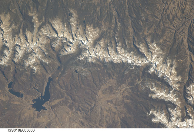
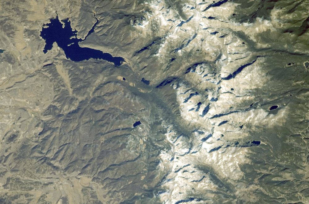
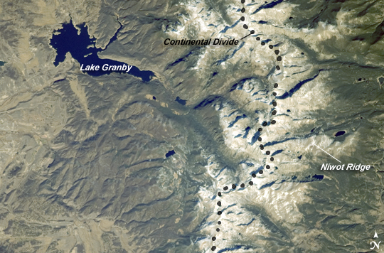
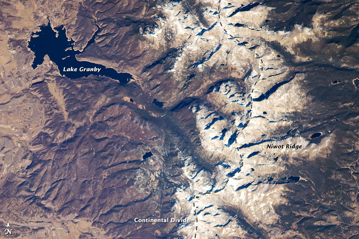
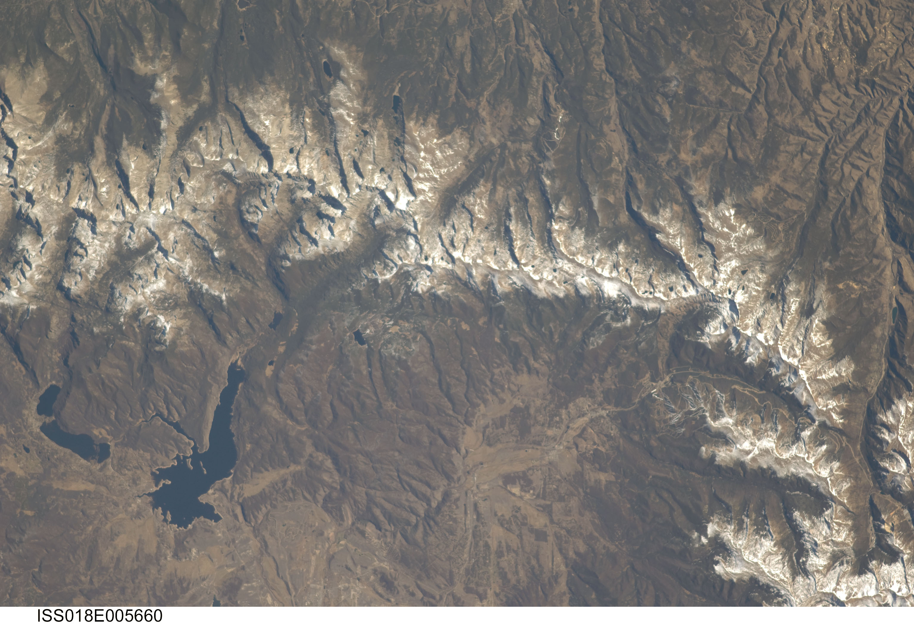
Image Caption: Great Divide, Rocky Mountains, Colorado
This astronaut photograph highlights a portion of the Great Divide in the Rocky Mountains approximately 31 kilometers due west of Boulder, Colorado. The Great Divide is one of four continental divides recognized by geographers and hydrologists in North America--the others being the Northern, Eastern, and Saint Lawrence Seaway Divides--but it is still generally (and erroneously) known as the Continental Divide. The Great Divide is a hydrologic boundary defined by the ultimate destination of precipitation; rainfall on the western side of the Divide flows to the Pacific Ocean, while rainfall on the eastern side flows to the Gulf of Mexico. It is easy to visualize such a boundary traced along the high ridges of the Rocky Mountains (dashed line), but in regions of less obvious topography, more detailed study of the local geomorphology and hydrology are required to map the location of the Divide.
This portion of the Rocky Mountains also hosts the Niwot Ridge Long Term Ecological Research (LTER) Site. Part of the National Science Foundation's LTER program, the Niwot Ridge site is used for studies of climate interactions with tundra and alpine ecosystems. Niwot Ridge is visible in this image as a large eastward spur off the central spine of the mountains (center right). The entire Niwot LTER site is located at elevations higher than 3000 meters, and it includes an active cirque glacier and glacial landforms, tarns (glacial lakes), and permafrost.
Lake Granby, located to the west of the Great Divide, is a reservoir on the Colorado River. It is the second-largest manmade body of water in the state of Colorado. Storage of water began in 1949. Today, the lake is popular location for fishing, boating, and camping.
