ISS018-E-35716
| NASA Photo ID | ISS018-E-35716 |
| Focal Length | 180mm |
| Date taken | 2009.02.24 |
| Time taken | 20:12:45 GMT |
Resolutions offered for this image:
1000 x 716 pixels 540 x 387 pixels 720 x 720 pixels 3072 x 2098 pixels 640 x 437 pixels
1000 x 716 pixels 540 x 387 pixels 720 x 720 pixels 3072 x 2098 pixels 640 x 437 pixels

Cloud masks available for this image:
Spacecraft nadir point: 42.4° S, 69.8° W
Photo center point: 42.9° S, 72.5° W
Photo center point by machine learning:
Photo center point: 42.9° S, 72.5° W
Photo center point by machine learning:
Nadir to Photo Center: West
Spacecraft Altitude: 198 nautical miles (367km)
Country or Geographic Name: | CHILE |
Features: | MINCHINMAVIDA VOLCANO, CHAITEN VOLCANO |
| Features Found Using Machine Learning: | |
Cloud Cover Percentage: | 10 (1-10)% |
Sun Elevation Angle: | 35° |
Sun Azimuth: | 292° |
Camera: | Nikon D2Xs Electronic Still Camera |
Focal Length: | 180mm |
Camera Tilt: | 40 degrees |
Format: | 4288E: 4288 x 2848 pixel CMOS sensor, RGBG imager color filter |
Film Exposure: | |
| Additional Information | |
| Width | Height | Annotated | Cropped | Purpose | Links |
|---|---|---|---|---|---|
| 1000 pixels | 716 pixels | No | Yes | Earth From Space collection | Download Image |
| 540 pixels | 387 pixels | Yes | Yes | Earth From Space collection | Download Image |
| 720 pixels | 720 pixels | Yes | Yes | NASA's Earth Observatory web site | Download Image |
| 3072 pixels | 2098 pixels | No | No | Download Image | |
| 640 pixels | 437 pixels | No | No | Download Image |
Download Packaged File
Download a Google Earth KML for this Image
View photo footprint information
Download a GeoTIFF for this photo
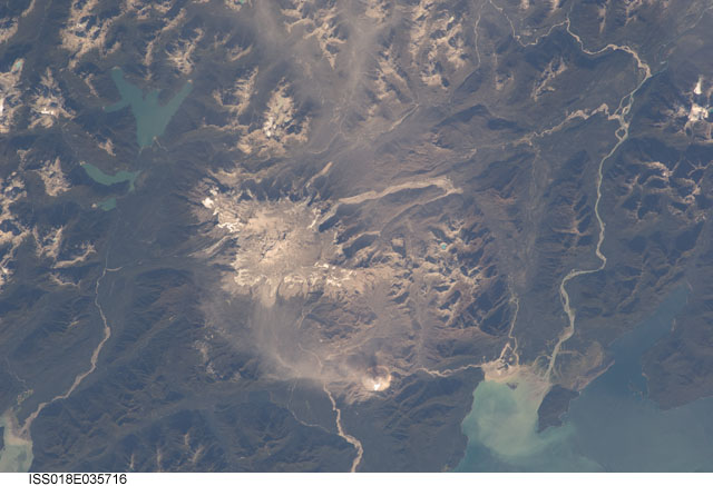
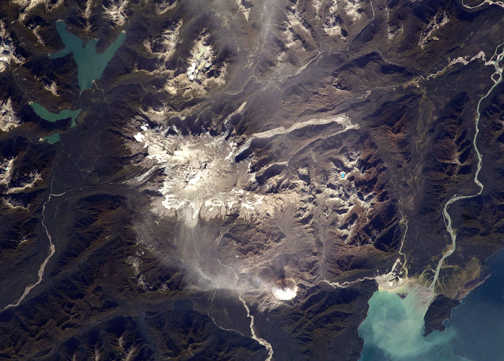
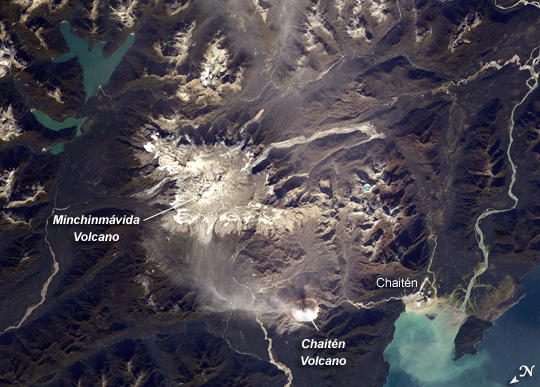
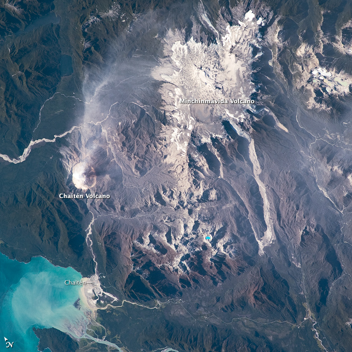
Image Caption: Minchinmavida and Chaiten Volcanoes, Chile
The Andes Mountains along the western coastline of South America include numerous active stratovolcanoes (steep-sided, cone-shaped volcanoes). The majority of these volcanoes were formed and are still fed by magma generated as the Nazca tectonic plate under the southeastern Pacific Ocean moves northeastward and plunges beneath the South American continental plate--a process known as subduction. The line of Andean volcanoes marks the approximate location of the subduction zone.
This astronaut photograph highlights two volcanoes located near the southern boundary of the Nazca-South America subduction zone in southern Chile. Dominating the scene is the massive Minchinmavida Volcano (image upper right). Charles Darwin observed an eruption of this glaciated volcano during his Galapagos Islands voyage in 1834; the last recorded eruption took place the following year. When this photo was taken, the white, snow-covered summit of Minchinmavida was blanketed by gray ash erupted from its much smaller but now-active neighbor to the west, Chaiten Volcano.
Chaiten Volcano is dominated by a large lava dome within a caldera (an emptied and collapsed magma chamber beneath a volcano). With no recorded history of eruptions, Chaiten roared back to life unexpectedly on May 2, 2008, generating dense ash plumes and forcing the evacuation of the nearby town of Chaiten. Volcanic activity continued at Chaiten in early 2009; several days before this astronaut photograph was taken, a new lava dome partially collapsed and generated a pyroclastic flow (a scalding avalanche of gas, ash, and rock debris). A steam and ash plume extended northeast from the eruptive center of the volcano at the time of this image.
