ISS018-E-24351
| NASA Photo ID | ISS018-E-24351 |
| Focal Length | 180mm |
| Date taken | 2009.01.27 |
| Time taken | 20:50:28 GMT |
Resolutions offered for this image:
1000 x 726 pixels 540 x 392 pixels 720 x 480 pixels 3072 x 2098 pixels 640 x 437 pixels
1000 x 726 pixels 540 x 392 pixels 720 x 480 pixels 3072 x 2098 pixels 640 x 437 pixels


Cloud masks available for this image:
Spacecraft nadir point: 16.4° S, 148.0° W
Photo center point: 17.0° S, 149.5° W
Photo center point by machine learning:
Photo center point: 17.0° S, 149.5° W
Photo center point by machine learning:
Nadir to Photo Center: West
Spacecraft Altitude: 191 nautical miles (354km)
Country or Geographic Name: | SOCIETY ISLANDS |
Features: | TITIAROA ATOLL, REEFS |
| Features Found Using Machine Learning: | |
Cloud Cover Percentage: | 25 (11-25)% |
Sun Elevation Angle: | 72° |
Sun Azimuth: | 99° |
Camera: | Nikon D2Xs Electronic Still Camera |
Focal Length: | 180mm |
Camera Tilt: | 27 degrees |
Format: | 4288E: 4288 x 2848 pixel CMOS sensor, RGBG imager color filter |
Film Exposure: | |
| Additional Information | |
| Width | Height | Annotated | Cropped | Purpose | Links |
|---|---|---|---|---|---|
| 1000 pixels | 726 pixels | No | Yes | Earth From Space collection | Download Image |
| 540 pixels | 392 pixels | Yes | Yes | Earth From Space collection | Download Image |
| 720 pixels | 480 pixels | Yes | Yes | NASA's Earth Observatory web site | Download Image |
| 3072 pixels | 2098 pixels | No | No | Download Image | |
| 640 pixels | 437 pixels | No | No | Download Image |
Download Packaged File
Download a Google Earth KML for this Image
View photo footprint information
Download a GeoTIFF for this photo
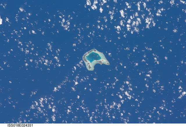
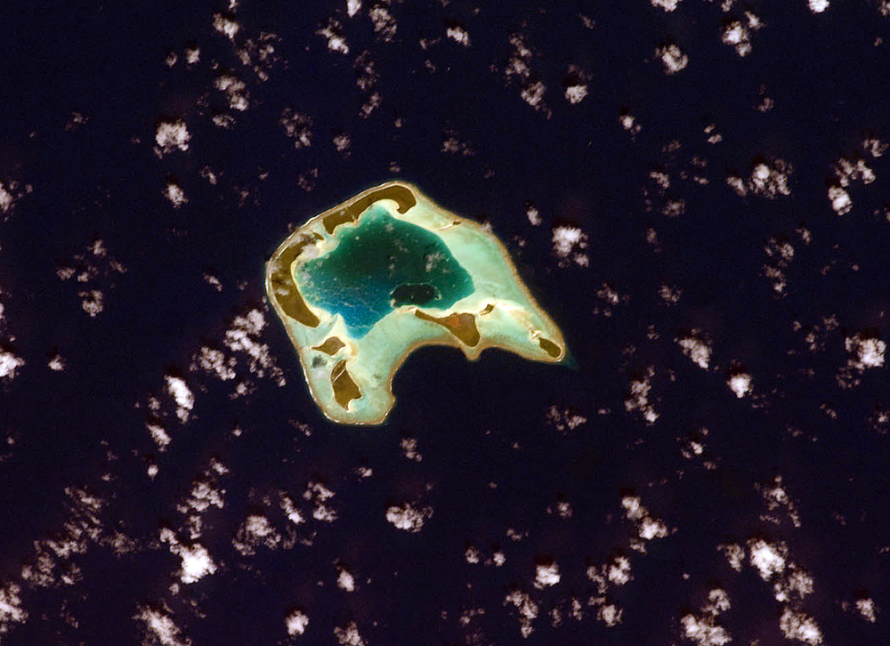
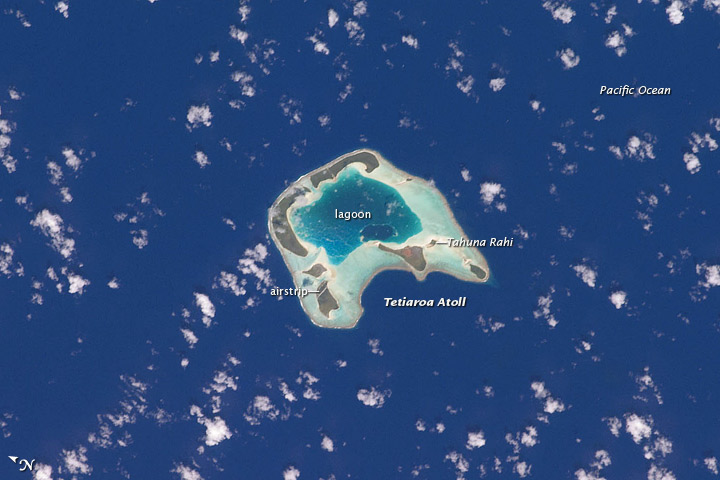
Image Caption: Tetiaroa Island, French Polynesia
Tetiaroa Island is part of the Society Islands archipelago in the southern Pacific Ocean, one of several island clusters in French Polynesia. Tetiaroa is an atoll comprised of thirteen small islets (or motus). This astronaut photograph illustrates the typical circular appearance of a fully developed atoll.
The ring of islands--covered in green vegetation and white-to-tan sandy beaches--develops on coral reefs, which originally form around a volcanic island. As the volcanic island gradually disappears due to subsidence and erosion, the coral reefs continue to grow upwards. Over time, the central volcanic island is completely submerged, leaving a ring of coral reefs and islands that surround a lagoon. The shallow lagoon waters appear blue-green in this image, and contrast with darker and deeper Pacific Ocean waters surrounding the atoll.
One of the motus in the southern portion of the atoll, Tahuna Rahi, is a protected bird sanctuary, and it is the nesting site of red- and brown-footed boobies, frigatebirds, and terns (among other species). Access to the atoll is via boat, as the airstrip was closed in 2004 due to safety and security concerns.
Tetiaroa Island is also known as "Marlon Brando's Island." The late film star purchased the atoll from the French Polynesian government between 1966 and 1967. While the motus were his property, the government retained the rights to the coral reefs and lagoons to preserve control of marine resources. Following Brando's death in 2004, ownership of the approximately 8-kilometer-wide atoll passed into other private hands, and there are now plans to build a luxury resort among the islets.
