ISS017-E-8290
| NASA Photo ID | ISS017-E-8290 |
| Focal Length | 800mm |
| Date taken | 2008.05.31 |
| Time taken | 13:17:37 GMT |
Resolutions offered for this image:
1000 x 661 pixels 540 x 357 pixels 540 x 334 pixels 2098 x 3072 pixels 437 x 639 pixels
1000 x 661 pixels 540 x 357 pixels 540 x 334 pixels 2098 x 3072 pixels 437 x 639 pixels


Cloud masks available for this image:
Spacecraft nadir point: 21.6° N, 31.5° E
Photo center point: 23.3° N, 30.6° E
Photo center point by machine learning:
Photo center point: 23.3° N, 30.6° E
Photo center point by machine learning:
Nadir to Photo Center: Northwest
Spacecraft Altitude: 183 nautical miles (339km)
Country or Geographic Name: | EGYPT |
Features: | TOSHKA LAKES, SAND DUNES |
| Features Found Using Machine Learning: | |
Cloud Cover Percentage: | 10 (1-10)% |
Sun Elevation Angle: | 42° |
Sun Azimuth: | 281° |
Camera: | Nikon D2Xs Electronic Still Camera |
Focal Length: | 800mm |
Camera Tilt: | 32 degrees |
Format: | 4288E: 4288 x 2848 pixel CMOS sensor, RGBG imager color filter |
Film Exposure: | |
| Additional Information | |
| Width | Height | Annotated | Cropped | Purpose | Links |
|---|---|---|---|---|---|
| 1000 pixels | 661 pixels | No | Yes | Earth From Space collection | Download Image |
| 540 pixels | 357 pixels | Yes | Yes | Earth From Space collection | Download Image |
| 540 pixels | 334 pixels | Yes | Yes | NASA's Earth Observatory web site | Download Image |
| 2098 pixels | 3072 pixels | No | No | Download Image | |
| 437 pixels | 639 pixels | No | No | Download Image |
Download Packaged File
Download a Google Earth KML for this Image
View photo footprint information
Download a GeoTIFF for this photo
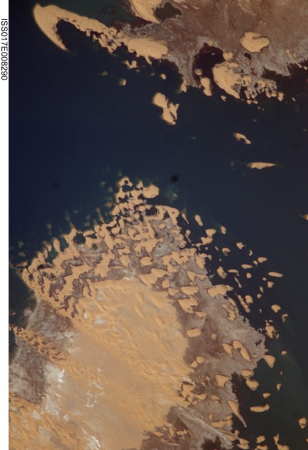
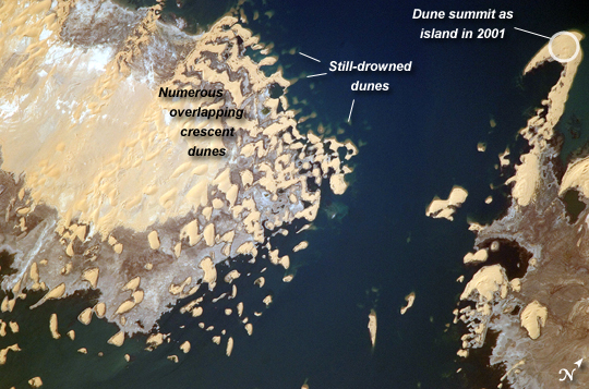
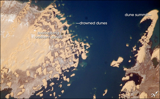
Image Caption: Toshka Lakes, Southern Egypt
In the late 1990s, Egypt's new manmade Toshka Lakes, fed from Lake Nasser via a canal, grew and spilled into new basins to become four major and two smaller lakes. These lakes extended 120 kilometers across the desert west of the Nile River in southern Egypt. Starting in 2002, astronauts have seen the lakes slowly decline, with the telltale ring of darker, moistened ground showing the previous higher water levels (see prior comparison of astronaut imagery of the lakes). The rise and fall of Toshka Lakes and the economic development surrounding the region are dependent on climate fluctuations and water agreements with upstream countries that, in turn, determine the long-term water flow in the lower Nile.
This astronaut photograph, covering a distance of 11.3 kilometers from left to right, shows shoreline detail of the third large lake. Lake water appears deep blue to blue-green, and parallel with the shoreline is a wide brown zone which was under water until 2002. Most of the bright yellow sand dunes in the view are re-emerging as the lake level drops; most are outlined by thin wet margins. Still-submerged dunes can be seen offshore as blurred tan smudges (image top center). The summit of the biggest horn-shaped dune (image top right) was an island more than five kilometers offshore in images from 2001. The patterns of the overlapping crescent dunes gives a strong sense of dune migration southwards; the horns of the crescent dunes point in the direction of dune movement, from top right towards lower left. Dominant northerly winds drive the dunes southward, except, of course, when they are under water.
