ISS017-E-13769
| NASA Photo ID | ISS017-E-13769 |
| Focal Length | 400mm |
| Date taken | 2008.08.19 |
| Time taken | 14:33:46 GMT |
Resolutions offered for this image:
1000 x 668 pixels 540 x 361 pixels 540 x 405 pixels 3072 x 2098 pixels 640 x 437 pixels
1000 x 668 pixels 540 x 361 pixels 540 x 405 pixels 3072 x 2098 pixels 640 x 437 pixels

Cloud masks available for this image:
Spacecraft nadir point: 35.8° N, 9.4° E
Photo center point: 36.9° N, 10.2° E
Photo center point by machine learning:
Photo center point: 36.9° N, 10.2° E
Photo center point by machine learning:
Nadir to Photo Center: Northeast
Spacecraft Altitude: 190 nautical miles (352km)
Country or Geographic Name: | TUNISIA |
Features: | TUNIS METRO AREA, LAKE OF TUNIS |
| Features Found Using Machine Learning: | |
Cloud Cover Percentage: | 10 (1-10)% |
Sun Elevation Angle: | 42° |
Sun Azimuth: | 253° |
Camera: | Nikon D2Xs Electronic Still Camera |
Focal Length: | 400mm |
Camera Tilt: | 23 degrees |
Format: | 4288E: 4288 x 2848 pixel CMOS sensor, RGBG imager color filter |
Film Exposure: | |
| Additional Information | |
| Width | Height | Annotated | Cropped | Purpose | Links |
|---|---|---|---|---|---|
| 1000 pixels | 668 pixels | No | Yes | Earth From Space collection | Download Image |
| 540 pixels | 361 pixels | Yes | Yes | Earth From Space collection | Download Image |
| 540 pixels | 405 pixels | Yes | Yes | NASA's Earth Observatory web site | Download Image |
| 3072 pixels | 2098 pixels | No | No | Download Image | |
| 640 pixels | 437 pixels | No | No | Download Image |
Download Packaged File
Download a Google Earth KML for this Image
View photo footprint information
Download a GeoTIFF for this photo
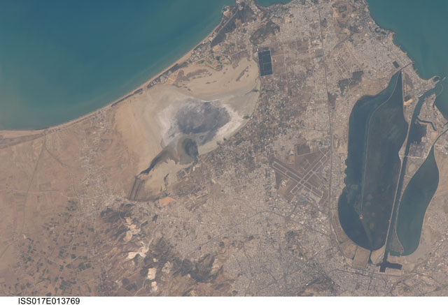
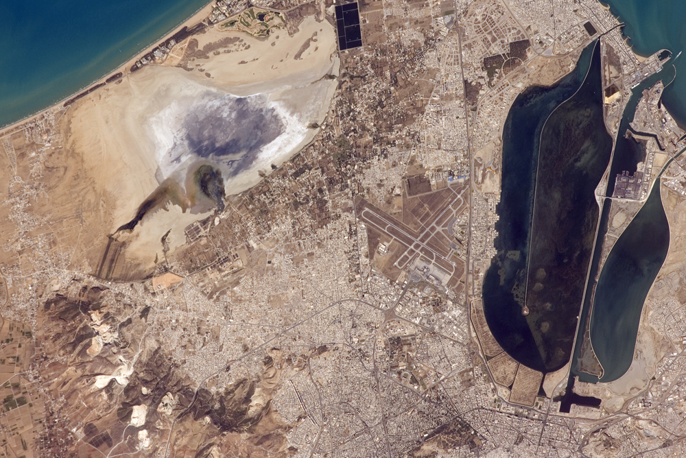
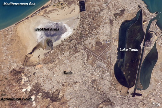
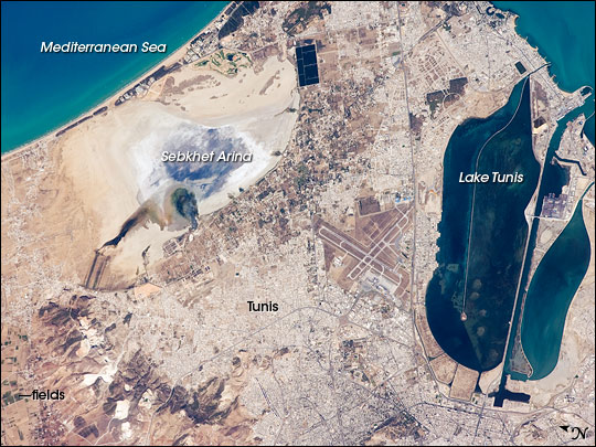
Image Caption: Tunis, Tunisia
The city of Tunis, capital of Tunisia, is located along the Mediterranean coast of northern Africa. Sharing much of its history with famous Carthage to the north, Tunis was also destroyed by the Roman Empire in approximately 146 BC. Tunis, however, was rebuilt by the Romans and became an important agricultural center. Modern Tunis serves as the administrative center for the whole of Tunisia, and as a commercial hub in the northern part of the country.
The urban area of Tunis is located on a flat coastal plain, and is distinguished in this astronaut photograph from the surrounding desert by the pattern of grey and tan buildings and the dark street grid. The city is bordered by an evaporating saline lake to the northeast known as Sebkhet Arina (upper left). Evaporite minerals such as halite (sodium chloride, or table salt) and gypsum produce the white deposits. They surround the darker lake center, where there is more moisture. The western urban-rural fringe is defined by a range of low hills (lower left). On the western side of these hills, dark green agricultural fields are visible.
To the southeast of the city is Lake Tunis, a lagoon that people have significantly altered from its natural state. For example, it is completely closed off from the Mediterranean Sea except for two channels, and has been since Roman times. The general lack of water circulation and input of nutrients from wastewater have altered the ecosystem, allowing reef-forming marine worms to become established; the reefs further stifle water circulation. The wastewater also causes eutrophication (overly fertile waters that trigger algae overgrowth) and occasional fish kills.
