ISS017-E-10708
| NASA Photo ID | ISS017-E-10708 |
| Focal Length | 12mm |
| Date taken | 2008.07.09 |
| Time taken | 12:18:54 GMT |

Cloud masks available for this image:
Spacecraft nadir point: 27.4° N, 55.0° W
Photo center point: 24.0° N, 57.5° W
Photo center point by machine learning:
Photo center point: 24.0° N, 57.5° W
Photo center point by machine learning:
Nadir to Photo Center: Southwest
Spacecraft Altitude: 187 nautical miles (346km)
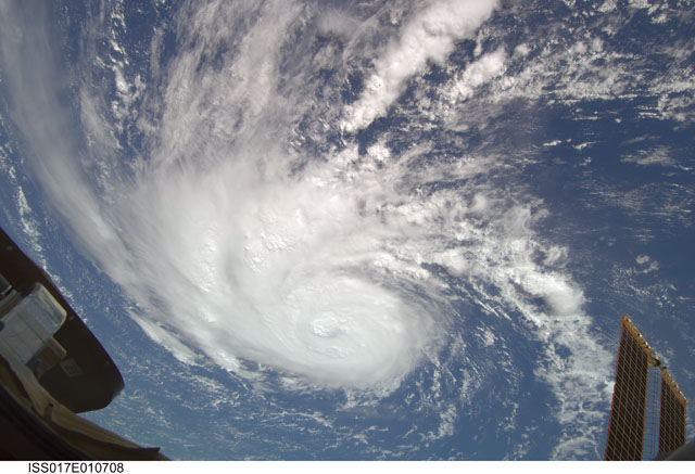
Country or Geographic Name: | ATLANTIC OCEAN |
Features: | HURRICANE BERTHA, ISS |
| Features Found Using Machine Learning: | |
Cloud Cover Percentage: | 100 (76-100)% |
Sun Elevation Angle: | 43° |
Sun Azimuth: | 84° |
Camera: | Nikon D2Xs Electronic Still Camera |
Focal Length: | 12mm |
Camera Tilt: | 54 degrees |
Format: | 4288E: 4288 x 2848 pixel CMOS sensor, RGBG imager color filter |
Film Exposure: | |
| Additional Information | |
| Width | Height | Annotated | Cropped | Purpose | Links |
|---|---|---|---|---|---|
| 3072 pixels | 2098 pixels | No | No | Download Image | |
| 640 pixels | 437 pixels | No | No | Download Image |
Download Packaged File
Download a Google Earth KML for this Image
View photo footprint information
Download a GeoTIFF for this photo
Image Caption: ISS017-E-010708 (9 July 2008) --- Hurricane Bertha was traveling northward at 10 knots (11.5 miles per hour) across the eastern part of the central Atlantic Ocean when this image was taken on July 9 by one of the Expedition 17 crewmembers aboard the International Space Station from a vantage point of 220 statute miles above the Earth. The sustained winds were 85 knots (97.9 miles per hour) with gusts up to 105 knots (121.0 miles per hour) and predicted to intensify. Mature and developing Cumulonimbus-type clouds are seen scattered through the cloud bands of the hurricane's system.
