ISS015-E-8920

| NASA Photo ID | ISS015-E-8920 |
| Focal Length | 400mm |
| Date taken | 2007.05.19 |
| Time taken | 16:54:53 GMT |
Resolutions offered for this image:
1000 x 659 pixels 540 x 356 pixels 540 x 405 pixels 3032 x 2064 pixels 639 x 435 pixels
1000 x 659 pixels 540 x 356 pixels 540 x 405 pixels 3032 x 2064 pixels 639 x 435 pixels
Cloud masks available for this image:
Spacecraft nadir point: 22.1° N, 78.3° W
Photo center point: 25.2° N, 80.5° W
Photo center point by machine learning:
Photo center point: 25.2° N, 80.5° W
Photo center point by machine learning:
Nadir to Photo Center: Northwest
Spacecraft Altitude: 178 nautical miles (330km)
Country or Geographic Name: | USA-FLORIDA |
Features: | FLORIDA B., CAN., MARSH, ROADS |
| Features Found Using Machine Learning: | |
Cloud Cover Percentage: | 10 (1-10)% |
Sun Elevation Angle: | 86° |
Sun Azimuth: | 122° |
Camera: | Kodak DCS760c Electronic Still Camera |
Focal Length: | 400mm |
Camera Tilt: | 52 degrees |
Format: | 3060E: 3060 x 2036 pixel CCD, RGBG array |
Film Exposure: | |
| Additional Information | |
| Width | Height | Annotated | Cropped | Purpose | Links |
|---|---|---|---|---|---|
| 1000 pixels | 659 pixels | No | Yes | Earth From Space collection | Download Image |
| 540 pixels | 356 pixels | Yes | Yes | Earth From Space collection | Download Image |
| 540 pixels | 405 pixels | Yes | Yes | NASA's Earth Observatory web site | Download Image |
| 3032 pixels | 2064 pixels | No | No | Download Image | |
| 639 pixels | 435 pixels | No | No | Download Image |
Download Packaged File
Download a Google Earth KML for this Image
View photo footprint information
Download a GeoTIFF for this photo
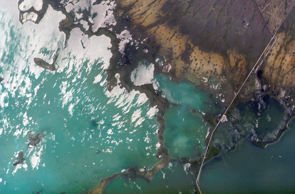
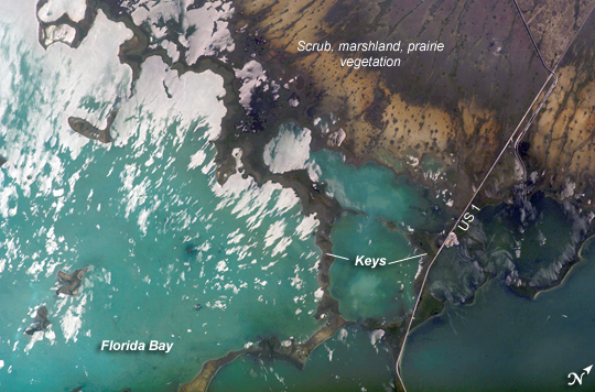
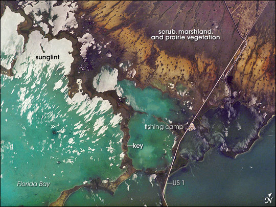
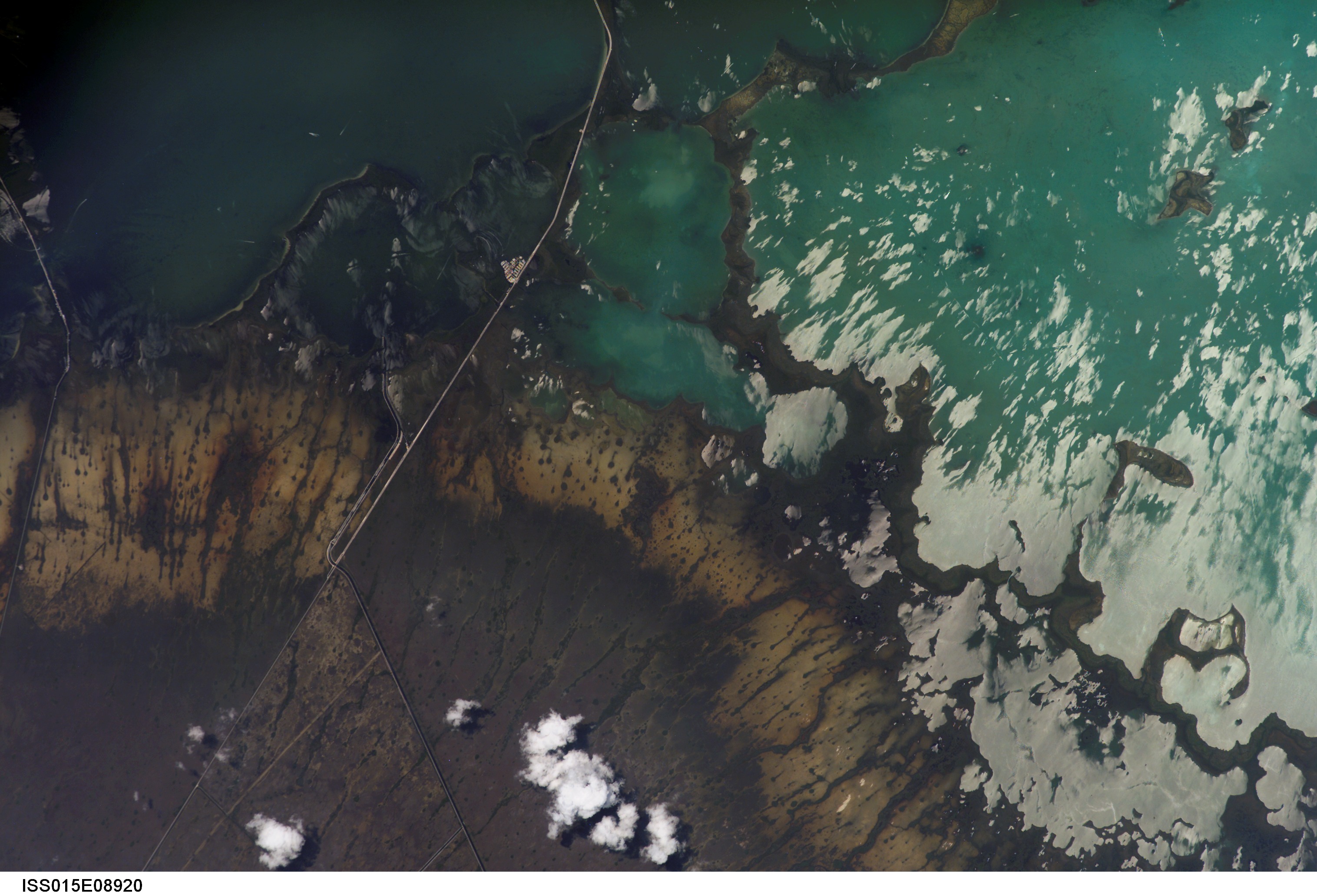
Image Caption: Southern Everglades National Park, Florida:
Everglades National Park in southern Florida is the largest subtropical wilderness in the United States. Known as the "river of grass," the Everglades wetlands and wooded uplands host a variety of endangered species including crocodiles, manatees, and panthers. During the late nineteenth and twentieth centuries, the original 11,000 square miles of wetlands were viewed as useless swampland in need of reclamation. The success of reclamation efforts--for agriculture and urban expansion in southern Florida--has led to the loss of approximately 50 percent of the original wetlands and 90 percent of wading bird species. Today, an extensive restoration effort is underway to return portions of the Everglades to a more natural state and prevent further ecosystem degradation.
This astronaut photograph highlights the southern Everglades, where the wetlands meet Florida Bay. Thin fingers of land and small islands (keys) host mangrove, hardwood hammocks (tree-covered mounds), marsh and prairie (mainly dark to light green in the image). The tan and grayish-brown areas at image upper right are dominantly scrub, marshland and prairie; small green "dots" and narrow lines in this region are isolated mangrove and hardwood stands indicating the general direction of slow water flow toward the bay. The silver-gray regions at image left are water surfaces highlighted by sunglint, light reflected off the water surface directly back towards the astronaut aboard the International Space Station. The roadway forming the western boundary of the National Park is U.S. Route 1, which connects the Miami metropolitan area to the north (not shown) with the Florida Keys to the south (not shown). A small tan patch visible along the roadway is a fishing camp.
