ISS015-E-29867
| NASA Photo ID | ISS015-E-29867 |
| Focal Length | 800mm |
| Date taken | 2007.09.20 |
| Time taken | 14:46:43 GMT |
Resolutions offered for this image:
1000 x 680 pixels 540 x 367 pixels 540 x 334 pixels 3032 x 2064 pixels 639 x 435 pixels
1000 x 680 pixels 540 x 367 pixels 540 x 334 pixels 3032 x 2064 pixels 639 x 435 pixels


Cloud masks available for this image:
Spacecraft nadir point: 39.7° N, 110.1° W
Photo center point: 40.5° N, 112.2° W
Photo center point by machine learning:
Photo center point: 40.5° N, 112.2° W
Photo center point by machine learning:
Nadir to Photo Center: West
Spacecraft Altitude: 181 nautical miles (335km)
Country or Geographic Name: | USA-UTAH |
Features: | OPEN PIT MINE, BINGHAM CANYON |
| Features Found Using Machine Learning: | |
Cloud Cover Percentage: | 10 (1-10)% |
Sun Elevation Angle: | 18° |
Sun Azimuth: | 104° |
Camera: | Kodak DCS760c Electronic Still Camera |
Focal Length: | 800mm |
Camera Tilt: | 37 degrees |
Format: | 3060E: 3060 x 2036 pixel CCD, RGBG array |
Film Exposure: | |
| Additional Information | |
| Width | Height | Annotated | Cropped | Purpose | Links |
|---|---|---|---|---|---|
| 1000 pixels | 680 pixels | No | Yes | Earth From Space collection | Download Image |
| 540 pixels | 367 pixels | Yes | Yes | Earth From Space collection | Download Image |
| 540 pixels | 334 pixels | Yes | Yes | NASA's Earth Observatory web site | Download Image |
| 3032 pixels | 2064 pixels | No | No | Download Image | |
| 639 pixels | 435 pixels | No | No | Download Image |
Download Packaged File
Download a Google Earth KML for this Image
View photo footprint information
Download a GeoTIFF for this photo
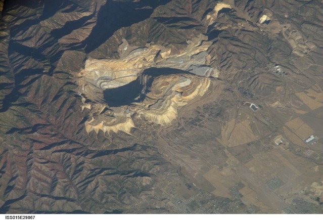
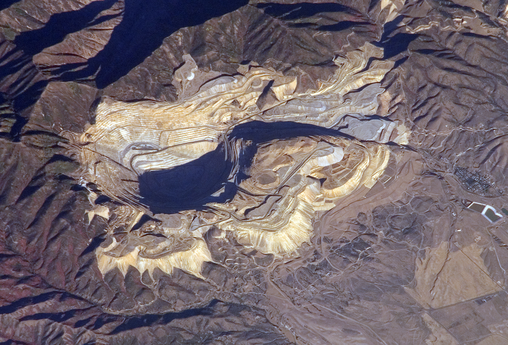
Image Caption: ISS015-E-29867 (20 Sept. 2007) --- Bingham Canyon Mine, Utah is featured in this image photographed by an Expedition 15 crewmember on the International Space Station. The Bingham Canyon Mine (center) located approximately 32 kilometers to the southwest of Salt Lake City, UT is one of the largest open-pit mines in the world, measuring over 4 kilometers wide and 1,200 meters deep. The mine exploits a porphyry copper deposit, a type of geological structure formed by crystal-rich magma moving upwards through pre-existing rock layers. As the magma cools and crystallizes (forming an igneous rock with large crystals in a fine-grained matrix, known as a porphyry), hot fluids circulate through the magma and surrounding rocks via fractures. This process of hydrothermal alteration typically forms copper-bearing and other minerals in spatial patterns that a geologist recognizes as a potential porphyry copper deposit. Parallel benches (stepped terraces), visible along the western pit face (center left), range from 16 to 25 meters high - these provide access for equipment to work the rock face, as well as maintaining stability of the sloping pit walls. A dark, larger roadway is also visible directly below the benches. Brown to gray, flat topped hills of gangue (waste rock) surround the pit, and are thrown into sharp relief by shadows and the oblique viewing angle of this image. Leachate reservoirs associated with ore processing are visible to the south of the city of Bingham Canyon, UT (right).
Bingham Canyon Mine, Utah:
The Bingham Canyon Mine (image center) is one of the largest open-pit mines in the world, measuring over 4 kilometers wide and 1,200 meters deep. Located about 30 kilometers southwest of Salt Lake City, Utah, the mine exploits a porphyry copper deposit, a geological structure formed by crystal-rich magma moving upwards through pre-existing rock layers. As the magma cools and crystallizes, it forms an igneous rock with large crystals embedded in a fine-grained matrix, known as a porphyry. Hot fluids circulate through the magma and surrounding rocks via fractures, depositing copper-bearing and other minerals in spatial patterns that a geologist recognizes as a potential porphyry copper deposit.
Mining first began in Bingham Canyon in the late nineteenth century, when shafts were sunk to remove gold, silver, and lead deposits that played out by the early 1900s. It would take the advent of open-pit mining in 1899 to turn the Bingham copper deposit into an economically favorable resource. In open-pit mining, the copper-containing rocks are excavated from the surface downward in terraces. By the 1930s, open-pit mining had turned "the Hill" at Bingham Canyon into "the Pit."
This astronaut photograph of the Bingham Canyon Mine shows parallel benches (stepped terraces) along the western pit face. These benches range from 16 to 25 meters high, and they provide access for equipment to work the rock face and maintaining the stability of the sloping pit walls. A dark, larger roadway is also visible directly below the benches. Brown to gray, flat-topped hills of gangue (waste rock) surround the pit, and are thrown into sharp relief by shadows and the oblique (from the side) viewing angle of the photograph. Reservoirs for leach water (associated with ore processing) are visible to the south of the city of Bingham Canyon.
Today's copper market is booming thanks to global demands from construction, telecommunications, and electronics sectors of the economy. The Kennecott Utah Copper Company removes about half a million tons of material from the Bingham Canyon Mine every day for processing. In 1906, the rate of removal was 100,000 tons of material per month. Over 17 million tons of copper have been removed to date. Geological and engineering models suggest that the mine can be deepened by an additional 200 meters before extraction costs become greater than the value of the remaining copper.
The geological and chemical processes that produce copper deposits also produce minerals such as iron sulfides, which react with water or oxygen on the surface to produce colorful minerals. Geologists can sometimes use satellite observations to identify places where the topography and the rock types on the surface suggest copper ores might be present below ground. Read the feature story Prospecting from Orbit for more information.
