ISS015-E-22274
| NASA Photo ID | ISS015-E-22274 |
| Focal Length | 95mm |
| Date taken | 2007.08.13 |
| Time taken | 01:33:38 GMT |
Resolutions offered for this image:
1000 x 660 pixels 540 x 357 pixels 540 x 538 pixels 3072 x 2096 pixels 639 x 436 pixels
1000 x 660 pixels 540 x 357 pixels 540 x 538 pixels 3072 x 2096 pixels 639 x 436 pixels

Cloud masks available for this image:
Spacecraft nadir point: 48.7° N, 110.6° W
Photo center point: 45.5° N, 110.5° W
Photo center point by machine learning:
Photo center point: 45.5° N, 110.5° W
Photo center point by machine learning:
Nadir to Photo Center: South
Spacecraft Altitude: 183 nautical miles (339km)
Country or Geographic Name: | USA-MONTANA |
Features: | ABSAROKA RANGE FOREST FIRES |
| Features Found Using Machine Learning: | |
Cloud Cover Percentage: | 100 (76-100)% |
Sun Elevation Angle: | 10° |
Sun Azimuth: | 281° |
Camera: | Nikon D1 Electronic Still Camera |
Focal Length: | 95mm |
Camera Tilt: | 46 degrees |
Format: | 2000E: 2000 x 1312 pixel CCD, RGBG imager color filter |
Film Exposure: | |
| Additional Information | |
| Width | Height | Annotated | Cropped | Purpose | Links |
|---|---|---|---|---|---|
| 1000 pixels | 660 pixels | No | Yes | Earth From Space collection | Download Image |
| 540 pixels | 357 pixels | Yes | Yes | Earth From Space collection | Download Image |
| 540 pixels | 538 pixels | Yes | Yes | NASA's Earth Observatory web site | Download Image |
| 3072 pixels | 2096 pixels | No | No | Download Image | |
| 639 pixels | 436 pixels | No | No | Download Image |
Download Packaged File
Download a Google Earth KML for this Image
View photo footprint information
Download a GeoTIFF for this photo
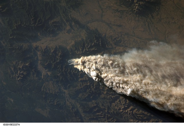
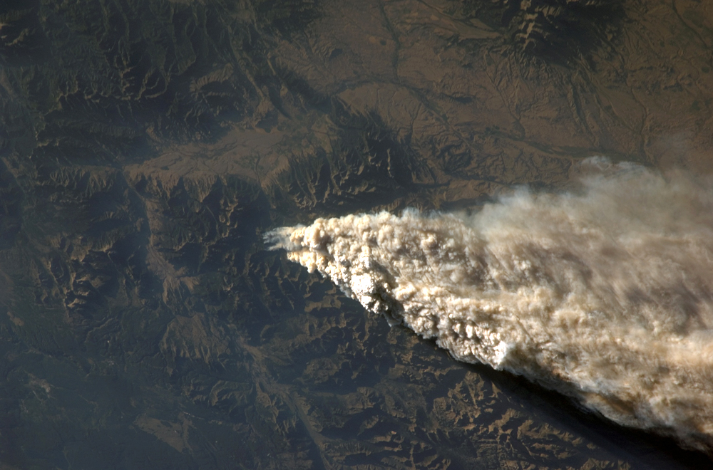
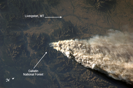
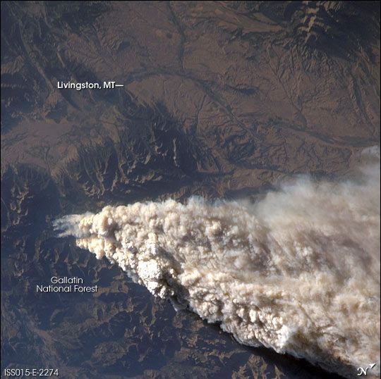
Image Caption: ISS015-E-22274 (13 Aug. 2007) --- Smoke plumes from a forest fire in the Gallatin National Forest, Montana is featured in this image photographed by an Expedition 15 crewmember on the International Space Station while Space Shuttle Endeavour (STS-118) was docked with the station.
Smoke Plumes over Idaho and Montana:
On August 13, 2007, while docked to the International Space Station (ISS), the crew members of Shuttle Mission STS-118 and ISS Expedition 15 reported seeing the smoke plumes from wide-spread fires across Idaho and Montana. The crew photographed and downlinked images of isolated plumes (this image) and regional views of the smoke (ISS015-E-22276) from different perspectives. Strong westerly winds were driving the smoke eastward.
The close-up view shows the WH Complex Fire in southern Montana, which was burning in Gallatin National Forest. As of Friday, August 17, the National Interagency Fire Center estimated its size as 25,400 acres, and it was only 5 percent contained. The rugged topography that makes firefighting in the area so difficult is highlighted by shadows created by the oblique (from the side) perspective from which the astronauts took the photo. The plume has topography of its own, some plumes towering above others, casting dark shadows.
The regional view was taken looking westward toward the horizon. It shows fires not only in Montana, but also fires to the south in Wyoming, and to the northwest in Idaho. South (to the left) of the WH Complex Fire are the Columbine 1 Fire in Yellowstone National Park (18,500 acres and 0 percent contained), and the Hardscrabble Fire in Bridger-Teton National Forest (3,074 acres and 40 percent contained).
An even broader regional view of the extent of the fires was captured by the Moderate Resolution Imaging Spectroradiometer (MODIS) sensor onboard NASA's Aqua satellite on August 12, 2007, the day before these images were taken by astronauts onboard the ISS.
