ISS015-E-18808
| NASA Photo ID | ISS015-E-18808 |
| Focal Length | 800mm |
| Date taken | 2007.07.21 |
| Time taken | 09:06:10 GMT |
Resolutions offered for this image:
1000 x 678 pixels 540 x 366 pixels 540 x 405 pixels 3032 x 2064 pixels 639 x 435 pixels
1000 x 678 pixels 540 x 366 pixels 540 x 405 pixels 3032 x 2064 pixels 639 x 435 pixels
Cloud masks available for this image:
Spacecraft nadir point: 37.4° N, 5.2° W
Photo center point: 35.9° N, 5.3° W
Photo center point by machine learning:
Photo center point: 35.9° N, 5.3° W
Photo center point by machine learning:
Nadir to Photo Center: South
Spacecraft Altitude: 174 nautical miles (322km)
Country or Geographic Name: | SPAIN |
Features: | CEUTA, MEDITERRANEAN SEA |
| Features Found Using Machine Learning: | |
Cloud Cover Percentage: | 10 (1-10)% |
Sun Elevation Angle: | 44° |
Sun Azimuth: | 97° |
Camera: | Kodak DCS760c Electronic Still Camera |
Focal Length: | 800mm |
Camera Tilt: | 27 degrees |
Format: | 3060E: 3060 x 2036 pixel CCD, RGBG array |
Film Exposure: | |
| Additional Information | |
| Width | Height | Annotated | Cropped | Purpose | Links |
|---|---|---|---|---|---|
| 1000 pixels | 678 pixels | No | Yes | Earth From Space collection | Download Image |
| 540 pixels | 366 pixels | Yes | Yes | Earth From Space collection | Download Image |
| 540 pixels | 405 pixels | Yes | Yes | NASA's Earth Observatory web site | Download Image |
| 3032 pixels | 2064 pixels | No | No | Download Image | |
| 639 pixels | 435 pixels | No | No | Download Image |
Download Packaged File
Download a Google Earth KML for this Image
View photo footprint information
Download a GeoTIFF for this photo
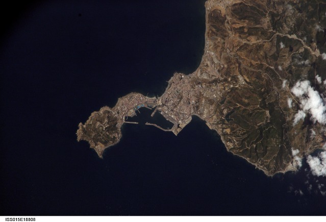
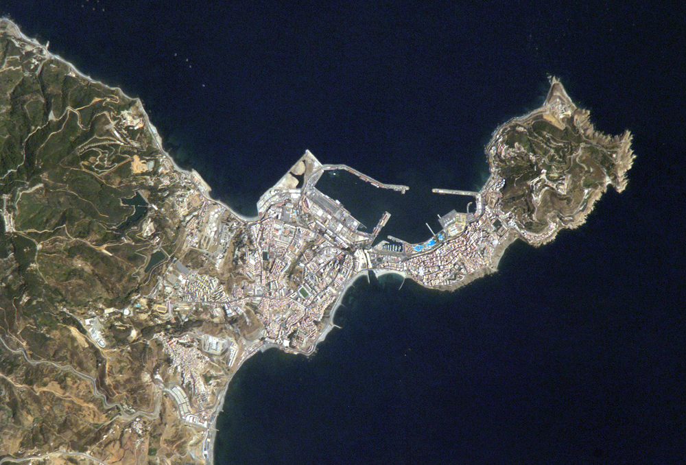
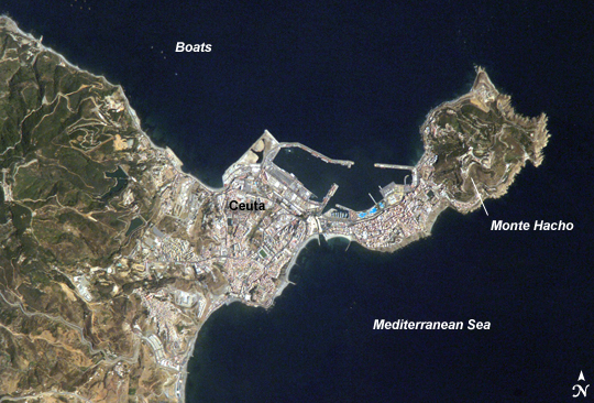
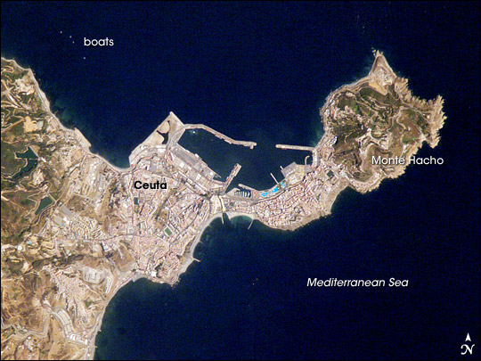
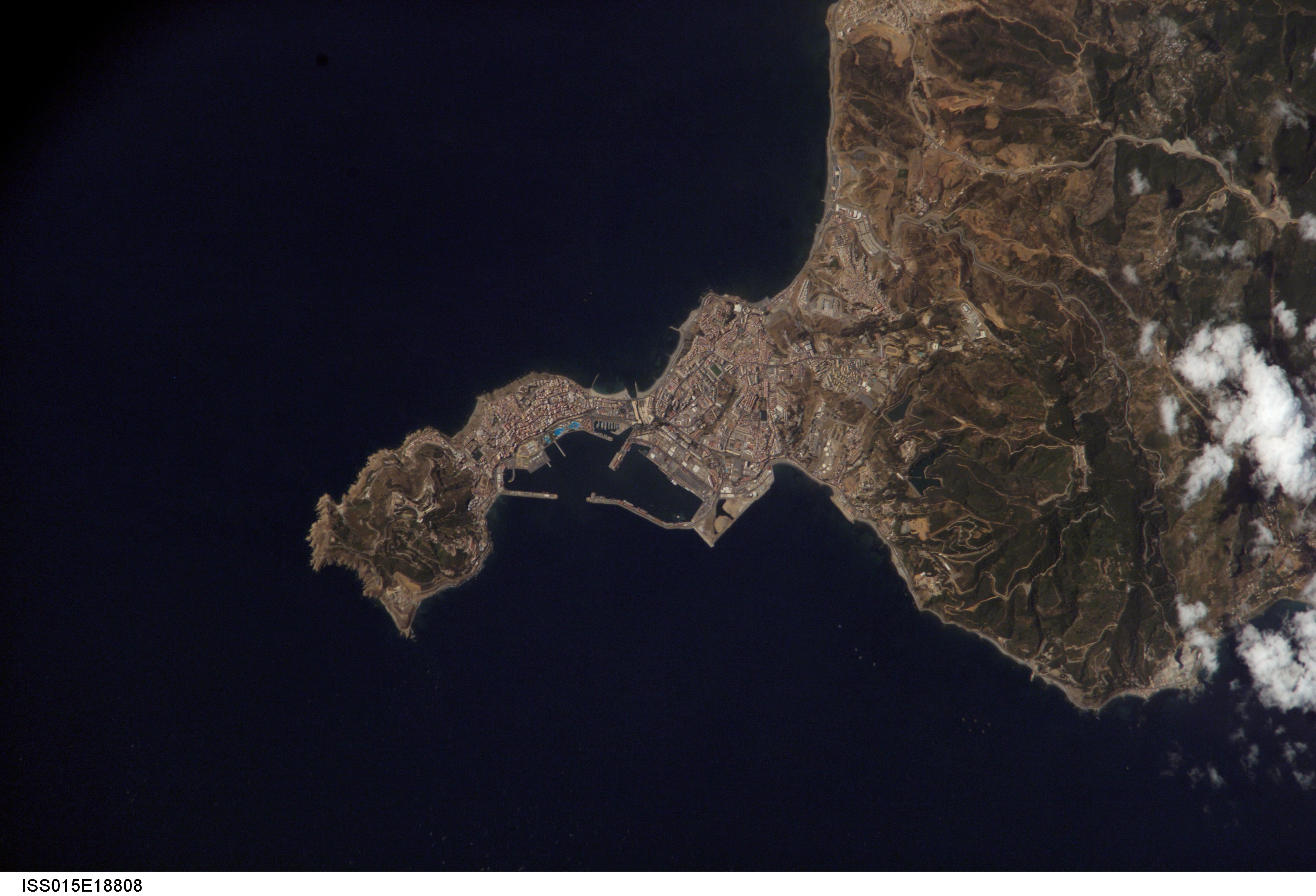
Image Caption: Ceuta, Northern Africa:
The southern tip of Spain and the northern tip of Africa come close to touching at the Strait of Gibraltar. At the Strait's narrowest point, only about 13 kilometers (8 miles) separate Spain from Morocco. The small Spanish enclave Ceuta occupies a narrow isthmus of land on the African side of the Strait of Gibraltar; the rest of the surrounding territory is Morocco. The isthmus and the city of Ceuta have been used as a military base since the Roman Empire occupied the area around AD 42; the city today supports a fort garrisoned by the Spanish army.
This astronaut photograph illustrates the sharp contrasts in land surfaces in the area. Densely populated Ceuta occupies the center of the image, its maze of pink and white residential and industrial rooftops occasionally broken by patches of green--city parks and athletic fields. North of the city, seawalls enclose a small bay and harbor. On the beach, bright blue patches are large water parks. Green, vegetated slopes surround the Spanish fort that sits at the top of Monte Hacho, at the eastern tip of the isthmus. (The fort commands a clear view of the Strait of Gibraltar, which is visible in a regional view of the area. Several small boats are visible near the coastline to the northwest and south of Ceuta.
