ISS015-E-10125
| NASA Photo ID | ISS015-E-10125 |
| Focal Length | 180mm |
| Date taken | 2007.05.30 |
| Time taken | 14:46:44 GMT |
Resolutions offered for this image:
1000 x 775 pixels 540 x 419 pixels 540 x 949 pixels 540 x 540 pixels 3032 x 2064 pixels 639 x 435 pixels
1000 x 775 pixels 540 x 419 pixels 540 x 949 pixels 540 x 540 pixels 3032 x 2064 pixels 639 x 435 pixels


Spacecraft nadir point: 50.5° S, 21.8° W
Photo center point: 48.8° S, 24.0° W
Photo center point by machine learning:
Photo center point: 48.8° S, 24.0° W
Photo center point by machine learning:
Nadir to Photo Center: Northwest
Spacecraft Altitude: 181 nautical miles (335km)
Country or Geographic Name: | ATLANTIC OCEAN |
Features: | A22A ICEBERG, SMALL ICEBERGS |
| Features Found Using Machine Learning: | |
Cloud Cover Percentage: | 50 (26-50)% |
Sun Elevation Angle: | 16° |
Sun Azimuth: | 340° |
Camera: | Kodak DCS760c Electronic Still Camera |
Focal Length: | 180mm |
Camera Tilt: | 43 degrees |
Format: | 3060E: 3060 x 2036 pixel CCD, RGBG array |
Film Exposure: | |
| Additional Information | |
| Width | Height | Annotated | Cropped | Purpose | Links |
|---|---|---|---|---|---|
| 1000 pixels | 775 pixels | No | Yes | Earth From Space collection | Download Image |
| 540 pixels | 419 pixels | Yes | Yes | Earth From Space collection | Download Image |
| 540 pixels | 949 pixels | Yes | Yes | NASA's Earth Observatory web site | Download Image |
| 540 pixels | 540 pixels | Yes | Yes | NASA's Earth Observatory web site | Download Image |
| 3032 pixels | 2064 pixels | No | No | Download Image | |
| 639 pixels | 435 pixels | No | No | Download Image |
Download Packaged File
Download a Google Earth KML for this Image
View photo footprint information
Download a GeoTIFF for this photo
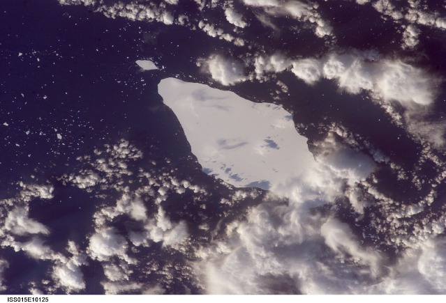
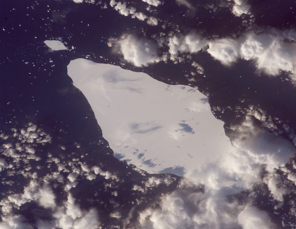
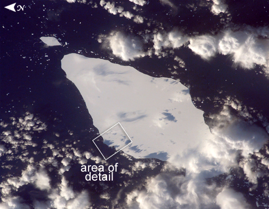
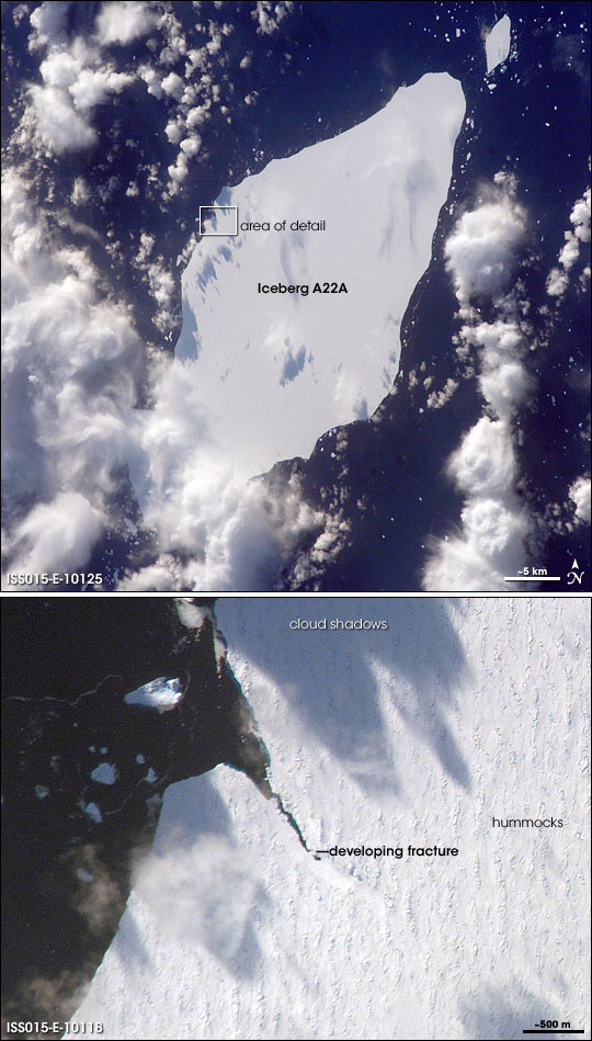
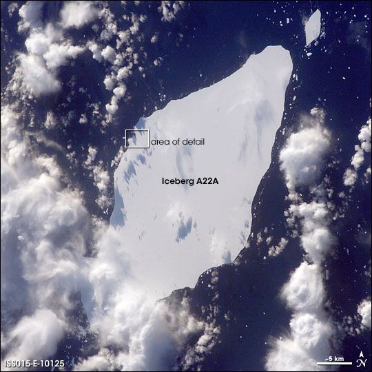
Image Caption: Iceberg A22A, South Atlantic Ocean
This astronaut photograph illustrates the remains of a giant iceberg--designated A22A-- that broke off Antarctica in 2002. The iceberg was photographed on May 30 at a location of 49.9 degrees south latitude, 23.8 degrees west longitude, which is about a third of the distance from South America towards Cape Town, South Africa. A22A is one of the largest icebergs to drift as far north as 50 degrees south latitude, bringing it beneath the daylight path of the International Space Station (ISS). Crew members aboard the ISS were able to locate the ice mass and photograph it, despite the great masses of clouds that often accompany winter storms in the Southern Ocean. The crew's viewing angle was oblique (not looking straight down) from a point to the west of the berg, and the time of day was early afternoon, as shown by the orientation of the cloud shadows. Dimensions of A22A in early June were 49.9 by 23.4 kilometers, giving it an area of 622 square kilometers, or seven times the area of Manhattan Island. The outlined region labeled "Area of Detail" refers to an associated image ISS015-E-10118.
Images of the iceberg are being acquired from the ISS to support a study of massive icebergs--part of NASA International Polar Year activities. The study will increase understanding of the way ice sheets evolve as climate changes. When large masses of ice float into warmer waters north of their usual latitudes, they undergo change at rapidly increased rates. Changes that would take decades to occur in Antarctica can happen in a few years or even months in the warmer conditions at 50 degrees south latitude. The crew of the ISS will continue to collect imagery of the accelerating breakup of iceberg A22A as weather, orbital, and illumination conditions allow.
More information, including Webcams, on the studies conducted on A22 and at other places in the Antarctic can be found at www.thistle.org and the National Snow and Ice Data Center's Icetrek Website (//nsidc.org/icetrek/).
