ISS013-E-81687

| NASA Photo ID | ISS013-E-81687 |
| Focal Length | 28mm |
| Date taken | 2006.09.17 |
| Time taken | 22:52:36 GMT |
Resolutions offered for this image:
1000 x 1511 pixels 540 x 816 pixels 540 x 405 pixels 3032 x 2064 pixels 639 x 435 pixels
1000 x 1511 pixels 540 x 816 pixels 540 x 405 pixels 3032 x 2064 pixels 639 x 435 pixels


Cloud masks available for this image:
Spacecraft nadir point: 31.7° N, 119.4° W
Photo center point: 34.5° N, 118.0° W
Photo center point by machine learning:
Photo center point: 34.5° N, 118.0° W
Photo center point by machine learning:
Nadir to Photo Center: Northeast
Spacecraft Altitude: 186 nautical miles (344km)
Country or Geographic Name: | USA-CALIFORNIA |
Features: | THICK SMOKE, LOS ANGELES |
| Features Found Using Machine Learning: | |
Cloud Cover Percentage: | 10 (1-10)% |
Sun Elevation Angle: | 38° |
Sun Azimuth: | 244° |
Camera: | Kodak DCS760c Electronic Still Camera |
Focal Length: | 28mm |
Camera Tilt: | 45 degrees |
Format: | 3060E: 3060 x 2036 pixel CCD, RGBG array |
Film Exposure: | |
| Additional Information | |
| Width | Height | Annotated | Cropped | Purpose | Links |
|---|---|---|---|---|---|
| 1000 pixels | 1511 pixels | No | Yes | Earth From Space collection | Download Image |
| 540 pixels | 816 pixels | Yes | Yes | Earth From Space collection | Download Image |
| 540 pixels | 405 pixels | Yes | Yes | NASA's Earth Observatory web site | Download Image |
| 3032 pixels | 2064 pixels | No | No | Download Image | |
| 639 pixels | 435 pixels | No | No | Download Image |
Download Packaged File
Download a Google Earth KML for this Image
View photo footprint information
Download a GeoTIFF for this photo
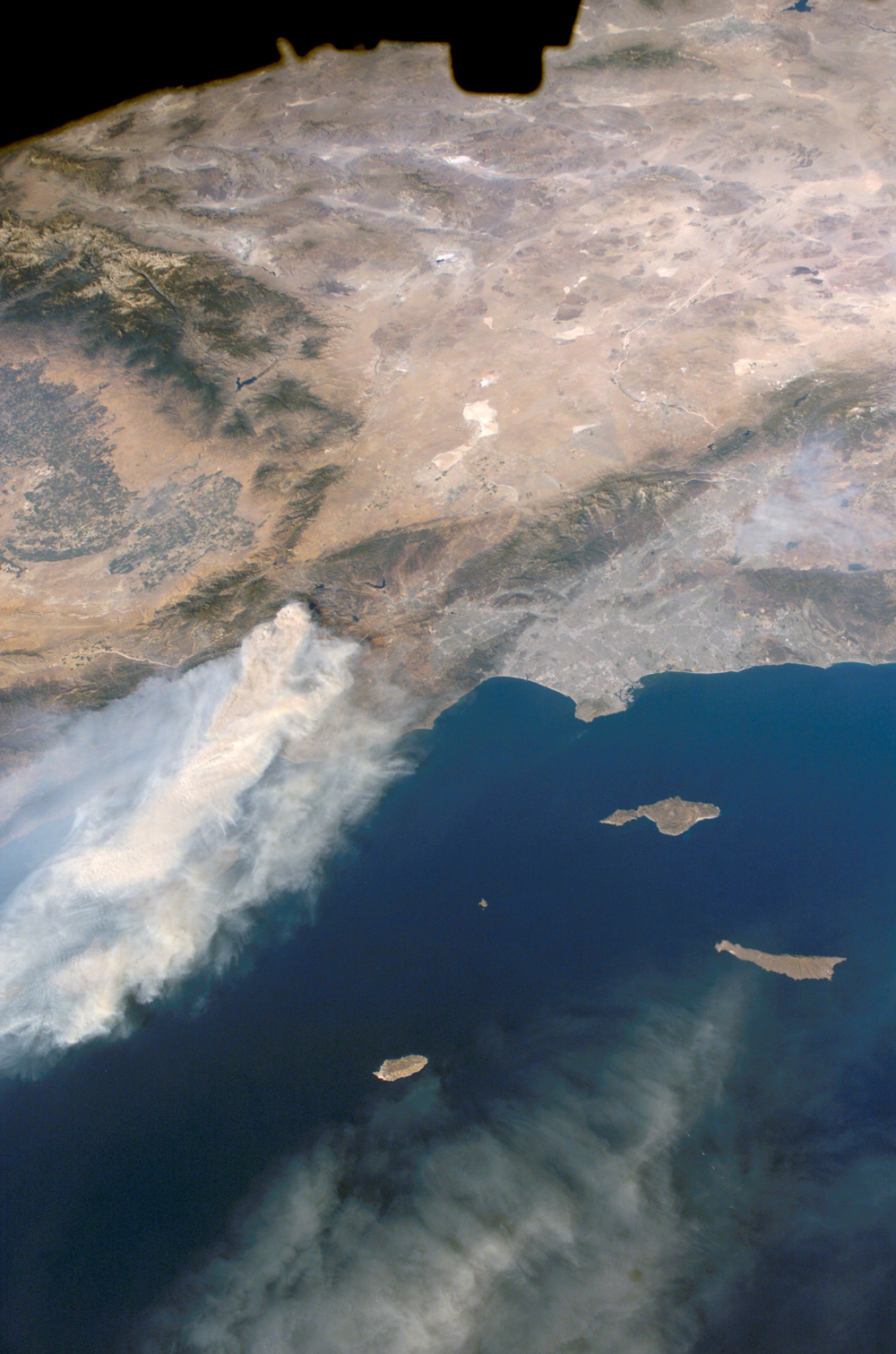
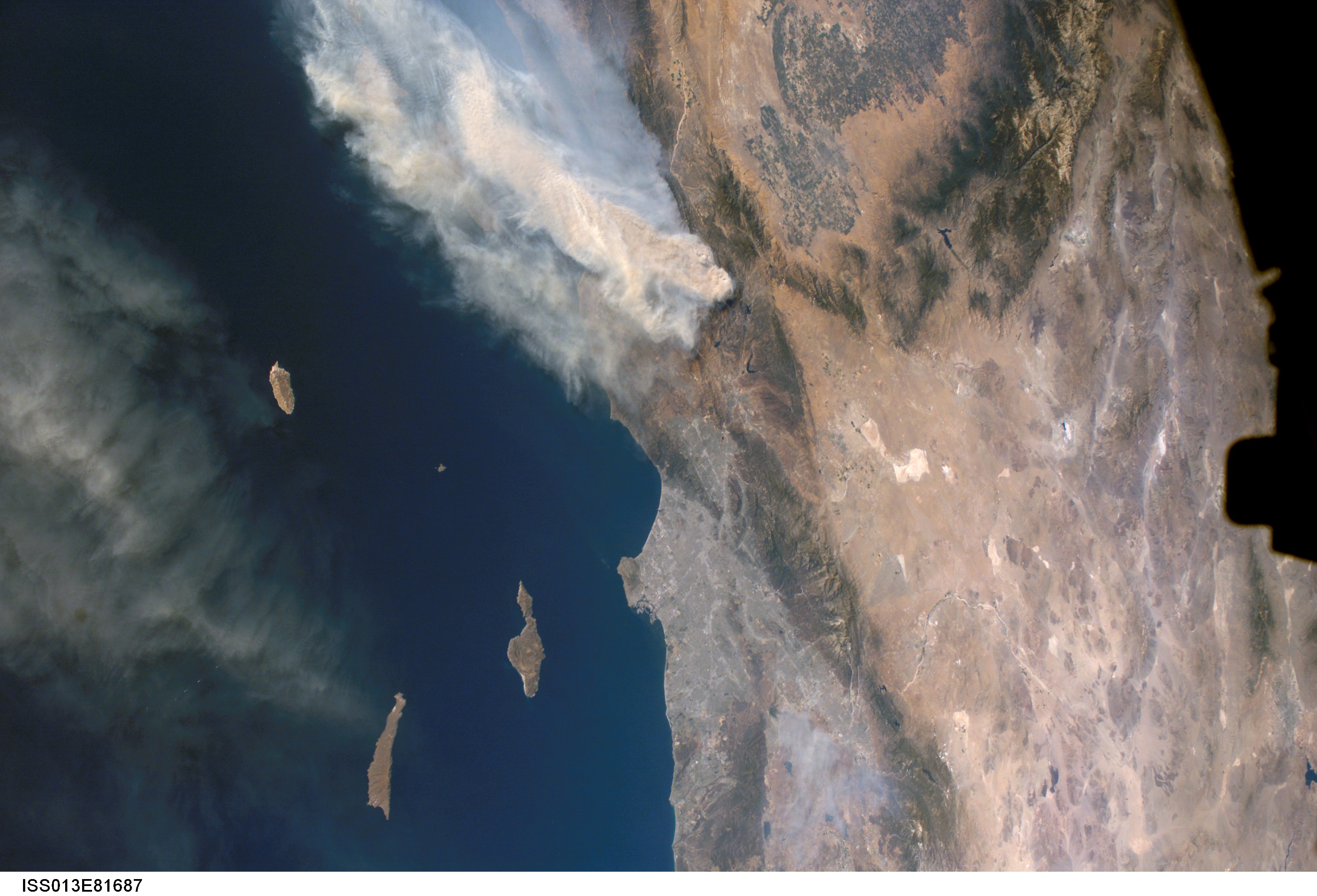
Image Caption: Day Fire, Southern California:
The Day Fire started in Los Padres National Forest north of Los Angeles on September 4, 2006. Easterly winds on September 17 blew the smoke westward, out to sea, and International Space Station astronauts observed this wind shift. In this astronaut photograph, the forested mountains north of Los Angeles appear dark green, and the smoke appears gray. Dense farmland appears at the south end of California's Central Valley.
The extent of the Day Fire smoke plume can be gauged from the gray urban region of greater Los Angeles (image right, center), which stretches along 80 kilometers (50 miles) of coastline. The plume obscures the northern Channel Islands, but the southern Channel Islands are silhouetted against the ocean, in the foreground. In the days before and after this photo was taken, shifting winds moved the smoke in different directions. On September 17, the plume was caught by westerly winds that steered the smoke back towards California--the leading edge of the gray smoke can be seen heading towards San Clemente Island.
