ISS013-E-78506
| NASA Photo ID | ISS013-E-78506 |
| Focal Length | 400mm |
| Date taken | 2006.09.07 |
| Time taken | 08:30:26 GMT |
Resolutions offered for this image:
1000 x 550 pixels 540 x 297 pixels 540 x 334 pixels 3032 x 2064 pixels 639 x 435 pixels
1000 x 550 pixels 540 x 297 pixels 540 x 334 pixels 3032 x 2064 pixels 639 x 435 pixels

Cloud masks available for this image:
Spacecraft nadir point: 51.7° N, 104.3° E
Photo center point: 48.3° N, 96.1° E
Photo center point by machine learning:
Photo center point: 48.3° N, 96.1° E
Photo center point by machine learning:
Nadir to Photo Center: West
Spacecraft Altitude: 184 nautical miles (341km)
Country or Geographic Name: | MONGOLIA |
Features: | HAR LAKE, SPREADING DUNES |
| Features Found Using Machine Learning: | |
Cloud Cover Percentage: | 10 (1-10)% |
Sun Elevation Angle: | 27° |
Sun Azimuth: | 242° |
Camera: | Kodak DCS760c Electronic Still Camera |
Focal Length: | 400mm |
Camera Tilt: | High Oblique |
Format: | 3060E: 3060 x 2036 pixel CCD, RGBG array |
Film Exposure: | |
| Additional Information | |
| Width | Height | Annotated | Cropped | Purpose | Links |
|---|---|---|---|---|---|
| 1000 pixels | 550 pixels | No | Yes | Earth From Space collection | Download Image |
| 540 pixels | 297 pixels | Yes | Yes | Earth From Space collection | Download Image |
| 540 pixels | 334 pixels | Yes | Yes | NASA's Earth Observatory web site | Download Image |
| 3032 pixels | 2064 pixels | No | No | Download Image | |
| 639 pixels | 435 pixels | No | No | Download Image |
Download Packaged File
Download a Google Earth KML for this Image
View photo footprint information
Download a GeoTIFF for this photo
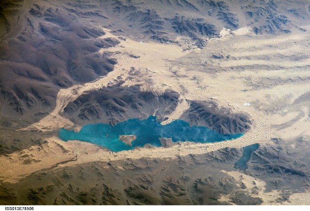
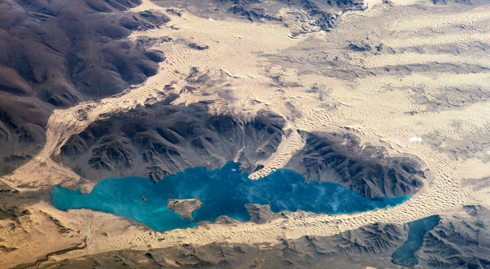
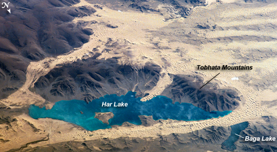
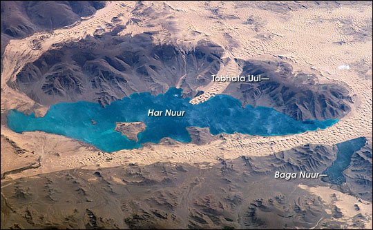
Image Caption: ISS013-E-78506 (7 Sept. 2006) --- Sand dunes near Mongolia's Har Lake are featured in this image photographed by an Expedition 13 crewmember on the International Space Station. Har (or Black) Lake is located in the western part of the country within the Valley of Lakes--part of a system of closed basins that stretches across central Asia. According to scientists, these basins are the remnants of larger paleolakes that had begun to shrink in size by approximately five thousand years ago as regional climate became drier. Today, the Valley of Lakes is an important ecological resource for study of steppe grasslands, and as resting points for large numbers of migratory birds. Portions of the basin are designated as national parks or other protected areas, and Har Lake itself is an ecotourism destination (usually by horseback). This oblique view captures the dynamic nature of the landscape of Har Lake. The lake is encircled by sand dune fields which encroach on the lower slopes of the Tobhata Mountains to the west and south. Gaps in the mountains have been exploited by sand dunes moving eastward (indicating westerly winds) -- the most striking example being a series of dunes entering Har Lake along its southwestern shoreline. Here, the dune forms reflect the channeling of winds through the break in the mountain ridgeline, leading to dune crests oriented transverse to northwesterly winds. Another well-developed line of dunes is visible between Har and Baga Lakes. While these dunes appear to cut across a lake surface, the dunes have in fact moved across a narrow stream channel.
