ISS013-E-26488

| NASA Photo ID | ISS013-E-26488 |
| Focal Length | 800mm |
| Date taken | 2006.05.25 |
| Time taken | 20:47:41 GMT |
1000 x 701 pixels 540 x 379 pixels 540 x 405 pixels 1520 x 1008 pixels 639 x 435 pixels
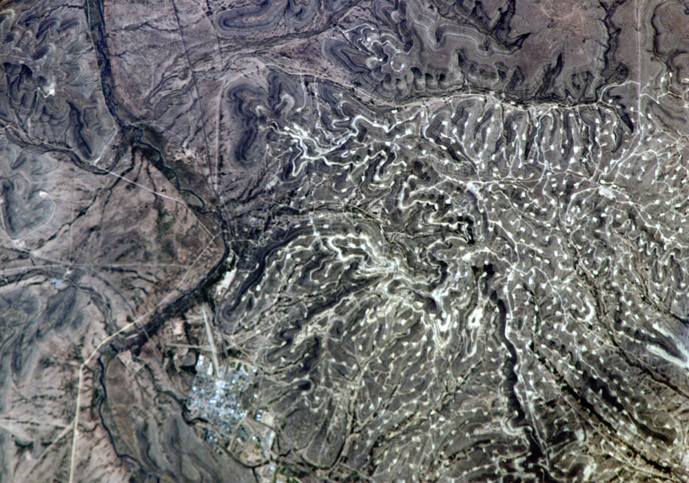
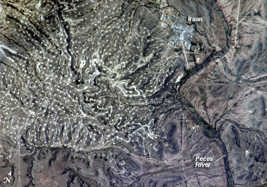
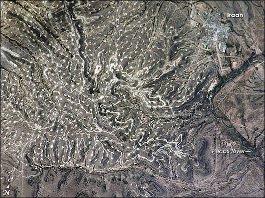
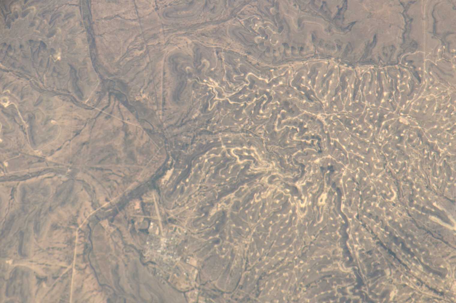
Photo center point: 30.9° N, 101.9° W
Photo center point by machine learning:
Country or Geographic Name: | USA-TEXAS |
Features: | OIL FIELDS, IRAAN, PECOS RIVER |
| Features Found Using Machine Learning: | |
Cloud Cover Percentage: | 10 (1-10)% |
Sun Elevation Angle: | 60° |
Sun Azimuth: | 258° |
Camera: | Kodak DCS760c Electronic Still Camera |
Focal Length: | 800mm |
Camera Tilt: | 12 degrees |
Format: | 3060E: 3060 x 2036 pixel CCD, RGBG array |
Film Exposure: | |
| Additional Information | |
| Width | Height | Annotated | Cropped | Purpose | Links |
|---|---|---|---|---|---|
| 1000 pixels | 701 pixels | No | Yes | Earth From Space collection | Download Image |
| 540 pixels | 379 pixels | Yes | Yes | Earth From Space collection | Download Image |
| 540 pixels | 405 pixels | Yes | Yes | NASA's Earth Observatory web site | Download Image |
| 1520 pixels | 1008 pixels | No | No | Not enhanced | Download Image |
| 639 pixels | 435 pixels | No | No | Download Image |
The Permian Basin of west Texas and southeastern New Mexico is one of the most productive petroleum provinces of North America. The area holds one of the thickest deposits of rock from the Permian Period, which lasted from approximately 290 to 251 million years ago. The Basin is a large depression in the bedrock surface along the southern edge of the North American craton, an ancient core of continental crust. The Basin filled with thick layers of sediment during the Paleozoic Era (about 545 to 251 million years ago) as the region was alternately covered by shallow oceans, or exposed as coastal salt flats. The sediments hardened into primarily organic-rich carbonate and minerals such as common table salt. Later activity in the Earth's crust caused folding of the sedimentary layers, creating ideal conditions for the formation, trapping, and storage of petroleum.
In this astronaut photograph, numerous white well locations and petroleum drilling structures mark the Yates Oil Field in the layered sedimentary rocks of the Permian Basin. The Pecos River bed borders the oil field to the east-northeast. The nearby city of Iraan, Texas, is named for Ira and Ann Yates, the owners of the land where oil was initially discovered in 1926. The city grew in direct proportion to increasing development of the oil field. Today, the town stands out from the underlying sinuous landscape with its sharp angles and straight lines.
The Yates Field started petroleum production in 1926, and by 1995 had produced over 2 billion barrels of oil. While the Yates Field was still actively producing oil and natural gas in 2006, new petroleum discoveries in the area were considered unlikely due to the already-dense well development.
