ISS013-E-18319
| NASA Photo ID | ISS013-E-18319 |
| Focal Length | 800mm |
| Date taken | 2006.05.12 |
| Time taken | 12:48:43 GMT |


Cloud masks available for this image:
Spacecraft nadir point: 48.2° N, 10.5° E
Photo center point: 48.4° N, 11.8° E
Photo center point by machine learning:
Photo center point: 48.4° N, 11.8° E
Photo center point by machine learning:
Nadir to Photo Center: East
Spacecraft Altitude: 184 nautical miles (341km)
Country or Geographic Name: | GERMANY |
Features: | MUNCHEN AIRPORT, AGR., ROADS |
| Features Found Using Machine Learning: | |
Cloud Cover Percentage: | 10 (1-10)% |
Sun Elevation Angle: | 55° |
Sun Azimuth: | 221° |
Camera: | Kodak DCS760c Electronic Still Camera |
Focal Length: | 800mm |
Camera Tilt: | 23 degrees |
Format: | 3060E: 3060 x 2036 pixel CCD, RGBG array |
Film Exposure: | |
| Additional Information | |
| Width | Height | Annotated | Cropped | Purpose | Links |
|---|---|---|---|---|---|
| 540 pixels | 405 pixels | Yes | Yes | Earth From Space collection | Download Image |
| 1520 pixels | 1008 pixels | No | No | Not enhanced | Download Image |
| 639 pixels | 435 pixels | No | No | Download Image |
Download Packaged File
Download a Google Earth KML for this Image
View photo footprint information
Download a GeoTIFF for this photo
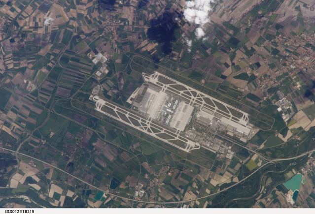
Image Caption: ISS013-E-18319 (12 May 2006) --- Munich International Airport, Germany is featured in this image photographed by an Expedition 13 crewmember on the International Space Station. The Franz Joseph Strauss, or Munich, International Airport served 29 million passengers in 2005, making it the second-busiest airport (behind Frankfurt) in Germany. It is the busiest airport in Germany in terms of domestic passengers, serving over 9 million travelers during 2005. The airport serves the Bayern (Bavaria) region of southeastern Germany, and is a hub for the Lufthansa airline. Like other large international airports around the world, the facility occupies portions of multiple municipalities: Freising, Oberding, Hallbergmoos, and Marzling. The village of Franzheim was demolished, and its 500 residents relocated, during the airport construction. The airport is located 31 kilometers to the northeast of Munich; rather than being an extension of the metropolis, it is surrounded by agricultural fields and small towns. Expansion of the airport occurred in 2003 with the additional of Terminal 2, designed specifically to accommodate the needs of Lufthansa and its partner airlines. This view taken is sufficiently detailed to distinguish individual airplanes on the terminal apron as well as the dark gray-blue rooftop of Terminal 2. The white concrete airport runways are 4 kilometers in length. Surrounding agricultural fields in active use are a variety of shades of green, while the exposed soil of fallow fields are brown to tan.
Munich International Airport, Germany:
The Franz Joseph Strauss, or Munich, International Airport served 29 million passengers in 2005, making it Germany's second-busiest airport, after Frankfurt. The airport serves the Bayern (Bavaria) region of southeastern Germany, and is a hub for the Lufthansa airline. Like other large international airports, the facility occupies portions of multiple municipalities including Freising, Oberding, Hallbergmoos, and Marzling. During the construction of this airport, the village of Franzheim was demolished, and its 500 residents relocated.
The airport lies 31 kilometers to the northeast of Munich. Rather than being an extension of the metropolis, the airport is surrounded by agricultural fields and small towns. The agricultural fields in active use appear in various shades of green, while the exposed soils of fallow fields appear brown to tan. Roadways around the airport appear as thin, intersecting lines. The white concrete airport runways are 4 kilometers in length. At bottom center, the magnified shadows of clouds hang over the scene.
The airport grew in 2003 with the addition of Terminal 2, designed specifically to accommodate the needs of Lufthansa and its partner airlines. This astronaut photograph, taken from the International Space Station, shows enough detail to distinguish individual airplanes on the terminal apron (inset; white rectangle marks location on main image), and the dark gray-blue rooftop of Terminal 2. Astronauts achieve this level of photographic detail--the image resolution approaches 4 meters/pixel--by manually tracking the motion of the ground as the spacecraft orbits the earth at more than 7 kilometers per second. This photo was taken at a relatively slow shutter speed (1/60 second), which equates to more than 100 meters of ground motion. Precise astronaut tracking is required to improve the resolution in detailed images taken with long lenses.
