ISS011-E-12835
| NASA Photo ID | ISS011-E-12835 |
| Focal Length | 28mm |
| Date taken | 2005.09.11 |
| Time taken | 19:31:09 GMT |
Cloud masks available for this image:
Spacecraft nadir point: 31.5° N, 77.5° W
Photo center point: 31.6° N, 75.8° W
Photo center point by machine learning:
Photo center point: 31.6° N, 75.8° W
Photo center point by machine learning:
Nadir to Photo Center: East
Spacecraft Altitude: 187 nautical miles (346km)
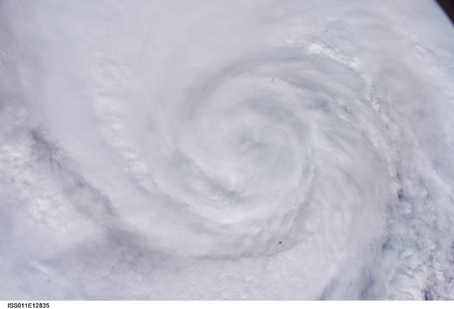
Country or Geographic Name: | ATLANTIC OCEAN |
Features: | HURRICANE OPHELIA, BANDING |
| Features Found Using Machine Learning: | |
Cloud Cover Percentage: | 100 (76-100)% |
Sun Elevation Angle: | 47° |
Sun Azimuth: | 239° |
Camera: | Kodak DCS760c Electronic Still Camera |
Focal Length: | 28mm |
Camera Tilt: | 29 degrees |
Format: | 3060E: 3060 x 2036 pixel CCD, RGBG array |
Film Exposure: | |
| Additional Information | |
| Width | Height | Annotated | Cropped | Purpose | Links |
|---|---|---|---|---|---|
| 3032 pixels | 2008 pixels | No | No | Not enhanced | Download Image |
| 639 pixels | 435 pixels | No | No | Download Image |
Download Packaged File
Download a Google Earth KML for this Image
View photo footprint information
Download a GeoTIFF for this photo
Image Caption: ISS011-E-12835 (11 September 2005, 19:31:09 GMT) --- This image of Hurricane Ophelia was captured by the Expedition 11 crew aboard the International Space Station on the afternoon September 11, 2005.
The hurricane, located at 31.6 degrees north latitude and 75.8 degrees west longitude, was packing winds of 80 miles per hour when the photo was made. (Image credit: NASA)
The hurricane, located at 31.6 degrees north latitude and 75.8 degrees west longitude, was packing winds of 80 miles per hour when the photo was made. (Image credit: NASA)
