ISS011-E-12148
| NASA Photo ID | ISS011-E-12148 |
| Focal Length | 800mm |
| Date taken | 2005.08.26 |
| Time taken | 13:56:38 GMT |
1000 x 713 pixels 540 x 385 pixels 540 x 405 pixels 3032 x 2008 pixels 639 x 435 pixels
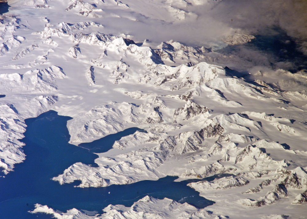
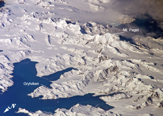
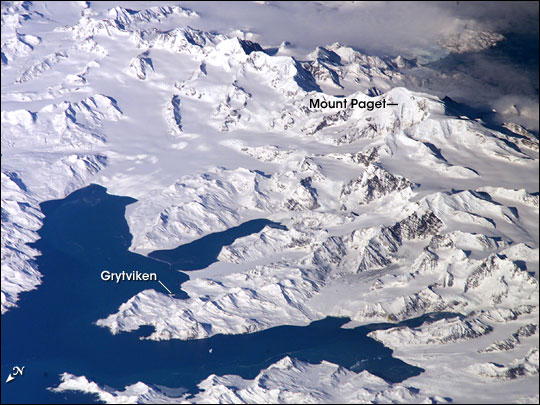
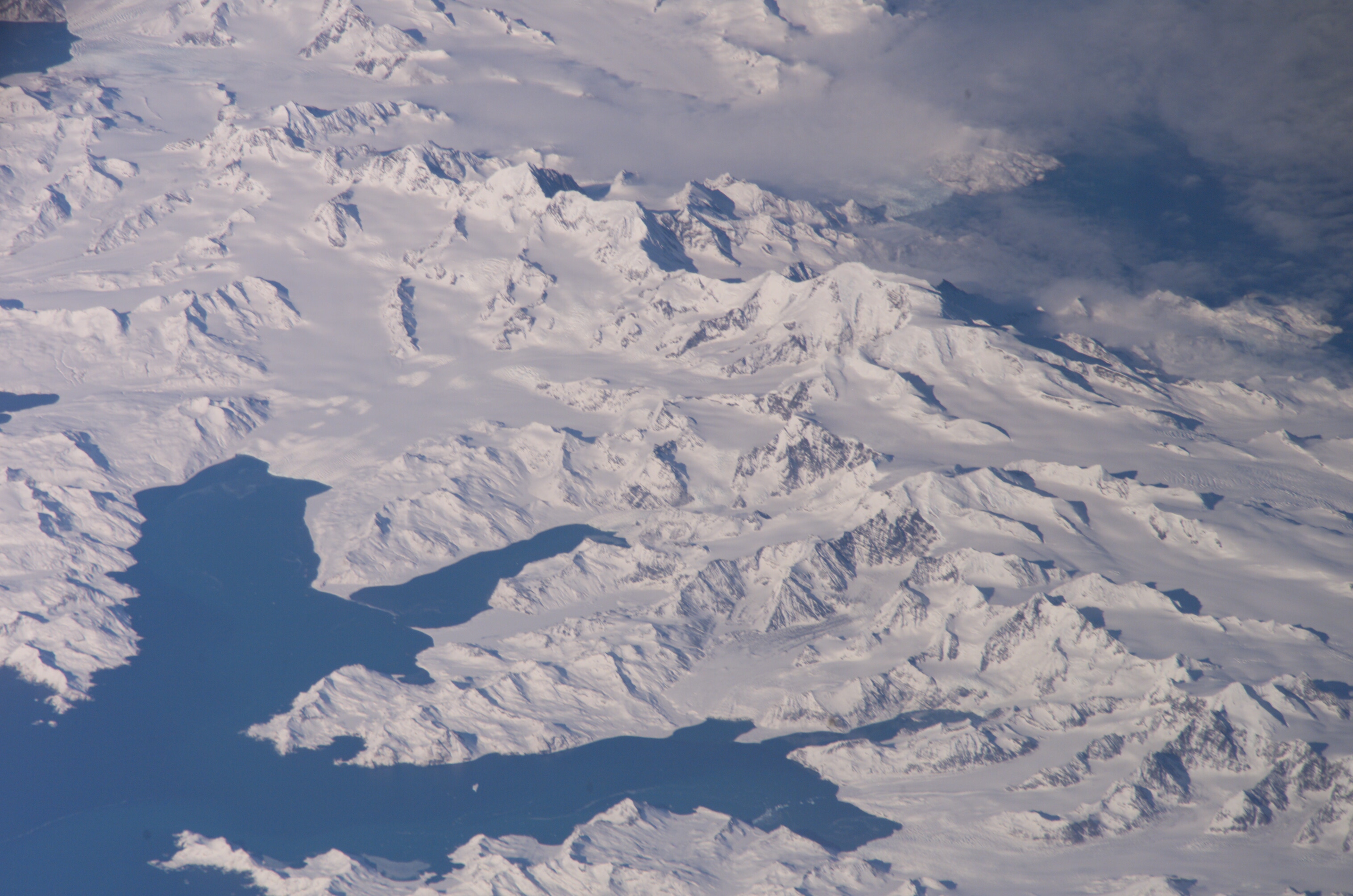
Photo center point: 54.4° S, 36.6° W
Photo center point by machine learning:
Country or Geographic Name: | SOUTH GEORGIA IS. |
Features: | CUMBERLAND B., MTS., GL., SNOW |
| Features Found Using Machine Learning: | |
Cloud Cover Percentage: | 25 (11-25)% |
Sun Elevation Angle: | 31° |
Sun Azimuth: | 15° |
Camera: | Kodak DCS760c Electronic Still Camera |
Focal Length: | 800mm |
Camera Tilt: | High Oblique |
Format: | 3060E: 3060 x 2036 pixel CCD, RGBG array |
Film Exposure: | |
| Additional Information | |
| Width | Height | Annotated | Cropped | Purpose | Links |
|---|---|---|---|---|---|
| 1000 pixels | 713 pixels | No | Yes | Earth From Space collection | Download Image |
| 540 pixels | 385 pixels | Yes | Yes | Earth From Space collection | Download Image |
| 540 pixels | 405 pixels | Yes | Yes | NASA's Earth Observatory web site | Download Image |
| 3032 pixels | 2008 pixels | No | No | Not enhanced | Download Image |
| 639 pixels | 435 pixels | No | No | Download Image |
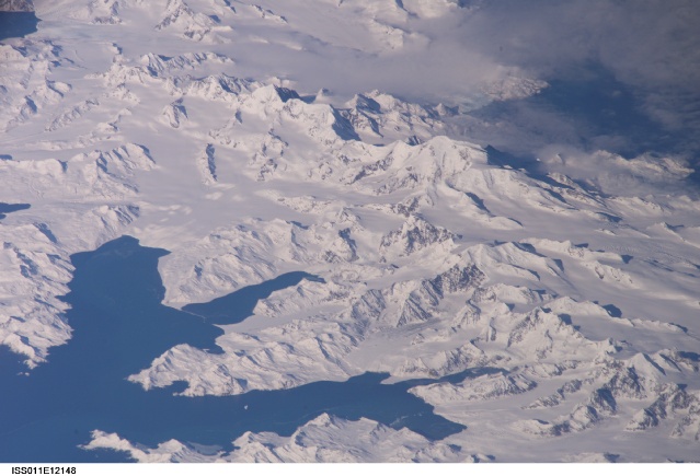
There is no permanent human base on South Georgia Island, a British territory in the South Atlantic Ocean that lies 1,300 kilometers east of the Falkland Islands. Using a long lens (800-millimeter focal length) and an oblique (from the side) view, the crew of the International Space Station captured the rugged and isolated landscape of the northern shore of the island.
South Georgia Island is notable on several fronts. The first recorded explorer to land on the island was Captain James Cook aboard the HMS Resolution in 1775. He mapped part of the coastline, but was discouraged by the thick ice cover, lack of vegetation, and steep mountains. Mt. Paget, the highest peak, rises to 2,934 meters (9,625 feet) above sea level, and the island supports 161 glaciers. Cook named the southernmost point of the island "Cape Disappointment" when he realized he had not reached Antarctica.
The high mountains protect the north and eastern coast of the island from the prevailing gales coming from Antarctica and the west. The steep topography also makes deep bays along the coast, which provide habitat for wildlife and anchorages for whaling ships. The island supports major rookeries of penguins and albatrosses, and large seal populations. This view centers on Mt. Paget and Cumberland Bay. The former whaling station Grytviken is located within the bay. Today, the encampment supports the scientific base for the British Antarctic Survey and Bird Island Research Station.
Early in the 20th century, the island figured prominently in Sir Earnest Shackleton's famous expedition to the Antarctic. When his ship the Endurance became trapped in the Weddell Sea, Shackleton sailed back to the southern coast of South Georgia in 1916, scaled the steep mountain spine of the island, tumbled in to the whaling station Stromness (located just west of this image) and went on to rescue his crew. After Shackleton died several years later, his remains were brought here and buried in Grytviken.
