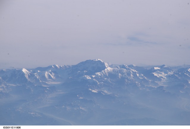
ISS011-E-11806
| NASA Photo ID | ISS011-E-11806 |
| Focal Length | 800mm |
| Date taken | 2005.08.14 |
| Time taken | 15:56:15 GMT |
Cloud masks available for this image:
Spacecraft nadir point: 51.8° N, 147.4° W
Photo center point: 63.1° N, 151.0° W
Photo center point by machine learning:
Photo center point: 63.1° N, 151.0° W
Photo center point by machine learning:
Nadir to Photo Center: North
Spacecraft Altitude: 188 nautical miles (348km)
Country or Geographic Name: | USA-ALASKA |
Features: | MT. MCKINLEY, ALASKA RA., GL. |
| Features Found Using Machine Learning: | |
Cloud Cover Percentage: | 25 (11-25)% |
Sun Elevation Angle: | 11° |
Sun Azimuth: | 81° |
Camera: | Kodak DCS760c Electronic Still Camera |
Focal Length: | 800mm |
Camera Tilt: | High Oblique |
Format: | 3060E: 3060 x 2036 pixel CCD, RGBG array |
Film Exposure: | |
| Additional Information | |
| Width | Height | Annotated | Cropped | Purpose | Links |
|---|---|---|---|---|---|
| 3032 pixels | 2008 pixels | No | No | Not enhanced | Download Image |
| 639 pixels | 435 pixels | No | No | Download Image |
Download Packaged File
Download a Google Earth KML for this Image
View photo footprint information
Download a GeoTIFF for this photo
Image Caption: ISS011-E-11806 (14 August 2005) --- Mount McKinley, Alaska is featured in this image photographed by an Expedition 11 crewmember on the International Space Station. This view - of the highest point in North America (20,230 feet) looks as if it were taken from an aircraft. The Station crewmember took advantage of cloud free skies and the powerful 800 mm lens to photograph this peak, fully 800 miles to the north of the spacecraft, which was located over the Gulf of Alaska. The powerful lenses are difficult to use, requiring motion compensation by the astronaut, so that these kinds of detailed images of horizon detail are seldom taken. The rising sun casts long shadows across the Kahiltna Glacier that angles down from Mt. McKinley (lower left). Other glaciers with moraine lines appear at far left and far right. Despite the blueness inherent in images taken at great distance, this image also shows unusually dense atmospheric haze at lower altitudes: all the valleys in the foreground appear murky due to forest fire smoke.
