ISS011-E-10214
| NASA Photo ID | ISS011-E-10214 |
| Focal Length | 70mm |
| Date taken | 2005.07.07 |
| Time taken | 21:12:01 GMT |

Cloud masks available for this image:
Spacecraft nadir point: 16.0° N, 76.1° W
Photo center point: 19.0° N, 76.6° W
Photo center point by machine learning:
Photo center point: 19.0° N, 76.6° W
Photo center point by machine learning:
Nadir to Photo Center: North
Spacecraft Altitude: 190 nautical miles (352km)
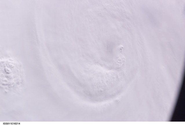
Country or Geographic Name: | CARIBBEAN SEA |
Features: | HURRICANE DENNIS, EYE |
| Features Found Using Machine Learning: | |
Cloud Cover Percentage: | 100 (76-100)% |
Sun Elevation Angle: | 33° |
Sun Azimuth: | 287° |
Camera: | Kodak DCS760c Electronic Still Camera |
Focal Length: | 70mm |
Camera Tilt: | 44 degrees |
Format: | 3060E: 3060 x 2036 pixel CCD, RGBG array |
Film Exposure: | |
| Additional Information | |
| Width | Height | Annotated | Cropped | Purpose | Links |
|---|---|---|---|---|---|
| 3032 pixels | 2008 pixels | No | No | Not enhanced | Download Image |
| 639 pixels | 435 pixels | No | No | Download Image |
Download Packaged File
Download a Google Earth KML for this Image
View photo footprint information
Download a GeoTIFF for this photo
Image Caption: ISS011-E-10214 (7 July 2005) --- At the time of this Expedition 11 digital still camera's image, Hurricane Dennis was churning northwestward through the Caribbean Sea between Jamaica and eastern Cuba packing winds of up to 115 miles per hour. Even though the hurricane had just attained Category 3 intensity, the eye had not yet cleared. This oblique view, captured with a 70mm lens at 21:12:01 gmt, is looking west.
