ISS009-E-9954
| NASA Photo ID | ISS009-E-9954 |
| Focal Length | 180mm |
| Date taken | 2004.06.03 |
| Time taken | 12:21:21 GMT |
Resolutions offered for this image:
396 x 253 pixels 540 x 436 pixels 3032 x 2064 pixels 639 x 435 pixels
396 x 253 pixels 540 x 436 pixels 3032 x 2064 pixels 639 x 435 pixels

Cloud masks available for this image:
Spacecraft nadir point: 37.0° N, 5.8° W
Photo center point: 36.0° N, 5.0° W
Photo center point by machine learning:
Photo center point: 36.0° N, 5.0° W
Photo center point by machine learning:
Nadir to Photo Center: Southeast
Spacecraft Altitude: 195 nautical miles (361km)
Country or Geographic Name: | SPAIN |
Features: | SUNGLINT, WAVES, STRAIT OF GIBRALTAR |
| Features Found Using Machine Learning: | |
Cloud Cover Percentage: | 25 (11-25)% |
Sun Elevation Angle: | 76° |
Sun Azimuth: | 180° |
Camera: | Kodak DCS760c Electronic Still Camera |
Focal Length: | 180mm |
Camera Tilt: | 22 degrees |
Format: | 3060E: 3060 x 2036 pixel CCD, RGBG array |
Film Exposure: | |
| Additional Information | |
| Width | Height | Annotated | Cropped | Purpose | Links |
|---|---|---|---|---|---|
| 396 pixels | 253 pixels | Earth From Space collection | Download Image | ||
| 540 pixels | 436 pixels | Yes | NASA's Earth Observatory web site | Download Image | |
| 3032 pixels | 2064 pixels | No | No | Download Image | |
| 639 pixels | 435 pixels | No | No | Download Image |
Download Packaged File
Download a Google Earth KML for this Image
View photo footprint information
Download a GeoTIFF for this photo
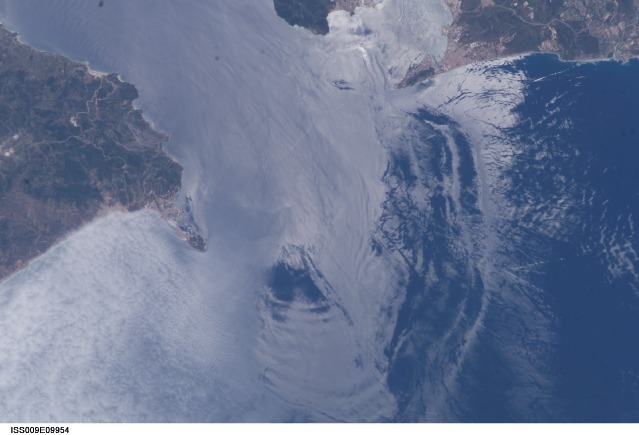
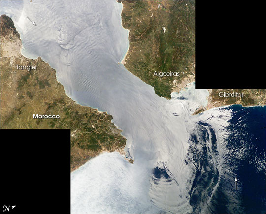
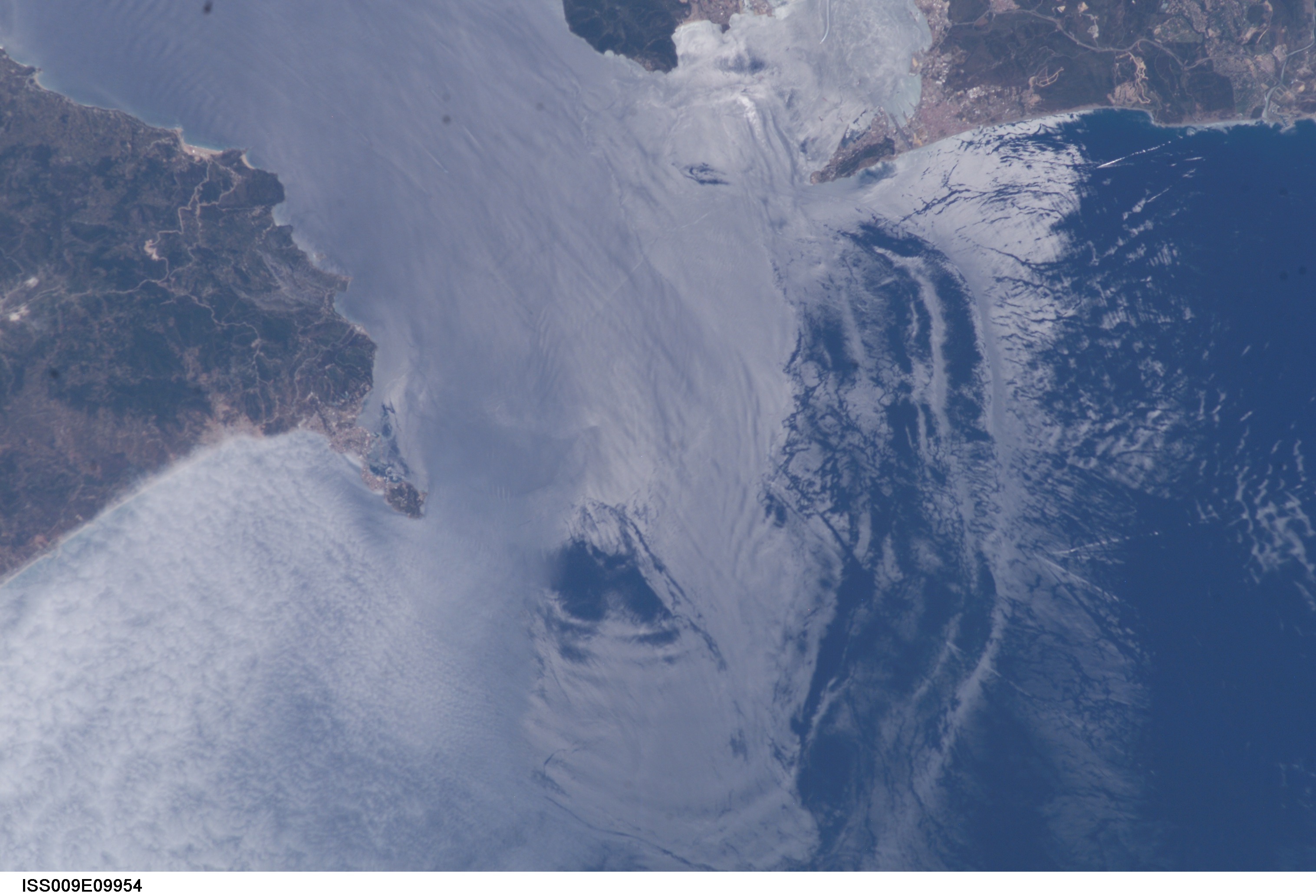
Image Caption: Solitons, Strait of Gibraltar:
Surf's up! This image is part of a mosaic of two photographs (ISS009-E-9952 and ISS009-E-9954) taken by astronauts aboard the International Space Station viewing large internal waves in the Strait of Gibraltar. These subsurface internal waves occur at depths of about 100 m, but appear in the sunglint as giant swells flowing eastward into the Mediterranean Sea.
The narrow Strait of Gibraltar is the gatekeeper for water exchange between the Atlantic Ocean and Mediterranean Sea. A top layer of warm, relatively fresh water from the Atlantic Ocean flows eastward into the Mediterranean Sea. In return, a lower, colder, saltier layer of water flows westward into the North Atlantic ocean. A density boundary separates the layers at about 100 m depth.
Like traffic merging on a highway, the water flow is constricted in both directions because it must pass over a shallow submarine barrier, the Camarinal Sill. When large tidal flows enter the Strait, internal waves (waves at the density boundary layer) are set off at the Camarinal Sill as the high tide relaxes. The waves--sometimes with heights up to 100 m -- travel eastward. Even though the waves occur at great depth and the height of the waves at the surface is almost nothing, they can be traced in the sunglint because they concentrate the biological films on the water surface, creating slight differences in roughness.
In this image, the tidal bore creates internal waves (top arrow) that propagate eastward and expand outward into the Mediterranean in a big arc (near bottom). Other features can be traced in the sun's reflections. Linear and V-shaped patterns (bottom arrow) are wakes of ships, providing evidence for the heavy ship traffic through the narrow waters between Spain and Morocco.
Water features in the sunglint pattern appear to the astronaut to be extremely transient, visible only briefly (a few seconds) as the spacecraft passes rapidly overhead. Photographs from space of the ocean sunglint pattern are a tool for studying physical oceanographic and atmospheric processes and other phenomena that affect surface roughness.
references:
Internal Waves, Strait of Gibraltar
Christopher O. Tiemann, Peter F. Worcester, Bruce D. Cornuelle, Effects of Internal Waves and Bores on Acoustic Transmissions in the Strait of Gibraltar (//www.whoi.edu/science/AOPE/people/tduda/isww/text/index.html), Conference Proceedings from Internal Solitary Wave Workshop, Victoria, B.C., Canada, October 1998. Woods Hole Oceanographic Institution Technical Report WHOI-99-07
Oceanography from the Space Shuttle, Solitons, Gibraltar
