ISS009-E-18123
| NASA Photo ID | ISS009-E-18123 |
| Focal Length | 17mm |
| Date taken | 2004.08.12 |
| Time taken | 21:08:33 GMT |

Cloud masks available for this image:
Spacecraft nadir point: 27.9° N, 87.1° W
Photo center point: 21.0° N, 82.0° W
Photo center point by machine learning:
Photo center point: 21.0° N, 82.0° W
Photo center point by machine learning:
Nadir to Photo Center: Southeast
Spacecraft Altitude: 189 nautical miles (350km)
Country or Geographic Name: | CUBA |
Features: | PAN-HURRICANE CHARLEY |
| Features Found Using Machine Learning: | PAN- |
Cloud Cover Percentage: | 75 (51-75)% |
Sun Elevation Angle: | 43° |
Sun Azimuth: | 264° |
Camera: | Kodak DCS760c Electronic Still Camera |
Focal Length: | 17mm |
Camera Tilt: | High Oblique |
Format: | 3060E: 3060 x 2036 pixel CCD, RGBG array |
Film Exposure: | |
| Additional Information | |
| Width | Height | Annotated | Cropped | Purpose | Links |
|---|---|---|---|---|---|
| 3032 pixels | 2064 pixels | No | No | Download Image | |
| 639 pixels | 435 pixels | No | No | Download Image |
Download Packaged File
Download a Google Earth KML for this Image
View photo footprint information
Download a GeoTIFF for this photo
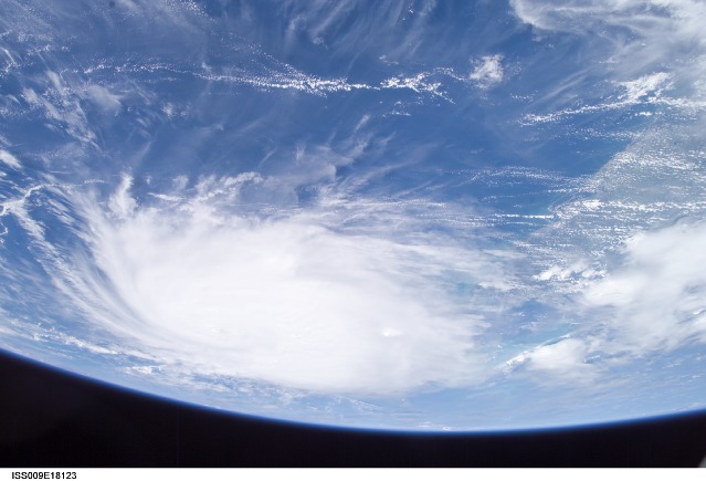
Image Caption: Hurricane Charley:
August 12, 2004 21:08:33 GMT - This panoramic view of Hurricane Charley was taken by the Expedition 9 crew of the International Space Station just after 5PM (EDT), August 12, 2004. The Category Two Hurricane was in the northwest Caribbean Sea, 140 miles south-southeast of Havana, Cuba moving north-northwest at 18mph packing winds of 105mph. In this view looking southeast, the newly formed eye of the storm is just visible and the west coast of Florida from Naples to Tampa Bay may be seen on the right.
August 12, 2004 21:08:33 GMT - This panoramic view of Hurricane Charley was taken by the Expedition 9 crew of the International Space Station just after 5PM (EDT), August 12, 2004. The Category Two Hurricane was in the northwest Caribbean Sea, 140 miles south-southeast of Havana, Cuba moving north-northwest at 18mph packing winds of 105mph. In this view looking southeast, the newly formed eye of the storm is just visible and the west coast of Florida from Naples to Tampa Bay may be seen on the right.
