ISS008-E-9610
| NASA Photo ID | ISS008-E-9610 |
| Focal Length | 800mm |
| Date taken | 2003.12.20 |
| Time taken | 10:36:17 GMT |
Resolutions offered for this image:
540 x 354 pixels 2000 x 1310 pixels 2000 x 1368 pixels 2000 x 1312 pixels 639 x 437 pixels
540 x 354 pixels 2000 x 1310 pixels 2000 x 1368 pixels 2000 x 1312 pixels 639 x 437 pixels


Cloud masks available for this image:
Spacecraft nadir point: 42.7° N, 45.8° E
Photo center point: 43.5° N, 43.5° E
Photo center point by machine learning:
Photo center point: 43.5° N, 43.5° E
Photo center point by machine learning:
Nadir to Photo Center: West
Spacecraft Altitude: 199 nautical miles (369km)
Country or Geographic Name: | RUSSIAN FEDERATION |
Features: | NALCHIK, FOREST, AIRPORT, AGRICULTURE |
| Features Found Using Machine Learning: | |
Cloud Cover Percentage: | 10 (1-10)% |
Sun Elevation Angle: | 20° |
Sun Azimuth: | 205° |
Camera: | Nikon D1 Electronic Still Camera |
Focal Length: | 800mm |
Camera Tilt: | 36 degrees |
Format: | 2000E: 2000 x 1312 pixel CCD, RGBG imager color filter |
Film Exposure: | |
| Additional Information | |
| Width | Height | Annotated | Cropped | Purpose | Links |
|---|---|---|---|---|---|
| 540 pixels | 354 pixels | No | No | Earth From Space collection | Download Image |
| 2000 pixels | 1310 pixels | No | No | Download Image | |
| 2000 pixels | 1368 pixels | No | No | Download Image | |
| 2000 pixels | 1312 pixels | No | No | Original file from camera | Download Image |
| 639 pixels | 437 pixels | No | No | Download Image |
Download Packaged File
Download a Google Earth KML for this Image
View photo footprint information
Download a GeoTIFF for this photo
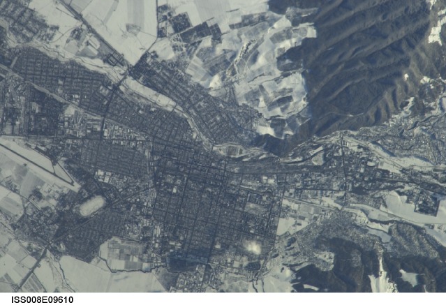
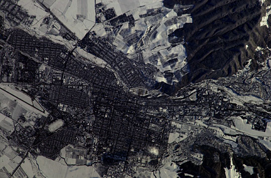
Image Caption: Nalchik, Caucasus Mts., Russian Federation:
This winter-time view of the city of Nalchik on the north slopes of the Greater Caucasus Mountains, was taken with a handheld camera from the International Space Station in early 2004. Rectangles are the city blocks of Nalchik (population ~240,000), a city which lies where the major Terek River exits from the mountains. The river appears as a meandering line crossing the view, slightly diagonally from right to left. Dark forests (top right and lower right) make the mountain sides appear snow free. A dark line, probably a major canal, crosses the view to the lower left corner. Nalchik is a tourist resort and industrial center. It is the major city of the Kabardino-Balkar Republic (population ~ 750,000), one of five small republics on the north slopes of the Caucasus Mountains, 200 km west of Chechnya.
This winter-time view of the city of Nalchik on the north slopes of the Greater Caucasus Mountains, was taken with a handheld camera from the International Space Station in early 2004. Rectangles are the city blocks of Nalchik (population ~240,000), a city which lies where the major Terek River exits from the mountains. The river appears as a meandering line crossing the view, slightly diagonally from right to left. Dark forests (top right and lower right) make the mountain sides appear snow free. A dark line, probably a major canal, crosses the view to the lower left corner. Nalchik is a tourist resort and industrial center. It is the major city of the Kabardino-Balkar Republic (population ~ 750,000), one of five small republics on the north slopes of the Caucasus Mountains, 200 km west of Chechnya.
