ISS008-E-6009
| NASA Photo ID | ISS008-E-6009 |
| Focal Length | 80mm |
| Date taken | 2003.11.14 |
| Time taken | 13:__:__ GMT |
Resolutions offered for this image:
1962 x 3030 pixels 540 x 720 pixels 998 x 1460 pixels 3032 x 2064 pixels 639 x 435 pixels
1962 x 3030 pixels 540 x 720 pixels 998 x 1460 pixels 3032 x 2064 pixels 639 x 435 pixels

Cloud masks available for this image:
Spacecraft nadir point:
Photo center point: 35.5° S, 52.5° W
Photo center point by machine learning:
Photo center point: 35.5° S, 52.5° W
Photo center point by machine learning:
Nadir to Photo Center:
Spacecraft Altitude: nautical miles (0km)
Country or Geographic Name: | ATLANTIC OCEAN |
Features: | PLANKTON BLOOM, POINT DEL ESTE |
| Features Found Using Machine Learning: | |
Cloud Cover Percentage: | 25 (11-25)% |
Sun Elevation Angle: | ° |
Sun Azimuth: | ° |
Camera: | Kodak DCS760c Electronic Still Camera |
Focal Length: | 80mm |
Camera Tilt: | Low Oblique |
Format: | 3060E: 3060 x 2036 pixel CCD, RGBG array |
Film Exposure: | |
| Additional Information | |
| Width | Height | Annotated | Cropped | Purpose | Links |
|---|---|---|---|---|---|
| 1962 pixels | 3030 pixels | No | Yes | Earth From Space collection | Download Image |
| 540 pixels | 720 pixels | Yes | Earth From Space collection | Download Image | |
| 998 pixels | 1460 pixels | Yes | Yes | NASA's Earth Observatory web site | Download Image |
| 3032 pixels | 2064 pixels | No | No | Download Image | |
| 639 pixels | 435 pixels | No | No | Download Image |
Download Packaged File
Download a Google Earth KML for this Image
View photo footprint information
Download a GeoTIFF for this photo
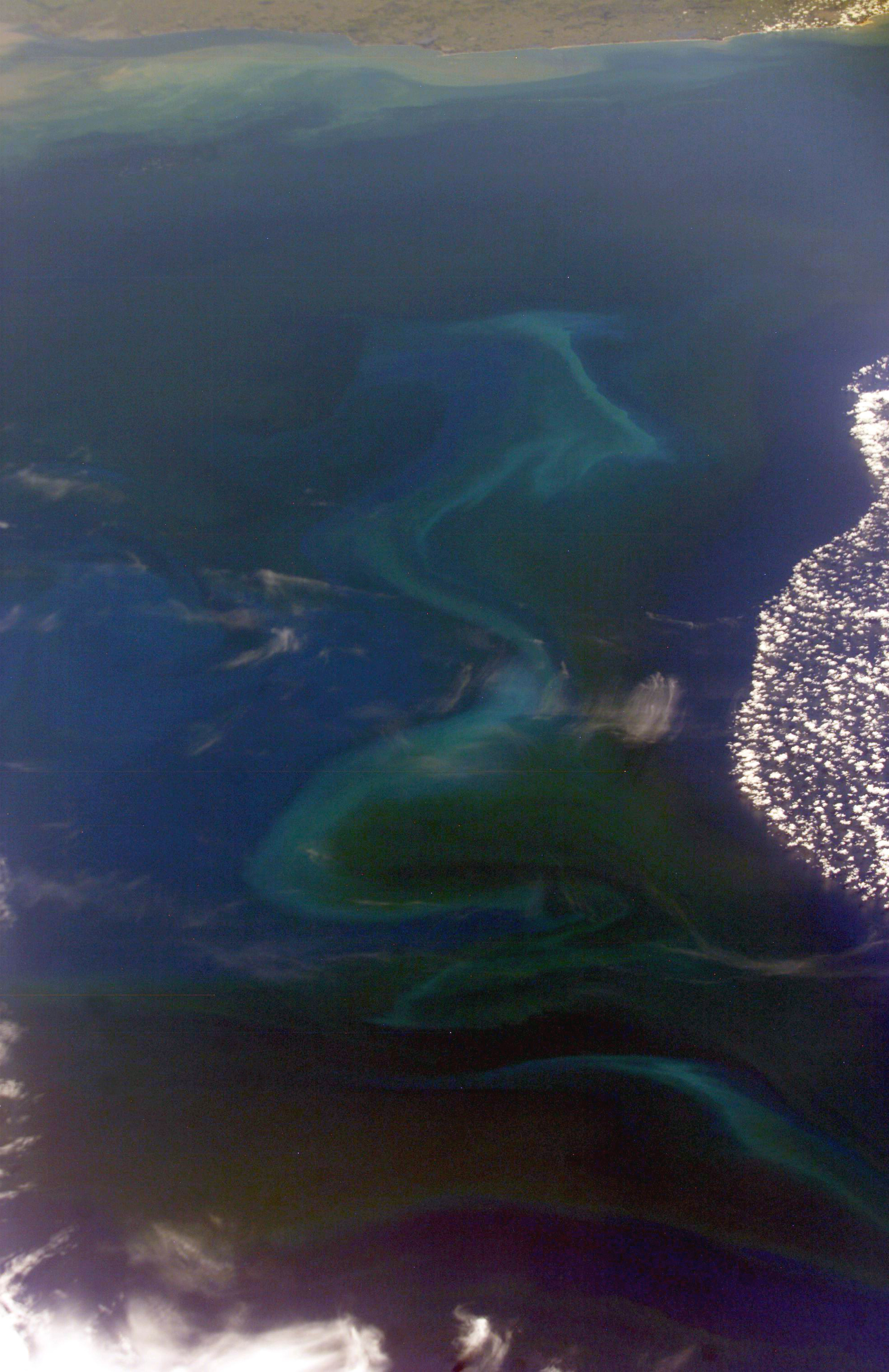
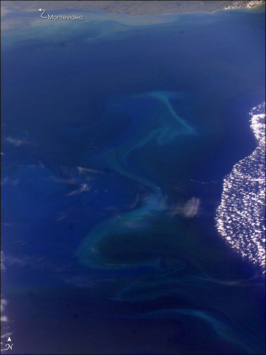
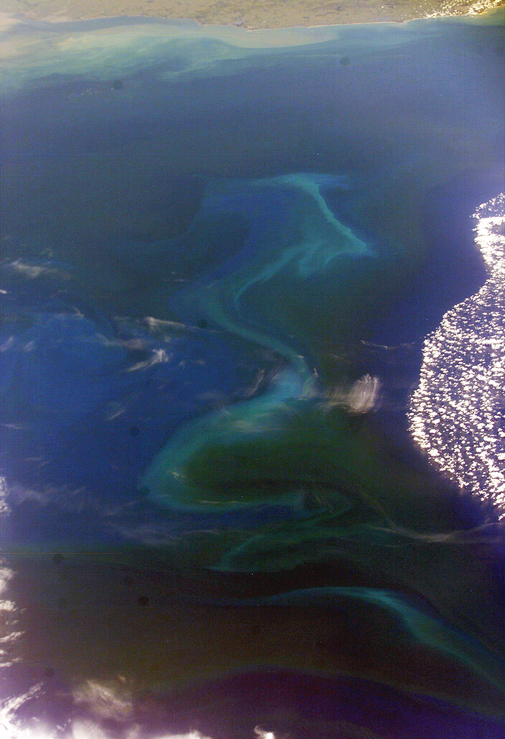
Image Caption: The South Atlantic Ocean off the coast of Argentina and Uruguay is a rich mixing bowl of different water masses. The nutrient-rich waters from the combined Parana and Uruguay Rivers empty into the South Atlantic through the Rio de la Plata. Under the right conditions, especially in spring and early summer, the nutrients fertilize the offshore surface waters allowing for large plankton blooms.
This unique image captures traces of several different water masses just southeast of Montevideo, Uruguay, and the Rio de la Plata. Close to the coast of Uruguay, the muddy fresh water plume snakes along the coast. Farther offshore, broad swirls of light blue-green and darker water mark a bloom of plankton. To the right, deep blue water covered by puffy clouds suggests another, warmer water mass just north of the bloom.
The patterns of the interfaces between these water masses is complicated and dynamic. One of the objectives of International Space Station crew members is to document regions of plankton blooms. These images can be combined with other data sources such as the Sea-viewing Wide Field-of-view Sensor (SeaWiFS) and the Moderate Resolution Imaging Spectroradiometer (MODIS). Space Shuttle and International Space Station photographs frequently supply higher levels of detail than satellite imagery because the astronauts use cameras equipped with long telescopic lenses. In this case, the image is oblique (the spacecraft was approximately 45 degrees south), so exact field-of-view and resolution determinations are difficult. However, we estimate the resolution of the near part of the bloom to be between 50 to 100 meters per pixel. If a station crew can capture blooms on successive days or weeks, scientists may be able to determine something about the finer structure of the interacting water masses, the conditions necessary for blooms, and the evolution of the blooms over time.
