ISS008-E-13240
| NASA Photo ID | ISS008-E-13240 |
| Focal Length | 800mm |
| Date taken | 2004.01.27 |
| Time taken | 10:50:20 GMT |
Resolutions offered for this image:
1024 x 768 pixels 540 x 405 pixels 3032 x 2064 pixels 639 x 435 pixels
1024 x 768 pixels 540 x 405 pixels 3032 x 2064 pixels 639 x 435 pixels


Cloud masks available for this image:
Spacecraft nadir point: 1.9° S, 37.0° E
Photo center point: 3.0° S, 37.5° E
Photo center point by machine learning:
Photo center point: 3.0° S, 37.5° E
Photo center point by machine learning:
Nadir to Photo Center: South
Spacecraft Altitude: 200 nautical miles (370km)
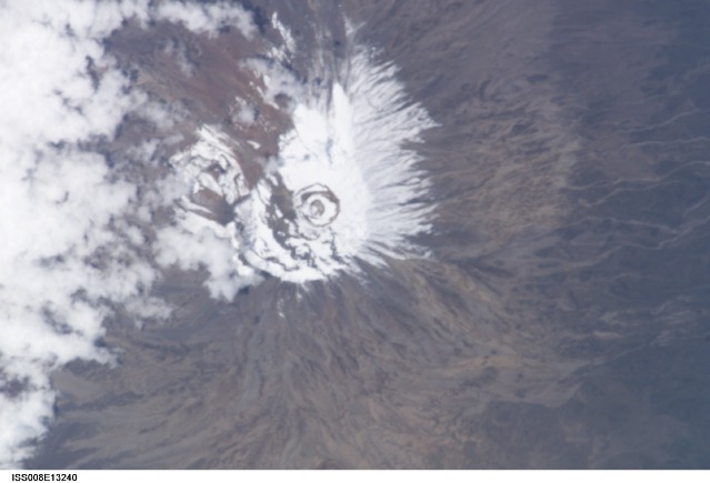
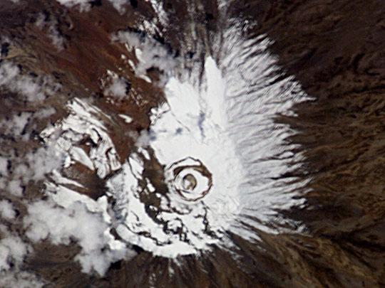
Country or Geographic Name: | TANZANIA |
Features: | MT. KILIMANJARO, SNOW, RAVINES |
| Features Found Using Machine Learning: | |
Cloud Cover Percentage: | 10 (1-10)% |
Sun Elevation Angle: | 67° |
Sun Azimuth: | 223° |
Camera: | Kodak DCS760c Electronic Still Camera |
Focal Length: | 800mm |
Camera Tilt: | 20 degrees |
Format: | 3060E: 3060 x 2036 pixel CCD, RGBG array |
Film Exposure: | |
| Additional Information | |
| Width | Height | Annotated | Cropped | Purpose | Links |
|---|---|---|---|---|---|
| 1024 pixels | 768 pixels | No | Photographic Highlights | Download Image | |
| 540 pixels | 405 pixels | No | Photographic Highlights | Download Image | |
| 3032 pixels | 2064 pixels | No | No | Download Image | |
| 639 pixels | 435 pixels | No | No | Download Image |
Download Packaged File
Download a Google Earth KML for this Image
View photo footprint information
Download a GeoTIFF for this photo
Image Caption: Mt. Kilimanjaro (Tanzania), the highest point in all Africa, is capped by glaciers on its southern and southwestern flanks. An estimated 82 percent of the icecap that crowned the mountain when it was first thoroughly surveyed in 1912 is now gone, and the ice is thinning as well -- by as much as a meter in one area. According to some projections, if recession continues at the present rate, the majority of the glaciers on Kilimanjaro could vanish in the next 15 years. In this image, it is difficult to distinguish the permanent snow cap from a fresh dusting of snow.
