ISS006-E-28546

| NASA Photo ID | ISS006-E-28546 |
| Focal Length | 800mm |
| Date taken | 2003.02.16 |
| Time taken | 15:36:19 GMT |
540 x 357 pixels 1000 x 662 pixels 540 x 334 pixels 3032 x 2064 pixels 639 x 435 pixels
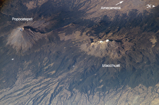
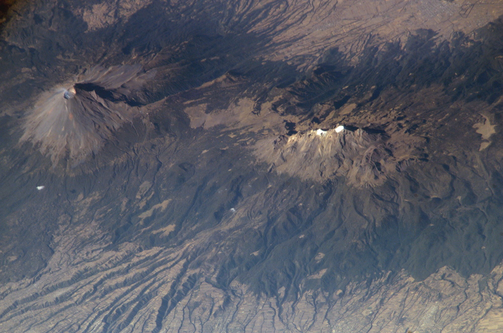
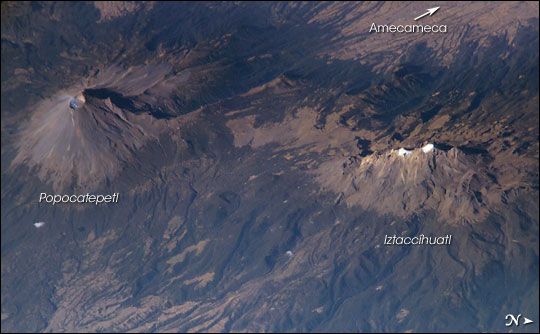

Photo center point: 19.1° N, 98.6° W
Photo center point by machine learning:
Country or Geographic Name: | MEXICO |
Features: | IZTACCIHUATL, POPOCATAPETL |
| Features Found Using Machine Learning: | |
Cloud Cover Percentage: | 10 (1-10)% |
Sun Elevation Angle: | 34° |
Sun Azimuth: | 122° |
Camera: | Kodak DCS760c Electronic Still Camera |
Focal Length: | 800mm |
Camera Tilt: | 38 degrees |
Format: | 3060E: 3060 x 2036 pixel CCD, RGBG array |
Film Exposure: | |
| Additional Information | |
| Width | Height | Annotated | Cropped | Purpose | Links |
|---|---|---|---|---|---|
| 540 pixels | 357 pixels | Yes | Yes | Earth From Space collection | Download Image |
| 1000 pixels | 662 pixels | No | Yes | NASA's Earth Observatory web site | Download Image |
| 540 pixels | 334 pixels | Yes | Yes | NASA's Earth Observatory web site | Download Image |
| 3032 pixels | 2064 pixels | No | No | Download Image | |
| 639 pixels | 435 pixels | No | No | Download Image |
As part of the circum-Pacific "Ring of Fire," Mexico hosts several of the world's most continually active volcanoes, including the massive Popocatepetl (Aztec for "smoking mountain.") This detailed, oblique astronaut photograph also depicts a neighboring volcano, Iztaccihuatl (the "Woman in White.") With North to the right in the scene, the view is a westward-looking perspective.
The faint plume emanating from Popocatepetl's 250- to 450-meter-deep summit crater attests to the significant, ever-present hazard the volcano represents to the 25 million people living in the region, including the nearby city of Amecameca, as well as the metropolitan centers of Mexico City to the northwest and Puebla to the east.
Popocatepetl has produced small, intermittent eruptions since 1994. In addition to the constant danger of eruptions producing ash deposits, pyroclastic flows, and lava (see an earlier astronaut photograph of Popocatepetl erupting), the summit of Popocatepetl also hosts glaciers. These can melt during eruptions to form dangerous mudflows that blanket areas to the south.
In contrast to Popocatepetl's well-defined symmetrical cone, Iztaccihuatl is formed from several overlapping smaller cones that trend north-northwest to south-southeast. Glaciers and year-round snow are also present on Iztaccihuatl (white regions along the peaks). Deep valleys have been eroded into the massive apron of ash and pumice deposits, glacial outwash, and alluvium to the east of the volcano. Despite its close proximity, similar age, and similar geologic character to Popocatepetl, Iztaccihuatl has not erupted in historic times. This has encouraged the establishment of numerous agricultural fields (visible as faint rectilinear patterns in the lower half of the image) on the eastern flank of the mountain.
