ISS005-E-15458
| NASA Photo ID | ISS005-E-15458 |
| Focal Length | 800mm |
| Date taken | 2002.09.25 |
| Time taken | 23:21:07 GMT |
Resolutions offered for this image:
403 x 540 pixels 540 x 724 pixels 540 x 540 pixels 1000 x 1469 pixels 3032 x 2064 pixels 639 x 435 pixels
403 x 540 pixels 540 x 724 pixels 540 x 540 pixels 1000 x 1469 pixels 3032 x 2064 pixels 639 x 435 pixels


Cloud masks available for this image:
Spacecraft nadir point: 23.6° S, 108.0° W
Photo center point: 27.0° S, 109.5° W
Photo center point by machine learning:
Photo center point: 27.0° S, 109.5° W
Photo center point by machine learning:
Nadir to Photo Center: South
Spacecraft Altitude: 205 nautical miles (380km)
Country or Geographic Name: | EASTER ISLAND |
Features: | EASTER ISLAND |
| Features Found Using Machine Learning: | |
Cloud Cover Percentage: | 25 (11-25)% |
Sun Elevation Angle: | 24° |
Sun Azimuth: | 280° |
Camera: | Kodak DCS760c Electronic Still Camera |
Focal Length: | 800mm |
Camera Tilt: | 47 degrees |
Format: | 3060E: 3060 x 2036 pixel CCD, RGBG array |
Film Exposure: | |
| Additional Information | |
| Width | Height | Annotated | Cropped | Purpose | Links |
|---|---|---|---|---|---|
| 403 pixels | 540 pixels | Photographic Highlights | Download Image | ||
| 540 pixels | 724 pixels | Photographic Highlights | Download Image | ||
| 540 pixels | 540 pixels | Yes | Yes | Earth From Space collection | Download Image |
| 1000 pixels | 1469 pixels | No | Yes | NASA's Earth Observatory web site | Download Image |
| 3032 pixels | 2064 pixels | No | No | Download Image | |
| 639 pixels | 435 pixels | No | No | Download Image |
Download Packaged File
Download a Google Earth KML for this Image
View photo footprint information
Download a GeoTIFF for this photo
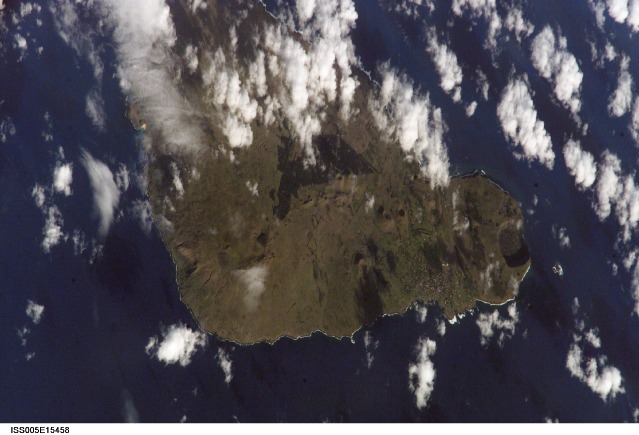
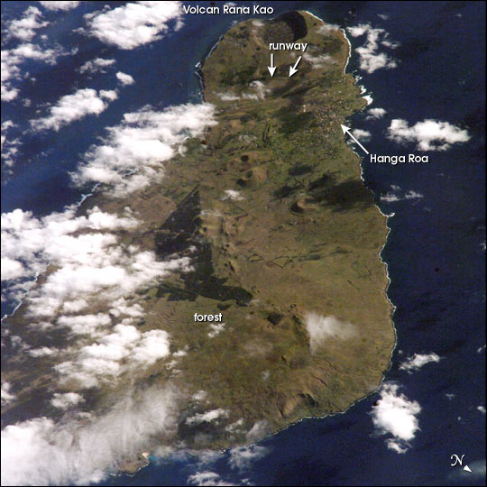
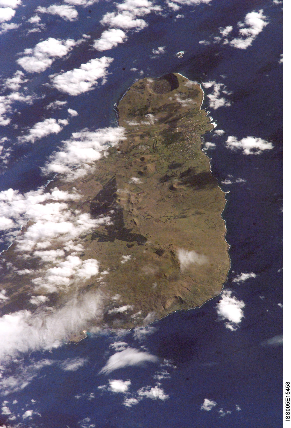
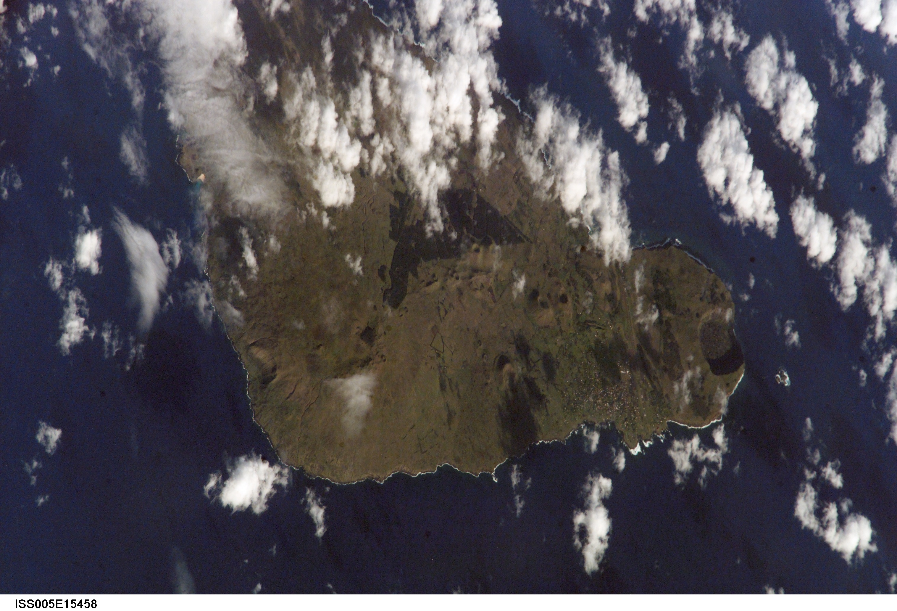
Image Caption: On September 25, 2002, astronauts aboard the International Space Station viewed Easter Island, one of the most remote locations on Earth. Easter Island is more than 2000 miles from the closest populations on Tahiti and Chile--even more remote than astronauts orbiting at 210 n.mi. above the Earth. The island is less than 15 miles long and, until now, has been a photographic challenge for astronauts on space missions.
Although not visible here, Easter Island is perhaps most famous for the giant stone monoliths, known as Moai, that have been placed along the coastline. Archaeologists believe the island was discovered and colonized by Polynesians at about 400 AD. Subsequently, a unique culture developed. The human population grew to levels that could not be sustained by the island. A civil war resulted, and the island's deforestation and ecosystem collapse was nearly complete. Today, a new forest (primarily eucalyptus) has been established in the center of the island (dark green).
The geography of the island is dominated by volcanic landforms, including the large crater Rana Kao at the southwest end of the island and a line of cinder cones that stretch north from the central mountain. A final feature (difficult to see) is the very long runway (Chile's longest) near Rana Kao. The airport serves as an emergency landing site for the Space Shuttle.
