ISS005-E-13461
| NASA Photo ID | ISS005-E-13461 |
| Focal Length | 220mm |
| Date taken | 2002.09.09 |
| Time taken | 17:45:10 GMT |

Cloud masks available for this image:
Spacecraft nadir point: 21.9° S, 67.9° W
Photo center point: 19.0° S, 67.0° W
Photo center point by machine learning:
Photo center point: 19.0° S, 67.0° W
Photo center point by machine learning:
Nadir to Photo Center: North
Spacecraft Altitude: 207 nautical miles (383km)
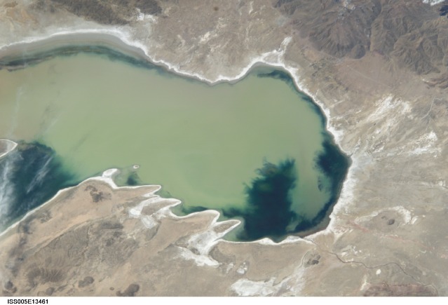
Country or Geographic Name: | BOLIVIA |
Features: | PUBLIC INPUTS (from public image detectives, not NASA): (-19.00,-66.99), SOUTH AMERICA, BOLIVIA, LAGO POOPO, CHALLAPATA, SANTIAGO DE HUARI,BOLIVIA, LAKE POOPO, SANTIAGO DE HUARI,LAGO POOPO, ROUTE 30, ROUTE 603, SANTIAGO DE HUARI, CHALLAPATI, PAMPA AULLAGAS,BOLIVIA, LAGO POOPO,CENTER POINT IS IN LAGO POOPO IN BOLIVIA AND WEST OF SANTIAGO DE HUARI THAT IS INLAND A COUPLE KM FROM THE LAKE'S EAST COAST,LAKE POOPO, PERU,BOLIVIA, POOPO LAKE,BOLIVIA, L. POOPO, PART. FRM., ANTIPLANO MTS.,LAKE, DESERT |
| Features Found Using Machine Learning: | |
Cloud Cover Percentage: | 10 (1-10)% |
Sun Elevation Angle: | 57° |
Sun Azimuth: | 323° |
Camera: | Kodak DCS760c Electronic Still Camera |
Focal Length: | 220mm |
Camera Tilt: | 41 degrees |
Format: | 3060E: 3060 x 2036 pixel CCD, RGBG array |
Film Exposure: | |
| Additional Information | |
| Width | Height | Annotated | Cropped | Purpose | Links |
|---|---|---|---|---|---|
| 3032 pixels | 2064 pixels | No | No | Download Image | |
| 639 pixels | 435 pixels | No | No | Download Image |
Download Packaged File
Download a Google Earth KML for this Image
View photo footprint information
Download a GeoTIFF for this photo
Image Caption: none
