ISS005-E-11189
| NASA Photo ID | ISS005-E-11189 |
| Focal Length | 800mm |
| Date taken | 2002.08.25 |
| Time taken | 06:16:18 GMT |
1000 x 662 pixels 540 x 357 pixels 540 x 334 pixels 3032 x 2064 pixels 639 x 435 pixels
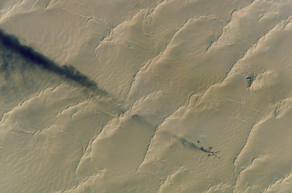
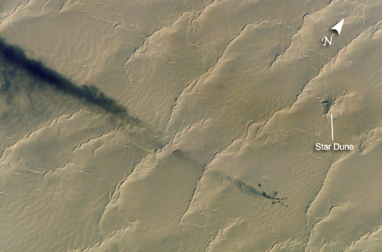
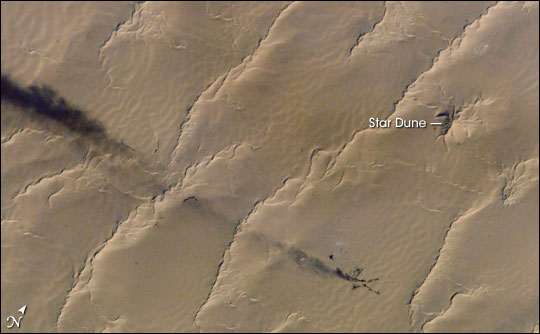
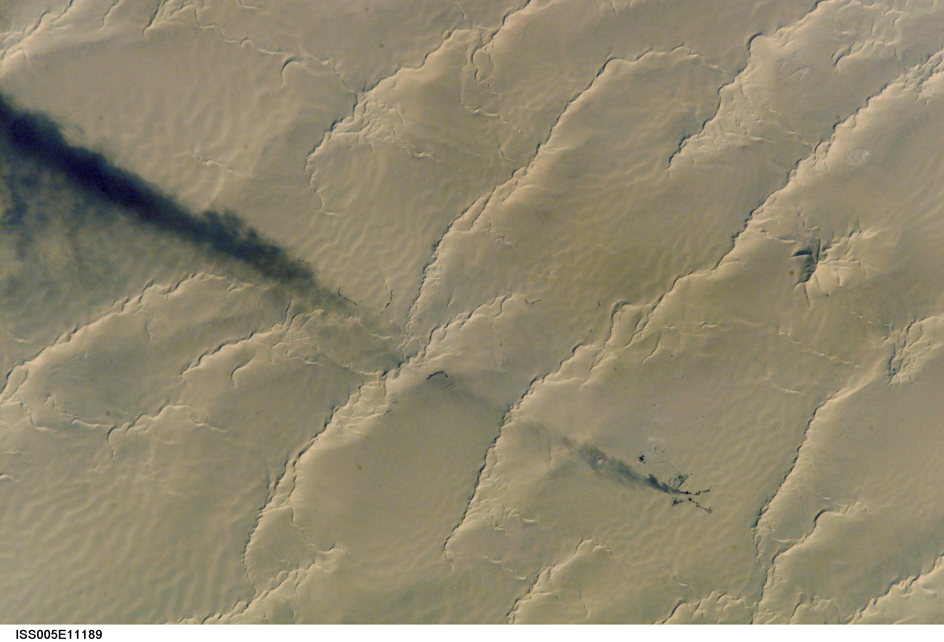
Photo center point: 28.7° N, 22.7° E
Photo center point by machine learning:
Country or Geographic Name: | LIBYA |
Features: | OILWELL, SMOKE, CALANSCIO DUNES |
| Features Found Using Machine Learning: | |
Cloud Cover Percentage: | 10 (1-10)% |
Sun Elevation Angle: | 29° |
Sun Azimuth: | 93° |
Camera: | Kodak DCS760c Electronic Still Camera |
Focal Length: | 800mm |
Camera Tilt: | 23 degrees |
Format: | 3060E: 3060 x 2036 pixel CCD, RGBG array |
Film Exposure: | |
| Additional Information | |
| Width | Height | Annotated | Cropped | Purpose | Links |
|---|---|---|---|---|---|
| 1000 pixels | 662 pixels | No | Yes | Earth From Space collection | Download Image |
| 540 pixels | 357 pixels | Yes | Yes | Earth From Space collection | Download Image |
| 540 pixels | 334 pixels | Yes | Yes | NASA's Earth Observatory web site | Download Image |
| 3032 pixels | 2064 pixels | No | No | Download Image | |
| 639 pixels | 435 pixels | No | No | Download Image |
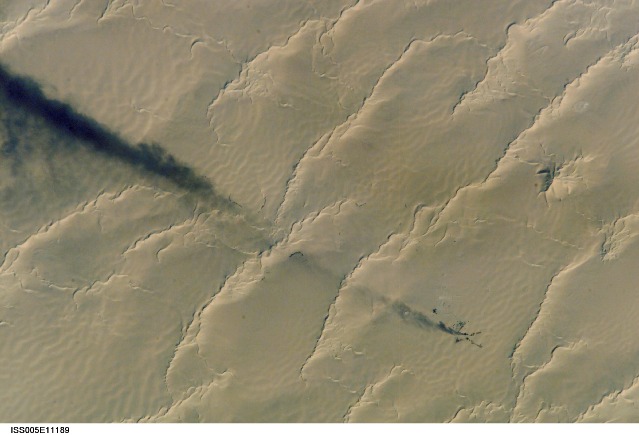
A plume of black smoke blowing westward is silhouetted against linear dunes in the great sand sea of northeast Libya. Smoke from flares at remote well heads is commonly seen by astronauts flying over the Sahara Desert. The plume dispersal pattern visible at the left edge of the image may be due to upper-level winds or gravitational settling of heavier particulates.
The regular pattern of linear dunes is generated by two major winds: the dominant north wind (north is towards the top right) determines the orientation of the sand dunes. Gentler easterly winds, as were blowing when this view was taken, make the dunes asymmetric, with a gentle windward (west) slope and an oversteepened downwind slope. Some oversteepened slopes even cast shadows in the early morning light. One mound of sand (top right), due north of the well head, does not fit the pattern of linear dunes. This type is known as a star dune.
